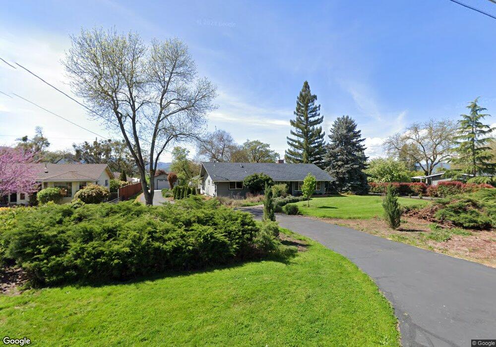
5111 Dobrot Way Central Point, OR 97502
Estimated Value: $413,000 - $528,206
3
Beds
2
Baths
1,627
Sq Ft
$286/Sq Ft
Est. Value
About This Home
This home is located at 5111 Dobrot Way, Central Point, OR 97502 and is currently estimated at $464,802, approximately $285 per square foot. 5111 Dobrot Way is a home located in Jackson County with nearby schools including Jewett Elementary School, Scenic Middle School, and Crater High School.
Ownership History
Date
Name
Owned For
Owner Type
Purchase Details
Closed on
Feb 15, 2017
Sold by
Padovano Stephanie and Ellis Andrea
Bought by
Broomfield Michael
Current Estimated Value
Purchase Details
Closed on
Jan 30, 2017
Sold by
Broomfield Michael
Bought by
Broomfield Michael and Padavano Stephanie
Purchase Details
Closed on
Mar 3, 2005
Sold by
Bruce Norman R and Bruce Bettie M
Bought by
Bruce Norman R and Bruce Bettie M
Create a Home Valuation Report for This Property
The Home Valuation Report is an in-depth analysis detailing your home's value as well as a comparison with similar homes in the area
Home Values in the Area
Average Home Value in this Area
Purchase History
| Date | Buyer | Sale Price | Title Company |
|---|---|---|---|
| Broomfield Michael | $196,666 | First American | |
| Broomfield Michael | -- | None Available | |
| Bruce Norman R | -- | First American Title |
Source: Public Records
Tax History Compared to Growth
Tax History
| Year | Tax Paid | Tax Assessment Tax Assessment Total Assessment is a certain percentage of the fair market value that is determined by local assessors to be the total taxable value of land and additions on the property. | Land | Improvement |
|---|---|---|---|---|
| 2025 | $4,790 | $288,120 | $136,090 | $152,030 |
| 2024 | $4,790 | $279,730 | $132,130 | $147,600 |
| 2023 | $4,636 | $271,590 | $128,290 | $143,300 |
| 2022 | $4,528 | $271,590 | $128,290 | $143,300 |
| 2021 | $4,398 | $263,680 | $124,560 | $139,120 |
| 2020 | $3,785 | $226,910 | $120,940 | $105,970 |
| 2019 | $3,692 | $213,900 | $113,980 | $99,920 |
| 2018 | $3,579 | $207,670 | $110,650 | $97,020 |
| 2017 | $3,489 | $207,670 | $110,650 | $97,020 |
| 2016 | $3,387 | $195,760 | $104,290 | $91,470 |
| 2015 | $2,911 | $195,760 | $104,290 | $91,470 |
| 2014 | $2,837 | $184,530 | $98,310 | $86,220 |
Source: Public Records
Map
Nearby Homes
- 335 Applewood Dr
- 4035 Rock Way
- 356 Marian Ave Unit 40
- 327 Brookhaven Dr
- 4626 N Pacific Hwy
- 413 Sand Pointe Dr
- 426 Bridge Creek Dr
- 422 Castle Rock Dr
- 905 Comet Ave
- 1167 Boulder Ridge St
- 1010 N 3rd St
- 526 Stone Pointe Dr
- 629 Bridge Creek Dr
- 920 N 10th St
- 1317 River Run St
- 1159 Rustler Peak St
- 55 Crater Ln
- 0 Peninger Rd
- 741 Hazel St
- 833 Hazel St
- 5085 Dobrot Way
- 0 Dobrot Way
- 5145 Dobrot Way
- 5075 Dobrot Way
- 5092 Dobrot Way
- 5140 Dobrot Way
- 5175 Dobrot Way
- 5055 Dobrot Way
- 5066 Dobrot Way
- 5168 Dobrot Way
- 5055 Del Mar Dr
- 5065 Del Mar Dr
- 5045 Del Mar Dr
- 5075 Del Mar Dr
- 5035 Del Mar Dr
- 5085 Del Mar Dr
- 5025 Del Mar Dr
- 5205 Dobrot Way
- 5050 Dobrot Way
- 5035 Dobrot Way