Estimated Value: $621,000 - $681,000
4
Beds
3
Baths
2,216
Sq Ft
$295/Sq Ft
Est. Value
About This Home
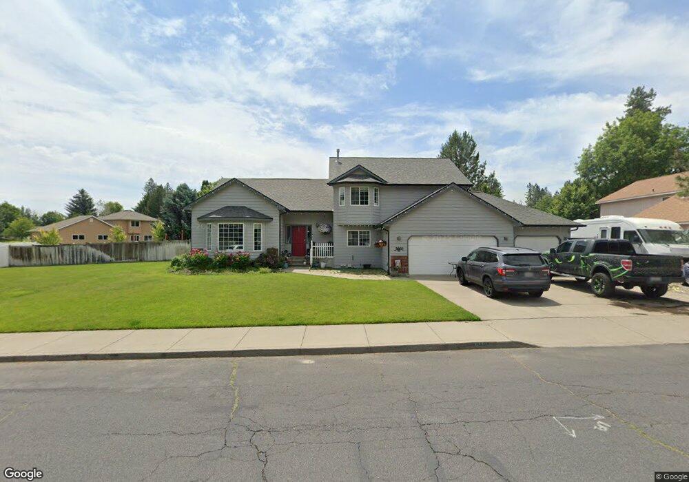
This home is located at 5112 E Lowe Rd, Mead, WA 99021 and is currently estimated at $653,628, approximately $294 per square foot. 5112 E Lowe Rd is a home located in Spokane County with nearby schools including Meadow Ridge Elementary School, Mountainside Middle School, and Mt. Spokane High School.
Ownership History
Date
Name
Owned For
Owner Type
Purchase Details
Closed on
Aug 14, 2012
Sold by
Phillips Adam A
Bought by
Phillips Adam A and Phillips Jenny
Current Estimated Value
Purchase Details
Closed on
May 15, 2012
Sold by
Phillips Jenny A
Bought by
Phillips Adam A
Home Financials for this Owner
Home Financials are based on the most recent Mortgage that was taken out on this home.
Original Mortgage
$242,100
Outstanding Balance
$167,424
Interest Rate
3.86%
Mortgage Type
New Conventional
Estimated Equity
$486,204
Purchase Details
Closed on
Mar 27, 2002
Sold by
Smith Kenneth L and Smith Patricia N
Bought by
Luna Ronald A and Luna Faye M
Home Financials for this Owner
Home Financials are based on the most recent Mortgage that was taken out on this home.
Original Mortgage
$127,608
Interest Rate
6.84%
Create a Home Valuation Report for This Property
The Home Valuation Report is an in-depth analysis detailing your home's value as well as a comparison with similar homes in the area
Home Values in the Area
Average Home Value in this Area
Purchase History
| Date | Buyer | Sale Price | Title Company |
|---|---|---|---|
| Phillips Adam A | -- | None Available | |
| Phillips Adam A | -- | Inland Professional Title Ll | |
| Phillips Adam A | $269,780 | Inland Professional Title Ll | |
| Luna Ronald A | -- | Transnation Title Ins Co |
Source: Public Records
Mortgage History
| Date | Status | Borrower | Loan Amount |
|---|---|---|---|
| Open | Phillips Adam A | $242,100 | |
| Previous Owner | Luna Ronald A | $127,608 |
Source: Public Records
Tax History
| Year | Tax Paid | Tax Assessment Tax Assessment Total Assessment is a certain percentage of the fair market value that is determined by local assessors to be the total taxable value of land and additions on the property. | Land | Improvement |
|---|---|---|---|---|
| 2025 | $6,335 | $615,100 | $125,000 | $490,100 |
| 2024 | $6,335 | $626,800 | $105,000 | $521,800 |
| 2023 | $5,835 | $633,900 | $100,000 | $533,900 |
| 2022 | $5,291 | $643,100 | $97,000 | $546,100 |
| 2021 | $4,423 | $418,600 | $75,000 | $343,600 |
| 2020 | $4,308 | $386,800 | $60,000 | $326,800 |
| 2019 | $3,989 | $361,400 | $50,000 | $311,400 |
| 2018 | $4,196 | $318,900 | $45,000 | $273,900 |
| 2017 | $3,754 | $287,200 | $45,000 | $242,200 |
| 2016 | $3,613 | $270,600 | $45,000 | $225,600 |
| 2015 | $3,349 | $257,600 | $45,000 | $212,600 |
| 2014 | -- | $231,100 | $45,000 | $186,100 |
| 2013 | -- | $0 | $0 | $0 |
Source: Public Records
Map
Nearby Homes
- 14517 N Chronicle St
- 4518 E Lane Park Rd
- 4601 E Pineglen Rd
- 4814 E Peone Pines Dr
- 5711 E Nancy Ln
- 4712 E Winfield Ct
- 4413 E Winfield Rd
- 3928 E Lane Park Rd Unit 30
- 3916 E Tanager Ln
- 3756 E Nyberg Ln Unit Lot 17
- 3912 E Siskin Ln
- 3743 E Nyberg Ln
- 15204 N Chesapeake Rd
- 3103 E Vicksburg Ln
- XX N Deer Ln
- 14826 N Mcclean Ln
- 2908 E Clover Park Ave
- 15317 N Hunters Pointe
- 12504 N Fairview Rd
- 13790 N Bruce Rd
- 5104 E Lowe Rd
- 5103 E Lane Park Ct
- 15025 N Fairview Dr
- 15017 N Fairview Dr
- 5102 E Lane Park Ct
- 5115 E Lowe Rd
- 5109 E Lowe Rd
- 5121 E Lowe Rd
- 15024 N Lowe Rd
- 5103 E Lowe Rd
- 5019 E Lane Park Ct
- 15018 N Fairview Dr
- 5201 E Lowe Rd
- 5110 E Lane Park Ct
- 15026 N Fairview Dr
- 5122 E Lane Park Ct
- 14932 N Fairview Dr
- 15010 N Lowe Rd
- 5022 E Lane Park Ct
- 5112 E Zeus Ct
Your Personal Tour Guide
Ask me questions while you tour the home.