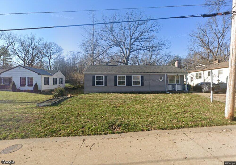
512 Bacon Ave Saint Louis, MO 63119
Estimated Value: $324,000 - $423,000
3
Beds
2
Baths
1,350
Sq Ft
$281/Sq Ft
Est. Value
About This Home
This home is located at 512 Bacon Ave, Saint Louis, MO 63119 and is currently estimated at $380,016, approximately $281 per square foot. 512 Bacon Ave is a home located in St. Louis County with nearby schools including Bristol Elementary School, Hixson Middle School, and Webster Groves High School.
Ownership History
Date
Name
Owned For
Owner Type
Purchase Details
Closed on
Sep 24, 2010
Sold by
Magner Charles R and Magner Susan Mary
Bought by
Magner Charles R and Magner Susan M
Current Estimated Value
Purchase Details
Closed on
Feb 20, 2007
Sold by
Magner Robyn M
Bought by
Magner Charles R and Magner Susan Mary
Purchase Details
Closed on
Jun 17, 1998
Sold by
Marshall Magner John and Marshall Ernestine T
Bought by
John Marshall Magner Trust
Create a Home Valuation Report for This Property
The Home Valuation Report is an in-depth analysis detailing your home's value as well as a comparison with similar homes in the area
Home Values in the Area
Average Home Value in this Area
Purchase History
| Date | Buyer | Sale Price | Title Company |
|---|---|---|---|
| Magner Charles R | -- | None Available | |
| Magner Charles R | -- | None Available | |
| John Marshall Magner Trust | -- | -- | |
| Ernestine T Magner Trust | -- | -- |
Source: Public Records
Tax History Compared to Growth
Tax History
| Year | Tax Paid | Tax Assessment Tax Assessment Total Assessment is a certain percentage of the fair market value that is determined by local assessors to be the total taxable value of land and additions on the property. | Land | Improvement |
|---|---|---|---|---|
| 2025 | $4,497 | $67,050 | $60,670 | $6,380 |
| 2024 | $4,497 | $64,510 | $50,540 | $13,970 |
| 2023 | $4,475 | $64,510 | $50,540 | $13,970 |
| 2022 | $3,573 | $47,710 | $36,400 | $11,310 |
| 2021 | $3,561 | $47,710 | $36,400 | $11,310 |
| 2020 | $3,461 | $43,180 | $34,900 | $8,280 |
| 2019 | $3,436 | $43,180 | $34,900 | $8,280 |
| 2018 | $3,426 | $38,240 | $27,300 | $10,940 |
| 2017 | $3,404 | $38,240 | $27,300 | $10,940 |
| 2016 | $3,343 | $35,970 | $19,630 | $16,340 |
| 2015 | $3,353 | $35,970 | $19,630 | $16,340 |
| 2014 | $3,532 | $36,880 | $16,130 | $20,750 |
Source: Public Records
Map
Nearby Homes
- 529 Cyril Dr
- 28 Berry Road Park
- 336 Madison Ave
- 426 W Kirkham Ave
- 404 W Kirkham Ave
- 827 Yosemite Dr
- 312 Madison Ave
- 218 Euclid Ave
- 330 Lithia Ave
- 9721 Greenwood Terrace
- 2918 Wingate Ct
- 1048 Martha Ln
- 617 N Elm Ave
- 1146 Kortwright Ave
- 144 S Rock Hill Rd
- 9714 Whitestone Terrace
- 1025 Glenmoor Ln
- 200 Blackmer Place
- 1120 Gilbert Ave
- 546 Holland Ave