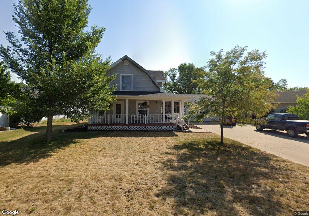
512 Front St Fairfax, IA 52228
Estimated Value: $305,000 - $322,000
4
Beds
3
Baths
2,706
Sq Ft
$116/Sq Ft
Est. Value
About This Home
This home is located at 512 Front St, Fairfax, IA 52228 and is currently estimated at $315,101, approximately $116 per square foot. 512 Front St is a home located in Linn County with nearby schools including Prairie Crest Elementary School, Prairie View Elementary School, and Prairie Ridge Elementary School.
Ownership History
Date
Name
Owned For
Owner Type
Purchase Details
Closed on
Aug 18, 2011
Sold by
Kolosik Shawn Lynn and Kolosik Dawn Marie
Bought by
Daly Michael A
Current Estimated Value
Home Financials for this Owner
Home Financials are based on the most recent Mortgage that was taken out on this home.
Original Mortgage
$162,000
Outstanding Balance
$13,446
Interest Rate
4.64%
Mortgage Type
VA
Estimated Equity
$301,655
Purchase Details
Closed on
Apr 15, 2005
Sold by
Hutchcroft Thomas M and Hutchcroft Karen L
Bought by
Kolosik Shawn Lynn and Kolosik Dawn Marie
Home Financials for this Owner
Home Financials are based on the most recent Mortgage that was taken out on this home.
Original Mortgage
$118,000
Interest Rate
5.88%
Mortgage Type
Fannie Mae Freddie Mac
Create a Home Valuation Report for This Property
The Home Valuation Report is an in-depth analysis detailing your home's value as well as a comparison with similar homes in the area
Home Values in the Area
Average Home Value in this Area
Purchase History
| Date | Buyer | Sale Price | Title Company |
|---|---|---|---|
| Daly Michael A | $179,500 | None Available | |
| Kolosik Shawn Lynn | $159,500 | -- |
Source: Public Records
Mortgage History
| Date | Status | Borrower | Loan Amount |
|---|---|---|---|
| Open | Daly Michael A | $162,000 | |
| Previous Owner | Kolosik Shawn Lynn | $118,000 |
Source: Public Records
Tax History Compared to Growth
Tax History
| Year | Tax Paid | Tax Assessment Tax Assessment Total Assessment is a certain percentage of the fair market value that is determined by local assessors to be the total taxable value of land and additions on the property. | Land | Improvement |
|---|---|---|---|---|
| 2025 | $3,650 | $297,300 | $25,200 | $272,100 |
| 2024 | $3,624 | $261,600 | $25,200 | $236,400 |
| 2023 | $3,624 | $261,600 | $25,200 | $236,400 |
| 2022 | $3,570 | $217,000 | $25,200 | $191,800 |
| 2021 | $3,552 | $217,000 | $25,200 | $191,800 |
| 2020 | $3,552 | $205,100 | $25,200 | $179,900 |
| 2019 | $3,160 | $184,700 | $25,200 | $159,500 |
| 2018 | $3,082 | $184,700 | $25,200 | $159,500 |
| 2017 | $3,276 | $185,400 | $25,200 | $160,200 |
| 2016 | $3,276 | $185,400 | $25,200 | $160,200 |
| 2015 | $3,106 | $177,800 | $25,200 | $152,600 |
| 2014 | $3,106 | $177,800 | $25,200 | $152,600 |
| 2013 | $2,952 | $177,800 | $25,200 | $152,600 |
Source: Public Records
Map
Nearby Homes
- 117 Prairie Ave
- 61 E Cemetery Rd
- 551 Vanderbilt St
- 408 Driftwood Ln
- 110 Skyview Ave
- 315 Highland Ct
- 247 Whirlaway Ln
- 341 Highland Ct
- 603 Heartland St
- 247 Kelso Ln Unit 247
- 1433 Deerfield Dr
- 1416 Applewood Dr
- 1382 Foxtail Dr
- 1385 Heartland St
- 1442 Cardinal Dr
- 1510 Cardinal Dr
- 1518 Cardinal Dr
- 1519 Cardinal Dr
- 1523 Eagleview Dr
- 1537 Deerfield Dr