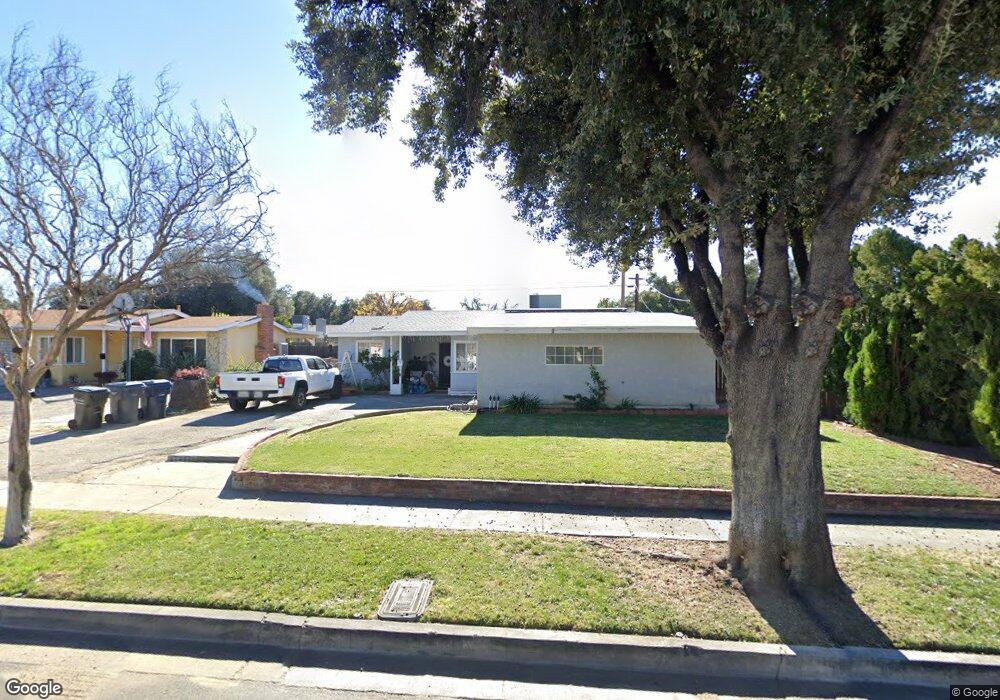
512 Mulvihill Ave Redlands, CA 92374
North Redlands NeighborhoodEstimated Value: $437,443 - $601,000
3
Beds
1
Bath
960
Sq Ft
$514/Sq Ft
Est. Value
About This Home
This home is located at 512 Mulvihill Ave, Redlands, CA 92374 and is currently estimated at $493,361, approximately $513 per square foot. 512 Mulvihill Ave is a home located in San Bernardino County with nearby schools including Lugonia Elementary School, Clement Middle School, and Citrus Valley High School.
Ownership History
Date
Name
Owned For
Owner Type
Purchase Details
Closed on
Dec 11, 2008
Sold by
Posadas Aurelio and Posadas Donna J
Bought by
Posadas Aurelio
Current Estimated Value
Home Financials for this Owner
Home Financials are based on the most recent Mortgage that was taken out on this home.
Original Mortgage
$123,900
Interest Rate
6.16%
Mortgage Type
New Conventional
Create a Home Valuation Report for This Property
The Home Valuation Report is an in-depth analysis detailing your home's value as well as a comparison with similar homes in the area
Home Values in the Area
Average Home Value in this Area
Purchase History
| Date | Buyer | Sale Price | Title Company |
|---|---|---|---|
| Posadas Aurelio | -- | Chicago Title |
Source: Public Records
Mortgage History
| Date | Status | Borrower | Loan Amount |
|---|---|---|---|
| Closed | Posadas Aurelio | $123,900 |
Source: Public Records
Tax History Compared to Growth
Tax History
| Year | Tax Paid | Tax Assessment Tax Assessment Total Assessment is a certain percentage of the fair market value that is determined by local assessors to be the total taxable value of land and additions on the property. | Land | Improvement |
|---|---|---|---|---|
| 2025 | $540 | $42,886 | $11,365 | $31,521 |
| 2024 | $540 | $42,045 | $11,142 | $30,903 |
| 2023 | $539 | $41,221 | $10,924 | $30,297 |
| 2022 | $532 | $40,413 | $10,710 | $29,703 |
| 2021 | $541 | $39,621 | $10,500 | $29,121 |
| 2020 | $533 | $39,214 | $10,392 | $28,822 |
| 2019 | $519 | $38,445 | $10,188 | $28,257 |
| 2018 | $508 | $37,691 | $9,988 | $27,703 |
| 2017 | $504 | $36,952 | $9,792 | $27,160 |
| 2016 | $498 | $36,227 | $9,600 | $26,627 |
| 2015 | $495 | $35,683 | $9,456 | $26,227 |
| 2014 | $487 | $34,984 | $9,271 | $25,713 |
Source: Public Records
Map
Nearby Homes
- 638 E Pioneer Ave
- 806 Anderson Ct
- 1602 Heron Ct
- 1808 Cave St
- 1602 Glover St
- 102 E Pioneer Ave
- 1734 Orange St
- 914 Gail Ave
- 1837 River Bend Dr
- 1107 Alexis Ln
- 920 E Pennsylvania Ave
- 325 Deodar St
- 2046 Meyer Ln
- 2051 Meyer Ln
- 2070 Meyer Ln
- 2069 Meyer Ln
- 1636 Webster St
- 402 Baldwin Ave
- 401 W Pioneer Ave
- 420 Deodar St
- 516 Mulvihill Ave
- 508 Mulvihill Ave
- 513 Hartzell Ave
- 509 Hartzell Ave
- 517 Hartzell Ave
- 520 Mulvihill Ave
- 504 Mulvihill Ave
- 513 Mulvihill Ave
- 521 Hartzell Ave
- 505 Hartzell Ave
- 517 Mulvihill Ave
- 509 Mulvihill Ave
- 624 Mulvihill Ave
- 432 Mulvihill Ave
- 521 Mulvihill Ave
- 505 Mulvihill Ave
- 625 Hartzell Ave
- 413 Hartzell Ave
- 525 Mulvihill Ave
- 431 Mulvihill Ave