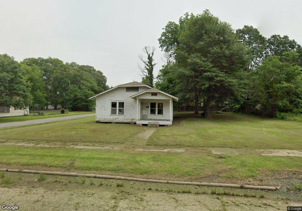
512 N 4th St Mc Gehee, AR 71654
Estimated Value: $19,957 - $43,000
--
Bed
1
Bath
1,516
Sq Ft
$21/Sq Ft
Est. Value
About This Home
This home is located at 512 N 4th St, Mc Gehee, AR 71654 and is currently estimated at $31,479, approximately $20 per square foot. 512 N 4th St is a home located in Desha County with nearby schools including McGehee Elementary School, Conner Middle School, and McGehee High School.
Ownership History
Date
Name
Owned For
Owner Type
Purchase Details
Closed on
Dec 28, 2022
Sold by
Desha County
Bought by
Croff Jacqueline
Current Estimated Value
Purchase Details
Closed on
Dec 29, 2010
Sold by
Anglin Robin R
Bought by
Terry Joe
Purchase Details
Closed on
Jan 9, 2009
Sold by
Anglin Jack
Bought by
Anglin Robin R
Purchase Details
Closed on
Oct 19, 2006
Sold by
Vincent Robert E and Vincent June D
Bought by
Anglin Jack and Anglin Robin R
Purchase Details
Closed on
Apr 4, 2002
Bought by
Jack and Robin Anglin
Purchase Details
Closed on
Feb 6, 1974
Bought by
June Vincent
Create a Home Valuation Report for This Property
The Home Valuation Report is an in-depth analysis detailing your home's value as well as a comparison with similar homes in the area
Home Values in the Area
Average Home Value in this Area
Purchase History
| Date | Buyer | Sale Price | Title Company |
|---|---|---|---|
| Croff Jacqueline | $988 | -- | |
| Terry Joe | $8,500 | None Available | |
| Anglin Robin R | -- | None Available | |
| Anglin Jack | $12,000 | None Available | |
| Jack | $12,000 | -- | |
| June Vincent | -- | -- |
Source: Public Records
Tax History Compared to Growth
Tax History
| Year | Tax Paid | Tax Assessment Tax Assessment Total Assessment is a certain percentage of the fair market value that is determined by local assessors to be the total taxable value of land and additions on the property. | Land | Improvement |
|---|---|---|---|---|
| 2025 | $58 | $1,100 | $600 | $500 |
| 2024 | $58 | $1,100 | $600 | $500 |
| 2023 | $58 | $1,100 | $600 | $500 |
| 2022 | $68 | $1,100 | $600 | $500 |
| 2021 | $300 | $4,850 | $600 | $4,250 |
| 2020 | $298 | $4,850 | $600 | $4,250 |
| 2019 | $298 | $4,850 | $600 | $4,250 |
| 2018 | $284 | $4,850 | $600 | $4,250 |
| 2017 | $260 | $4,850 | $600 | $4,250 |
| 2015 | -- | $3,830 | $600 | $3,230 |
| 2014 | -- | $0 | $0 | $0 |
| 2013 | -- | $3,830 | $600 | $3,230 |
Source: Public Records
Map
Nearby Homes
- 1 Shannon Dr
- 110 S Adams Ave
- 1108 N 2nd St
- 205 S 2nd St
- 309 S 5th St
- 32 Shannon Dr
- 0 Masonville Rd Unit 25037306
- 1608 N 3rd St
- Lot 1 S 1st St
- Lot 2 S 1st St
- 209 Sherwood St
- Lots 6-7 Bush St
- Lot 2 Cypress Gardens
- 109 Ashcraft St
- 604 Highway 65 S
- 1104 U S 65
- Vacant land Cater Ln
- 6 Paul St
- 22 Orlando Dr
- 475 S 2nd