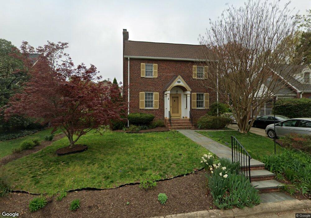
512 N Oakland St Arlington, VA 22203
Ashton Heights NeighborhoodEstimated Value: $1,310,543 - $1,562,000
3
Beds
3
Baths
3,500
Sq Ft
$397/Sq Ft
Est. Value
About This Home
This home is located at 512 N Oakland St, Arlington, VA 22203 and is currently estimated at $1,388,886, approximately $396 per square foot. 512 N Oakland St is a home located in Arlington County with nearby schools including Long Branch Elementary School, Thomas Jefferson Middle School, and Washington Liberty High School.
Ownership History
Date
Name
Owned For
Owner Type
Purchase Details
Closed on
May 31, 1995
Sold by
English Neal T
Bought by
Glassman Joseph L
Current Estimated Value
Home Financials for this Owner
Home Financials are based on the most recent Mortgage that was taken out on this home.
Original Mortgage
$203,150
Interest Rate
8.2%
Create a Home Valuation Report for This Property
The Home Valuation Report is an in-depth analysis detailing your home's value as well as a comparison with similar homes in the area
Home Values in the Area
Average Home Value in this Area
Purchase History
| Date | Buyer | Sale Price | Title Company |
|---|---|---|---|
| Glassman Joseph L | $260,000 | -- |
Source: Public Records
Mortgage History
| Date | Status | Borrower | Loan Amount |
|---|---|---|---|
| Closed | Glassman Joseph L | $203,150 | |
| Closed | Glassman Joseph L | $30,850 |
Source: Public Records
Tax History Compared to Growth
Tax History
| Year | Tax Paid | Tax Assessment Tax Assessment Total Assessment is a certain percentage of the fair market value that is determined by local assessors to be the total taxable value of land and additions on the property. | Land | Improvement |
|---|---|---|---|---|
| 2025 | $11,383 | $1,101,900 | $905,400 | $196,500 |
| 2024 | $11,140 | $1,078,400 | $890,400 | $188,000 |
| 2023 | $11,124 | $1,080,000 | $890,400 | $189,600 |
| 2022 | $10,644 | $1,033,400 | $840,400 | $193,000 |
| 2021 | $10,209 | $991,200 | $806,900 | $184,300 |
| 2020 | $9,417 | $917,800 | $742,500 | $175,300 |
| 2019 | $9,217 | $898,300 | $717,800 | $180,500 |
| 2018 | $8,795 | $874,300 | $668,300 | $206,000 |
| 2017 | $8,546 | $849,500 | $643,500 | $206,000 |
| 2016 | $8,246 | $832,100 | $623,700 | $208,400 |
| 2015 | $7,795 | $782,600 | $574,200 | $208,400 |
| 2014 | $7,499 | $752,900 | $544,500 | $208,400 |
Source: Public Records
Map
Nearby Homes
- 820 N Pollard St Unit 914
- 820 N Pollard St Unit 810
- 820 N Pollard St Unit 915
- 3500 7th St N
- 629 N Lincoln St
- 632 N Kenmore St
- 630 N Kenmore St
- 880 N Pollard St Unit 923
- 880 N Pollard St Unit 224
- 4141 N Henderson Rd Unit 313
- 4141 N Henderson Rd Unit 303
- 4141 N Henderson Rd Unit 1002
- 4141 N Henderson Rd Unit 107
- 4141 N Henderson Rd Unit 809
- 4141 N Henderson Rd Unit 511
- 3835 9th St N Unit 801E
- 3835 9th St N Unit 1001W
- 502 N Jackson St
- 888 N Quincy St Unit 2008
- 3800 Fairfax Dr Unit 808
- 518 N Oakland St
- 509 N Oxford St
- 505 N Oxford St
- 520 N Oakland St
- 513 N Oxford St
- 501 N Oxford St
- 501 N Oakland St
- 515 N Oakland St
- 517 N Oxford St
- 519 N Oakland St
- 526 N Oakland St
- 426 N Oakland St
- 523 N Oakland St
- 423 N Oakland St
- 521 N Oxford St
- 508 N Oxford St
- 530 N Oakland St
- 420 N Oakland St
- 512 N Oxford St
- 502 N Norwood St