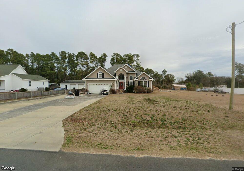
512 Pearson Cir Newport, NC 28570
Estimated Value: $468,374 - $582,000
3
Beds
3
Baths
2,510
Sq Ft
$209/Sq Ft
Est. Value
About This Home
This home is located at 512 Pearson Cir, Newport, NC 28570 and is currently estimated at $525,344, approximately $209 per square foot. 512 Pearson Cir is a home located in Carteret County with nearby schools including Bogue Sound Elementary School, Broad Creek Middle School, and Croatan High School.
Ownership History
Date
Name
Owned For
Owner Type
Purchase Details
Closed on
Nov 28, 2006
Sold by
Combs David A and Combs Mary K
Bought by
Rose James J and Rose Cynthia M
Current Estimated Value
Home Financials for this Owner
Home Financials are based on the most recent Mortgage that was taken out on this home.
Original Mortgage
$76,500
Outstanding Balance
$48,074
Interest Rate
7.25%
Mortgage Type
Unknown
Estimated Equity
$477,271
Purchase Details
Closed on
Jan 19, 2005
Sold by
Steish Systems Inc
Bought by
Combs David A and Combs Mary K
Create a Home Valuation Report for This Property
The Home Valuation Report is an in-depth analysis detailing your home's value as well as a comparison with similar homes in the area
Home Values in the Area
Average Home Value in this Area
Purchase History
| Date | Buyer | Sale Price | Title Company |
|---|---|---|---|
| Rose James J | $85,000 | None Available | |
| Combs David A | $74,000 | None Available |
Source: Public Records
Mortgage History
| Date | Status | Borrower | Loan Amount |
|---|---|---|---|
| Open | Rose James J | $76,500 |
Source: Public Records
Tax History Compared to Growth
Tax History
| Year | Tax Paid | Tax Assessment Tax Assessment Total Assessment is a certain percentage of the fair market value that is determined by local assessors to be the total taxable value of land and additions on the property. | Land | Improvement |
|---|---|---|---|---|
| 2025 | $1,408 | $474,357 | $59,392 | $414,965 |
| 2024 | $1,136 | $280,946 | $43,560 | $237,386 |
| 2023 | $1,210 | $280,946 | $43,560 | $237,386 |
| 2022 | $1,187 | $280,946 | $43,560 | $237,386 |
| 2021 | $1,139 | $280,946 | $43,560 | $237,386 |
| 2020 | $1,147 | $280,946 | $43,560 | $237,386 |
| 2019 | $1,296 | $286,204 | $43,560 | $242,644 |
| 2017 | $1,296 | $286,204 | $43,560 | $242,644 |
| 2016 | $1,296 | $286,204 | $43,560 | $242,644 |
| 2015 | $1,210 | $286,204 | $43,560 | $242,644 |
| 2014 | $1,096 | $300,403 | $48,300 | $252,103 |
Source: Public Records
Map
Nearby Homes
- 444 Pearson Cir
- 128 Creek Bluff Rd
- 600 Pearson Cir
- 264 Pearson Cir
- 124 Creek Bluff Rd
- 114 Creek Bluff Rd
- 107 Creek Bluff Rd
- 204 Junius Dr
- 108 Henderson Dr
- 111 Key Ln W
- 109 Pelican Dr
- 275 Salty Shores Rd
- 112 C St
- 147 Salty Shores Point
- 3387 Highway 24
- 680 Broad Creek Loop Rd
- 151 Charles St
- 142 Sunny Point Ln
- 137 Skipper Ct
- 163 Pine Crest Dr
- 518 Pearson Cir
- 500 Pearson Cir
- 526 Pearson Cir
- 527 Pearson Cir
- 530 Pearson Cir
- 430 Pearson Cir
- 534 Pearson Cir
- 483 Pearson Cir
- 420 Pearson Cir
- 540 Pearson Cir
- 406 & 410 Pearson Cir
- 472 Pearson Cir
- 406 Pearson Cir
- 546 Pearson Cir
- 400 Pearson Cir
- 134 Creek Bluff Rd
- 550 Pearson Cir
- 441 Pearson Cir
- 447 Pearson Cir
- 425 Pearson Cir