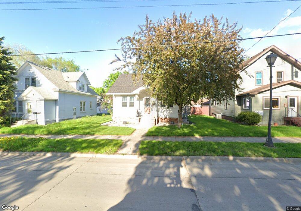
512 Range St Unit 512 Range Street North Mankato, MN 56003
Estimated Value: $236,000 - $263,142
3
Beds
1
Bath
1,193
Sq Ft
$207/Sq Ft
Est. Value
About This Home
This home is located at 512 Range St Unit 512 Range Street, North Mankato, MN 56003 and is currently estimated at $247,536, approximately $207 per square foot. 512 Range St Unit 512 Range Street is a home located in Nicollet County with nearby schools including Monroe Elementary School, Dakota Meadows Middle School, and Mankato West Senior High School.
Ownership History
Date
Name
Owned For
Owner Type
Purchase Details
Closed on
Apr 5, 2016
Sold by
Bardusch Mark
Bought by
Lietha Travis
Current Estimated Value
Home Financials for this Owner
Home Financials are based on the most recent Mortgage that was taken out on this home.
Original Mortgage
$124,900
Outstanding Balance
$99,323
Interest Rate
3.71%
Estimated Equity
$148,213
Purchase Details
Closed on
Aug 1, 2013
Sold by
Elston Gayle A
Bought by
Bardusch Mark C
Home Financials for this Owner
Home Financials are based on the most recent Mortgage that was taken out on this home.
Original Mortgage
$95,625
Interest Rate
4.25%
Create a Home Valuation Report for This Property
The Home Valuation Report is an in-depth analysis detailing your home's value as well as a comparison with similar homes in the area
Home Values in the Area
Average Home Value in this Area
Purchase History
| Date | Buyer | Sale Price | Title Company |
|---|---|---|---|
| Lietha Travis | $124,900 | -- | |
| Bardusch Mark C | $127,500 | -- |
Source: Public Records
Mortgage History
| Date | Status | Borrower | Loan Amount |
|---|---|---|---|
| Open | Lietha Travis | $124,900 | |
| Previous Owner | Bardusch Mark C | $95,625 |
Source: Public Records
Tax History Compared to Growth
Tax History
| Year | Tax Paid | Tax Assessment Tax Assessment Total Assessment is a certain percentage of the fair market value that is determined by local assessors to be the total taxable value of land and additions on the property. | Land | Improvement |
|---|---|---|---|---|
| 2025 | $2,642 | $229,600 | $36,000 | $193,600 |
| 2024 | $2,478 | $229,600 | $36,000 | $193,600 |
| 2023 | $2,294 | $207,400 | $36,000 | $171,400 |
| 2022 | $1,950 | $193,500 | $36,000 | $157,500 |
| 2021 | $1,940 | $154,500 | $28,400 | $126,100 |
| 2020 | $1,746 | $149,500 | $28,400 | $121,100 |
| 2019 | $1,678 | $139,400 | $28,400 | $111,000 |
| 2016 | $1,714 | $0 | $0 | $0 |
| 2015 | -- | $0 | $0 | $0 |
| 2011 | -- | $0 | $0 | $0 |
Source: Public Records
Map
Nearby Homes
- 245 W Wheeler Ave
- 725 725 Wall St
- 512 Page Ave
- 544 Page Ave
- 538 538 Belgrade Ave
- 541 541 Nicollet Ave
- 0 Outlot A Block 1 Unit 7031909
- 546 546 Ave S
- 954 954 Range St
- 420 Mc Kinley Ave
- 420 Mckinley Ave
- 217 E Spring St
- 719 Page Ave
- 206 206 E Elm St
- 726 Garfield Ave
- 314 314 E Walnut St
- 723 723 Nicollet Ave
- 723 Nicollet Ave
- 109 109 S 4th St
- 712 N Broad St