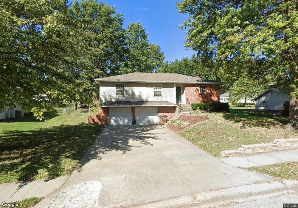
512 S Adams St Raymore, MO 64083
Estimated Value: $279,020 - $294,000
3
Beds
1
Bath
1,234
Sq Ft
$232/Sq Ft
Est. Value
About This Home
This home is located at 512 S Adams St, Raymore, MO 64083 and is currently estimated at $286,005, approximately $231 per square foot. 512 S Adams St is a home located in Cass County with nearby schools including Raymore Elementary School, Raymore-Peculiar East Middle School, and Raymore-Peculiar Senior High School.
Ownership History
Date
Name
Owned For
Owner Type
Purchase Details
Closed on
Jun 19, 2020
Sold by
Skaggs Michael N and Skaggs Richelle A
Bought by
Skaggs Michael N and Skaggs Richelle A
Current Estimated Value
Home Financials for this Owner
Home Financials are based on the most recent Mortgage that was taken out on this home.
Original Mortgage
$196,377
Outstanding Balance
$173,302
Interest Rate
3.2%
Mortgage Type
FHA
Estimated Equity
$112,703
Create a Home Valuation Report for This Property
The Home Valuation Report is an in-depth analysis detailing your home's value as well as a comparison with similar homes in the area
Home Values in the Area
Average Home Value in this Area
Purchase History
| Date | Buyer | Sale Price | Title Company |
|---|---|---|---|
| Skaggs Michael N | -- | None Available | |
| Skaggs Michael N | -- | Alliance Nationwide Ttl Agcy |
Source: Public Records
Mortgage History
| Date | Status | Borrower | Loan Amount |
|---|---|---|---|
| Open | Skaggs Michael N | $196,377 |
Source: Public Records
Tax History
| Year | Tax Paid | Tax Assessment Tax Assessment Total Assessment is a certain percentage of the fair market value that is determined by local assessors to be the total taxable value of land and additions on the property. | Land | Improvement |
|---|---|---|---|---|
| 2025 | $2,458 | $33,590 | $4,070 | $29,520 |
| 2024 | $2,458 | $30,210 | $3,700 | $26,510 |
| 2023 | $2,455 | $30,210 | $3,700 | $26,510 |
| 2022 | $2,216 | $27,090 | $3,700 | $23,390 |
| 2021 | $2,217 | $27,090 | $3,700 | $23,390 |
| 2020 | $2,187 | $26,260 | $3,700 | $22,560 |
| 2019 | $2,112 | $26,260 | $3,700 | $22,560 |
| 2018 | $1,956 | $23,490 | $2,960 | $20,530 |
| 2017 | $1,724 | $23,490 | $2,960 | $20,530 |
| 2016 | $1,724 | $21,490 | $2,960 | $18,530 |
| 2015 | $1,725 | $21,490 | $2,960 | $18,530 |
| 2014 | $1,726 | $21,490 | $2,960 | $18,530 |
| 2013 | -- | $21,490 | $2,960 | $18,530 |
Source: Public Records
Map
Nearby Homes
- 506 S Adams St
- 605 S Franklin St
- 503 S Harrison Ave
- 405 S Monroe St
- 709 Derby St
- 211 S Franklin St
- 600 W Buena Vista Dr
- 305 E Olive St
- 804 S Washington St
- 204 N Pointe Ln
- 222 N Madison St
- 219 Pointe Ln
- 221 N Pointe Ln
- 528 S Saturn Dr
- 515 S Saturn Dr
- 713 S Sunset Ln
- 720 Sandpiper St
- 702 Twilight Ct
- 108 Rainbow Cir
- 901 W Lucy Webb Rd
- 514 S Adams St
- 510 S Adams St
- 516 S Adams St
- 515 S Madison St
- 511 S Madison St
- 517 S Adams St
- 515 S Adams St
- 508 S Jefferson St
- 509 S Madison St
- 517 S Madison St
- 518 S Adams St
- 508 S Adams St
- 519 S Adams St
- 513 S Adams St
- 507 S Jefferson St
- 521 S Adams St
- 507 S Madison St
- 519 S Madison St
- 511 S Adams St
- 506 S Jefferson St
Your Personal Tour Guide
Ask me questions while you tour the home.