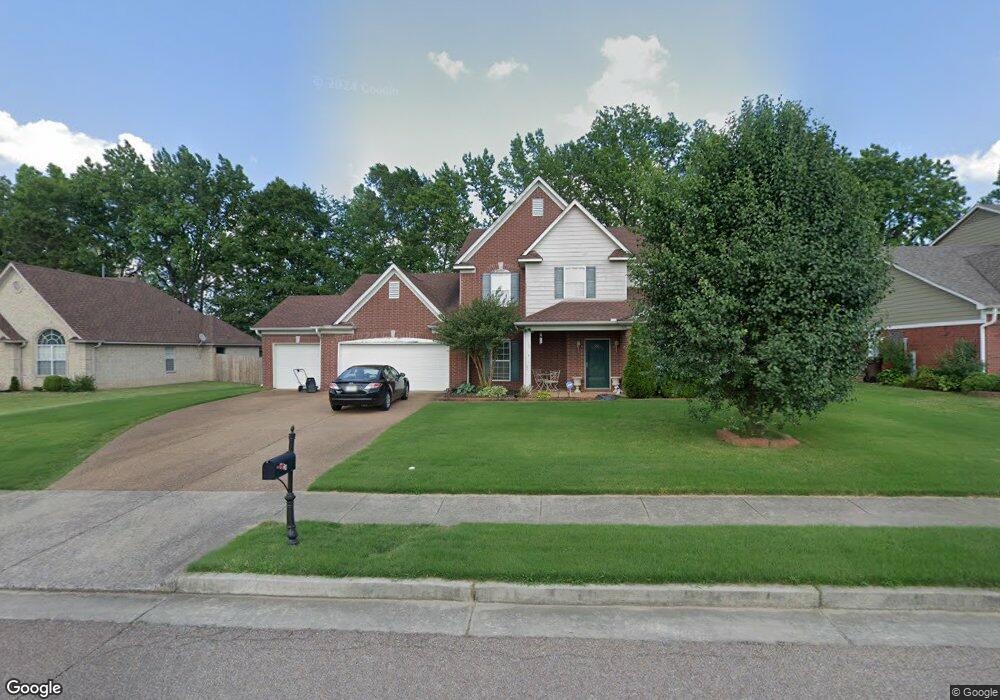
5124 Misty River Rd Memphis, TN 38135
Estimated Value: $386,000 - $435,000
4
Beds
3
Baths
3,317
Sq Ft
$123/Sq Ft
Est. Value
About This Home
This home is located at 5124 Misty River Rd, Memphis, TN 38135 and is currently estimated at $408,786, approximately $123 per square foot. 5124 Misty River Rd is a home located in Shelby County with nearby schools including Rivercrest Elementary School, Bon Lin Middle School, and Bartlett High School.
Ownership History
Date
Name
Owned For
Owner Type
Purchase Details
Closed on
Aug 20, 2004
Sold by
Faxongillis Homes Inc
Bought by
Bullard Marlon R and Bullard Ramona G
Current Estimated Value
Home Financials for this Owner
Home Financials are based on the most recent Mortgage that was taken out on this home.
Original Mortgage
$210,702
Outstanding Balance
$104,207
Interest Rate
5.96%
Mortgage Type
VA
Estimated Equity
$304,579
Create a Home Valuation Report for This Property
The Home Valuation Report is an in-depth analysis detailing your home's value as well as a comparison with similar homes in the area
Home Values in the Area
Average Home Value in this Area
Purchase History
| Date | Buyer | Sale Price | Title Company |
|---|---|---|---|
| Bullard Marlon R | $218,515 | -- |
Source: Public Records
Mortgage History
| Date | Status | Borrower | Loan Amount |
|---|---|---|---|
| Open | Bullard Marlon R | $210,702 |
Source: Public Records
Tax History
| Year | Tax Paid | Tax Assessment Tax Assessment Total Assessment is a certain percentage of the fair market value that is determined by local assessors to be the total taxable value of land and additions on the property. | Land | Improvement |
|---|---|---|---|---|
| 2025 | $2,385 | $105,175 | $18,000 | $87,175 |
| 2024 | $2,385 | $70,350 | $12,200 | $58,150 |
| 2023 | $3,602 | $70,350 | $12,200 | $58,150 |
| 2022 | $3,602 | $70,350 | $12,200 | $58,150 |
| 2021 | $3,658 | $70,350 | $12,200 | $58,150 |
| 2020 | $3,287 | $55,900 | $12,200 | $43,700 |
| 2019 | $3,287 | $55,900 | $12,200 | $43,700 |
| 2018 | $3,287 | $55,900 | $12,200 | $43,700 |
| 2017 | $2,297 | $55,900 | $12,200 | $43,700 |
| 2016 | $2,089 | $47,800 | $0 | $0 |
| 2014 | $2,089 | $47,800 | $0 | $0 |
Source: Public Records
Map
Nearby Homes
- 5218 Jeffrey Keith Dr
- 4945 French Broad Cove
- 5186 Guffin Rd
- 5283 Beagle Trail
- 6172 Maggie Oaks Dr
- 4740 Wellsgate Point
- 6487 Wells Fields Cove
- 6910 Walker Farms Dr
- 4702 Molsonwood Dr
- 6003 Abigail Bluffs Cove
- 6344 Ferncrest Dr
- 4713 Ravencrest Cove N
- 6587 Carolot Ln
- 4493 Glenchase Dr
- 4450 Guinevere Ln
- 5172 Canebreak Cove
- 5023 Farmland Way
- 4998 Farmland Way
- 00004 Old Brownsville Rd
- 4360 Guinevere Ln
- 5116 Misty River Rd
- 5134 Misty River Rd
- 5121 Bluff Springs Dr
- 5125 Bluff Springs Dr
- 5106 Misty River Rd
- 5143 Creek Cove
- 5142 Misty River Rd
- 5125 Misty River Rd
- 5117 Misty River Rd
- 6455 Bending River Rd
- 5115 Bluff Springs Dr
- 5109 Misty River Rd
- 5096 Misty River Rd
- 5151 Creek Cove
- 5105 Bluff Springs Dr
- 6443 Bending River Rd
- 5150 Misty River Rd
- 5099 Misty River Rd
- 5100 Crest Cove
- 6464 Bending River Rd
Your Personal Tour Guide
Ask me questions while you tour the home.