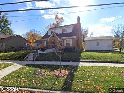
513 Locust St Elgin, IL 60123
Near West Elgin NeighborhoodEstimated Value: $257,000 - $308,000
3
Beds
2
Baths
1,465
Sq Ft
$193/Sq Ft
Est. Value
About This Home
This home is located at 513 Locust St, Elgin, IL 60123 and is currently estimated at $282,791, approximately $193 per square foot. 513 Locust St is a home located in Kane County with nearby schools including Washington Elementary School, Abbott Middle School, and Larkin High School.
Ownership History
Date
Name
Owned For
Owner Type
Purchase Details
Closed on
Jun 3, 2005
Sold by
Bilger Scott Alan and Bilger Yvonne Louise
Bought by
Gallegos Alfredo and Gallegos Rosa Maria
Current Estimated Value
Home Financials for this Owner
Home Financials are based on the most recent Mortgage that was taken out on this home.
Original Mortgage
$115,000
Interest Rate
5.87%
Mortgage Type
Purchase Money Mortgage
Create a Home Valuation Report for This Property
The Home Valuation Report is an in-depth analysis detailing your home's value as well as a comparison with similar homes in the area
Home Values in the Area
Average Home Value in this Area
Purchase History
| Date | Buyer | Sale Price | Title Company |
|---|---|---|---|
| Gallegos Alfredo | $180,000 | Chicago Title Insurance Comp |
Source: Public Records
Mortgage History
| Date | Status | Borrower | Loan Amount |
|---|---|---|---|
| Open | Gallegos Alfredo | $53,419 | |
| Closed | Gallegos Alfredo | $115,000 |
Source: Public Records
Tax History Compared to Growth
Tax History
| Year | Tax Paid | Tax Assessment Tax Assessment Total Assessment is a certain percentage of the fair market value that is determined by local assessors to be the total taxable value of land and additions on the property. | Land | Improvement |
|---|---|---|---|---|
| 2023 | $5,105 | $68,761 | $11,594 | $57,167 |
| 2022 | $4,847 | $62,698 | $10,572 | $52,126 |
| 2021 | $4,628 | $57,873 | $9,884 | $47,989 |
| 2020 | $4,492 | $55,249 | $9,436 | $45,813 |
| 2019 | $4,355 | $52,628 | $8,988 | $43,640 |
| 2018 | $4,174 | $48,218 | $8,467 | $39,751 |
| 2017 | $4,071 | $45,583 | $8,004 | $37,579 |
| 2016 | $3,870 | $42,289 | $7,426 | $34,863 |
| 2015 | -- | $38,762 | $6,807 | $31,955 |
| 2014 | -- | $38,283 | $6,723 | $31,560 |
| 2013 | -- | $39,292 | $6,900 | $32,392 |
Source: Public Records
Map
Nearby Homes
- 118 Jewett St
- 624 South St
- 30 Lynch St
- 333 Gertrude St Unit 333
- 214 S State St
- 230 S State St
- 115 N Union St
- 50 S Grove Ave Unit 510
- 114 Mallery Ave
- 3 National St Unit 3
- 5 National St Unit 5
- Lot 305 Wyrenwood Cir
- 7 National St Unit 7
- 133 S Grove Ave
- 216 Prairie St
- 179 S Grove Ave
- 187 S Grove Ave
- 324 Lawrence Ave
- 835 Oak St
- 422 Ryerson Ave