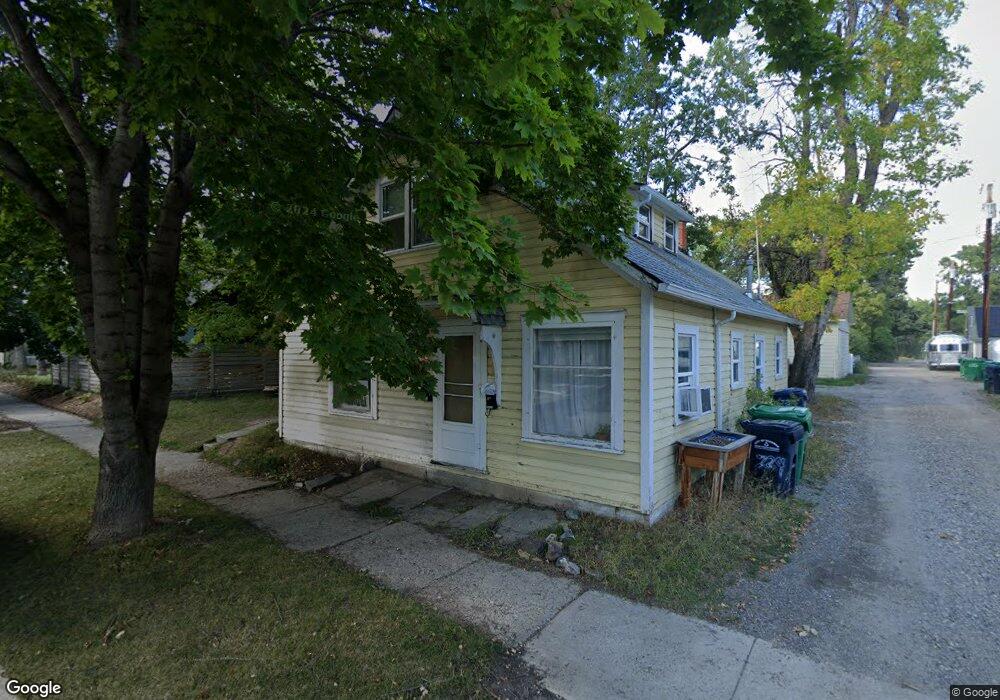
513 W Curtiss St Bozeman, MT 59715
Cooper Park NeighborhoodEstimated Value: $728,672 - $879,000
1
Bed
1
Bath
650
Sq Ft
$1,206/Sq Ft
Est. Value
About This Home
This home is located at 513 W Curtiss St, Bozeman, MT 59715 and is currently estimated at $783,668, approximately $1,205 per square foot. 513 W Curtiss St is a home located in Gallatin County with nearby schools including Irving Elementary School, Van Cortlandtville School, and Thomas Jefferson Elementary School.
Ownership History
Date
Name
Owned For
Owner Type
Purchase Details
Closed on
Aug 29, 2025
Sold by
Monahan Glenn E
Bought by
Genet Edward William Pou and Genet Mary Margaret
Current Estimated Value
Purchase Details
Closed on
Dec 27, 2016
Sold by
Lawrence Edward J and Lawrence Judith Kristine
Bought by
Lawrence Edward J and Lawrence Judith K
Purchase Details
Closed on
Dec 5, 2016
Sold by
Pazamin Carol A
Bought by
Lawrence Judith Kristine and Lawrence Edward J
Create a Home Valuation Report for This Property
The Home Valuation Report is an in-depth analysis detailing your home's value as well as a comparison with similar homes in the area
Home Values in the Area
Average Home Value in this Area
Purchase History
| Date | Buyer | Sale Price | Title Company |
|---|---|---|---|
| Genet Edward William Pou | -- | -- | |
| Lawrence Edward J | -- | First American Title Company | |
| Lawrence Judith Kristine | -- | First American Title Company |
Source: Public Records
Tax History Compared to Growth
Tax History
| Year | Tax Paid | Tax Assessment Tax Assessment Total Assessment is a certain percentage of the fair market value that is determined by local assessors to be the total taxable value of land and additions on the property. | Land | Improvement |
|---|---|---|---|---|
| 2025 | $2,646 | $599,000 | $0 | $0 |
| 2024 | $4,555 | $684,300 | $0 | $0 |
| 2023 | $4,403 | $684,300 | $0 | $0 |
| 2022 | $3,138 | $409,200 | $0 | $0 |
| 2021 | $3,462 | $409,200 | $0 | $0 |
| 2020 | $2,941 | $344,500 | $0 | $0 |
| 2019 | $3,008 | $344,500 | $0 | $0 |
| 2018 | $2,954 | $313,500 | $0 | $0 |
| 2017 | $2,762 | $313,500 | $0 | $0 |
| 2016 | $2,345 | $248,700 | $0 | $0 |
| 2015 | $2,347 | $248,700 | $0 | $0 |
| 2014 | $1,817 | $113,208 | $0 | $0 |
Source: Public Records
Map
Nearby Homes
- 516 W Olive St
- 425 W Olive St
- 221 S 7th Ave
- 418 W Babcock St
- 414 W Babcock St Unit 2
- 300 W Main St Unit G
- 300 W Main St Unit Q
- 401 S Grand Ave
- 507 S 8th Ave
- 622 & 624 S 8th
- 37 W Main St Unit A
- 5 W Mendenhall St Unit 414
- 5 W Mendenhall St Unit 510
- 5 W Mendenhall St Unit 410
- 5 W Mendenhall St Unit 415
- 1214 W Koch St
- 509 W Cleveland St
- 728 S Tracy Ave
- 420 N 6th Ave
- 5 Francham Trail