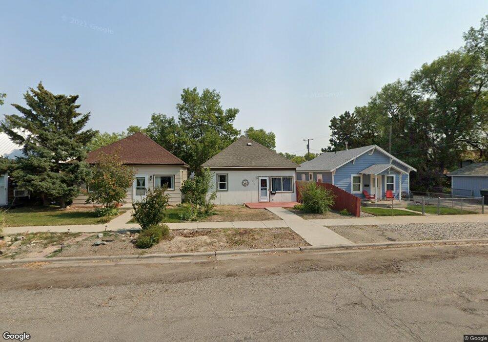
513 Wyoming Ave Laurel, MT 59044
Estimated Value: $166,180 - $252,000
2
Beds
1
Bath
720
Sq Ft
$290/Sq Ft
Est. Value
About This Home
This home is located at 513 Wyoming Ave, Laurel, MT 59044 and is currently estimated at $209,045, approximately $290 per square foot. 513 Wyoming Ave is a home located in Yellowstone County with nearby schools including Fred W. Graff School, West School, and Laurel Middle School.
Ownership History
Date
Name
Owned For
Owner Type
Purchase Details
Closed on
Jun 13, 2014
Sold by
Zimmerer Steve
Bought by
Sunfire Llc
Current Estimated Value
Purchase Details
Closed on
Jun 6, 2014
Sold by
First American Title Insurance
Bought by
Zimmerer Steve
Purchase Details
Closed on
Jun 13, 2006
Sold by
Lukenbach Lillian M
Bought by
Lukenbach Rodney
Home Financials for this Owner
Home Financials are based on the most recent Mortgage that was taken out on this home.
Original Mortgage
$53,623
Interest Rate
6.55%
Mortgage Type
New Conventional
Create a Home Valuation Report for This Property
The Home Valuation Report is an in-depth analysis detailing your home's value as well as a comparison with similar homes in the area
Home Values in the Area
Average Home Value in this Area
Purchase History
| Date | Buyer | Sale Price | Title Company |
|---|---|---|---|
| Sunfire Llc | -- | Chicago Title | |
| Zimmerer Steve | -- | None Available | |
| Lukenbach Rodney | -- | St |
Source: Public Records
Mortgage History
| Date | Status | Borrower | Loan Amount |
|---|---|---|---|
| Previous Owner | Lukenbach Rodney | $53,623 |
Source: Public Records
Tax History Compared to Growth
Tax History
| Year | Tax Paid | Tax Assessment Tax Assessment Total Assessment is a certain percentage of the fair market value that is determined by local assessors to be the total taxable value of land and additions on the property. | Land | Improvement |
|---|---|---|---|---|
| 2025 | $1,360 | $168,300 | $47,692 | $120,608 |
| 2024 | $1,360 | $137,600 | $30,825 | $106,775 |
| 2023 | $1,255 | $137,600 | $30,825 | $106,775 |
| 2022 | $838 | $100,400 | $0 | $0 |
| 2021 | $1,245 | $100,400 | $0 | $0 |
| 2020 | $920 | $91,500 | $0 | $0 |
| 2019 | $929 | $91,500 | $0 | $0 |
| 2018 | $867 | $81,200 | $0 | $0 |
| 2017 | $806 | $81,200 | $0 | $0 |
| 2016 | $862 | $89,500 | $0 | $0 |
| 2015 | $852 | $89,500 | $0 | $0 |
| 2014 | $716 | $38,690 | $0 | $0 |
Source: Public Records
Map
Nearby Homes
- 516 Pennsylvania Ave
- 717 E 5th, 506 Alder Ave
- 801 E 4th St
- 110 E 5th St
- 1006 Sunhaven Dr
- 518 Date Ave
- 1004 E 8th St
- 1008 Sunhaven Dr
- 1003 Montana Ave
- 802-816 Date Ave
- 1104 E 8th St
- 1108 E 8th St
- 810 Piper Loop
- 1115 Sunhaven Dr
- 116 4th Ave
- 109 E 12th St
- 211 Woodland Ave
- 403 Grandview Blvd
- 1336 Pennsylvania Ave
- 102 8th Ave Unit B