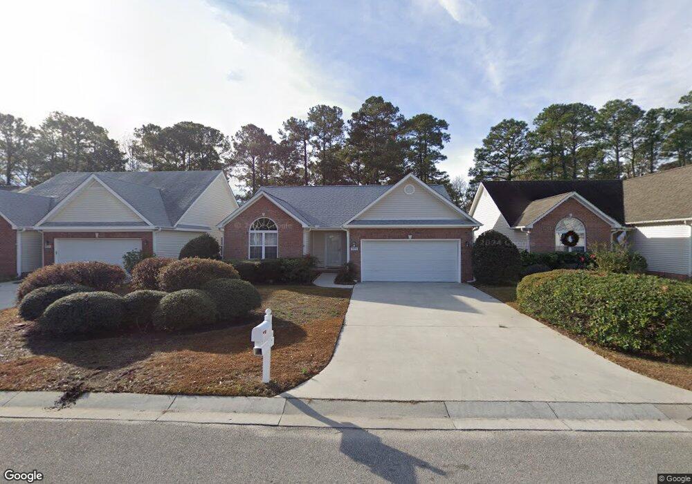
5133 Long Pointe Rd Wilmington, NC 28409
Estimated Value: $373,000 - $430,957
3
Beds
2
Baths
1,360
Sq Ft
$297/Sq Ft
Est. Value
About This Home
This home is located at 5133 Long Pointe Rd, Wilmington, NC 28409 and is currently estimated at $403,739, approximately $296 per square foot. 5133 Long Pointe Rd is a home located in New Hanover County with nearby schools including Pine Valley Elementary School, Myrtle Grove Middle School, and Eugene Ashley High School.
Ownership History
Date
Name
Owned For
Owner Type
Purchase Details
Closed on
Jul 29, 2014
Sold by
Logan John
Bought by
Booze Robert J
Current Estimated Value
Purchase Details
Closed on
Aug 3, 2005
Sold by
Genger Selena L
Bought by
Logan John
Purchase Details
Closed on
Oct 29, 2003
Sold by
Stevens Limited Llc
Bought by
Genger Selena L
Purchase Details
Closed on
Mar 1, 2002
Sold by
Baker Precythe Development Co
Bought by
Stevens Limited Llc
Purchase Details
Closed on
May 22, 1998
Sold by
B & D Development Corp
Bought by
Baker Precythe Development Co
Create a Home Valuation Report for This Property
The Home Valuation Report is an in-depth analysis detailing your home's value as well as a comparison with similar homes in the area
Home Values in the Area
Average Home Value in this Area
Purchase History
| Date | Buyer | Sale Price | Title Company |
|---|---|---|---|
| Booze Robert J | $175,000 | None Available | |
| Logan John | $205,000 | None Available | |
| Genger Selena L | $145,000 | -- | |
| Stevens Limited Llc | $132,000 | -- | |
| Baker Precythe Development Co | -- | -- |
Source: Public Records
Tax History
| Year | Tax Paid | Tax Assessment Tax Assessment Total Assessment is a certain percentage of the fair market value that is determined by local assessors to be the total taxable value of land and additions on the property. | Land | Improvement |
|---|---|---|---|---|
| 2025 | -- | $383,000 | $110,100 | $272,900 |
| 2023 | -- | $228,500 | $60,700 | $167,800 |
| 2022 | $0 | $228,500 | $60,700 | $167,800 |
| 2021 | $1,063 | $228,500 | $60,700 | $167,800 |
| 2020 | $1,063 | $168,000 | $44,000 | $124,000 |
| 2019 | $1,063 | $168,000 | $44,000 | $124,000 |
| 2018 | $1,063 | $168,000 | $44,000 | $124,000 |
| 2017 | $1,088 | $168,000 | $44,000 | $124,000 |
| 2016 | $1,109 | $160,100 | $44,000 | $116,100 |
| 2015 | $1,031 | $160,100 | $44,000 | $116,100 |
| 2014 | $1,013 | $160,100 | $44,000 | $116,100 |
Source: Public Records
Map
Nearby Homes
- 141 Mohican Trail
- 5117 Chalice Ln
- 5200 Woods Edge Rd
- 4641 Masonboro Loop Rd
- 4903 Trailing Vine Ln
- 142 Foxwood Ln
- 5904 Headsail Ct
- 5021 Out Island Dr
- 221 Friendly Ln
- 4953 Coronado Dr
- 134 Cherokee Trail
- 5225 Leisure Cir
- 4511 Masonboro Loop Rd
- 273 Foxwood Ln
- 229 Navaho Trail
- 4921 Crosswinds Dr
- 4809 W Grove Dr
- 101 Barton Oaks Dr
- 5014 Helms Port Ave
- 4245 Moorland Ln
- 5131 Long Pointe Rd
- 5135 Long Pointe Rd
- 5129 Long Pointe Rd
- 5137 Long Pointe Rd
- 5127 Long Pointe Rd
- 5139 Long Pointe Rd
- 5130 Long Pointe Rd
- 5128 Long Pointe Rd
- 5125 Long Pointe Rd
- 5134 Long Pointe Rd
- 5141 Long Pointe Rd
- 5126 Long Pointe Rd
- 5136 Long Pointe Rd
- 5123 Long Pointe Rd
- 5124 Long Pointe Rd
- 5138 Long Pointe Rd
- 5122 Long Pointe Rd
- 5140 Long Pointe Rd
- 5121 Long Pointe Rd
- 300 Hidden Valley Rd
Your Personal Tour Guide
Ask me questions while you tour the home.