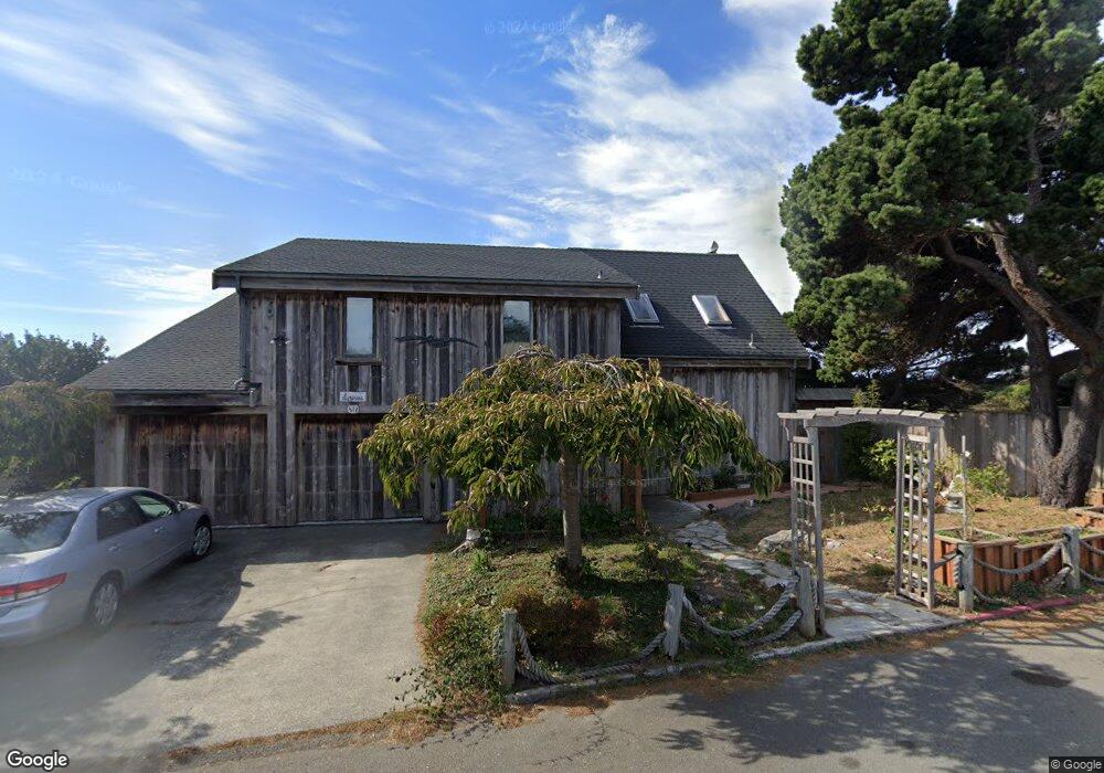
514 Ewing St Trinidad, CA 95570
Estimated Value: $855,459 - $1,150,000
2
Beds
3
Baths
2,328
Sq Ft
$425/Sq Ft
Est. Value
About This Home
This home is located at 514 Ewing St, Trinidad, CA 95570 and is currently estimated at $988,865, approximately $424 per square foot. 514 Ewing St is a home with nearby schools including Trinidad Elementary School and McKinleyville High School.
Ownership History
Date
Name
Owned For
Owner Type
Purchase Details
Closed on
Apr 20, 2018
Sold by
Lin Angela
Bought by
Lin Angela and Goldman David N
Current Estimated Value
Home Financials for this Owner
Home Financials are based on the most recent Mortgage that was taken out on this home.
Original Mortgage
$450,000
Outstanding Balance
$387,082
Interest Rate
4.45%
Mortgage Type
New Conventional
Estimated Equity
$601,783
Purchase Details
Closed on
Sep 9, 1998
Sold by
Lin Chi Wei and Lin Donna
Bought by
Lin Chi Wei and Lin Donna
Purchase Details
Closed on
Jul 2, 1998
Sold by
Dewitt Ralph D and Dewitt Ellen C
Bought by
Lin Chi Wei and Lin Donna
Home Financials for this Owner
Home Financials are based on the most recent Mortgage that was taken out on this home.
Original Mortgage
$190,000
Interest Rate
6.93%
Create a Home Valuation Report for This Property
The Home Valuation Report is an in-depth analysis detailing your home's value as well as a comparison with similar homes in the area
Purchase History
| Date | Buyer | Sale Price | Title Company |
|---|---|---|---|
| Lin Angela | -- | Placer Title Company | |
| Lin Chi Wei | -- | -- | |
| Lin Chi Wei | $380,000 | Fidelity National Title Co |
Source: Public Records
Mortgage History
| Date | Status | Borrower | Loan Amount |
|---|---|---|---|
| Open | Lin Angela | $450,000 | |
| Closed | Lin Chi Wei | $190,000 |
Source: Public Records
Tax History
| Year | Tax Paid | Tax Assessment Tax Assessment Total Assessment is a certain percentage of the fair market value that is determined by local assessors to be the total taxable value of land and additions on the property. | Land | Improvement |
|---|---|---|---|---|
| 2025 | $6,168 | $607,309 | $352,727 | $254,582 |
| 2024 | $6,168 | $595,402 | $345,811 | $249,591 |
| 2023 | $6,198 | $583,729 | $339,031 | $244,698 |
| 2022 | $6,146 | $572,284 | $332,384 | $239,900 |
| 2021 | $5,897 | $561,064 | $325,867 | $235,197 |
| 2020 | $6,008 | $555,312 | $322,526 | $232,786 |
| 2019 | $5,787 | $544,424 | $316,202 | $228,222 |
| 2018 | $5,642 | $533,750 | $310,002 | $223,748 |
| 2017 | $5,462 | $523,285 | $303,924 | $219,361 |
| 2016 | $5,364 | $513,025 | $297,965 | $215,060 |
| 2015 | -- | $505,320 | $293,490 | $211,830 |
| 2014 | -- | $495,422 | $287,741 | $207,681 |
Source: Public Records
Map
Nearby Homes
- 408 Wagner St
- 760 Stagecoach Rd
- 1120 Patricks Point Dr
- 1155 Patricks Point Dr
- 1167 Westhaven Dr N
- 1180 Fox Farm Rd
- 414 Highland Ave
- 675 8th Ave
- 801 6th Ave
- 3535 Patricks Point Dr
- 4373 Central Ave
- 3848 Dows Prairie Rd
- 1645 Prairie Hawke Ct
- 3220 Boeing Ave
- 3077 Sandpointe Dr
- 1126 Killdeer Rd
- 1896 Blake Rd
- 2973 Springer Dr
- 3024 Halfway Ave
- 1825 Dixie Ln
Your Personal Tour Guide
Ask me questions while you tour the home.