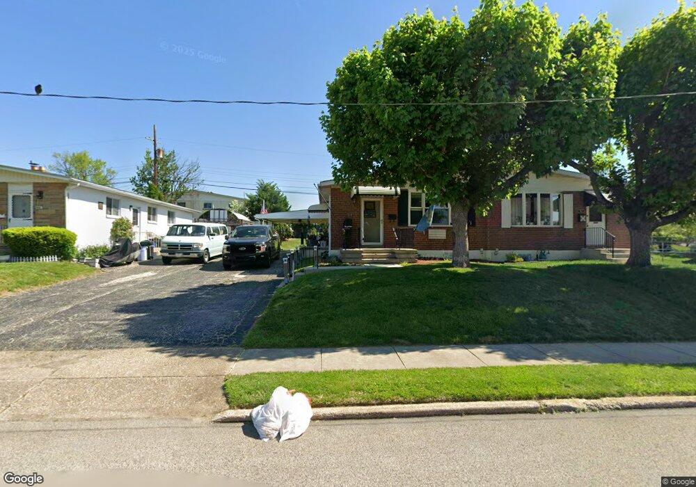
514 Palmer Rd Conshohocken, PA 19428
Estimated Value: $351,642 - $425,000
2
Beds
1
Bath
990
Sq Ft
$387/Sq Ft
Est. Value
About This Home
This home is located at 514 Palmer Rd, Conshohocken, PA 19428 and is currently estimated at $383,161, approximately $387 per square foot. 514 Palmer Rd is a home located in Montgomery County with nearby schools including Plymouth Elementary School, Colonial Elementary School, and Colonial Middle School.
Ownership History
Date
Name
Owned For
Owner Type
Purchase Details
Closed on
Apr 9, 2008
Sold by
Dean Constance
Bought by
Riley Diane and Dean Constance
Current Estimated Value
Purchase Details
Closed on
Feb 23, 2001
Sold by
Dean Constance and Tryson William P
Bought by
Dean Paul and Dean Constance
Purchase Details
Closed on
Aug 9, 1999
Sold by
Tryson Nadia P and Tryson William P
Bought by
Dean Constance and Tryson William P
Purchase Details
Closed on
Apr 26, 1999
Sold by
Tryson William P and Tryson Richard L
Bought by
Tryson Leon P and Tryson Nadia P
Purchase Details
Closed on
Jul 18, 1997
Sold by
Tryson Leon P and Tryson Nadia P
Bought by
Tryson William P and Tryson Richard L
Create a Home Valuation Report for This Property
The Home Valuation Report is an in-depth analysis detailing your home's value as well as a comparison with similar homes in the area
Home Values in the Area
Average Home Value in this Area
Purchase History
| Date | Buyer | Sale Price | Title Company |
|---|---|---|---|
| Riley Diane | -- | None Available | |
| Dean Paul | -- | -- | |
| Dean Constance | -- | -- | |
| Tryson Leon P | -- | -- | |
| Tryson William P | -- | -- |
Source: Public Records
Tax History Compared to Growth
Tax History
| Year | Tax Paid | Tax Assessment Tax Assessment Total Assessment is a certain percentage of the fair market value that is determined by local assessors to be the total taxable value of land and additions on the property. | Land | Improvement |
|---|---|---|---|---|
| 2025 | $3,254 | $99,140 | $44,810 | $54,330 |
| 2024 | $3,254 | $99,140 | $44,810 | $54,330 |
| 2023 | $3,128 | $99,140 | $44,810 | $54,330 |
| 2022 | $3,056 | $99,140 | $44,810 | $54,330 |
| 2021 | $2,955 | $99,140 | $44,810 | $54,330 |
| 2020 | $2,853 | $99,140 | $44,810 | $54,330 |
| 2019 | $2,769 | $99,140 | $44,810 | $54,330 |
| 2018 | $590 | $99,140 | $44,810 | $54,330 |
| 2017 | $2,668 | $99,140 | $44,810 | $54,330 |
| 2016 | $2,629 | $99,140 | $44,810 | $54,330 |
| 2015 | $2,465 | $99,140 | $44,810 | $54,330 |
| 2014 | $2,465 | $99,140 | $44,810 | $54,330 |
Source: Public Records
Map
Nearby Homes
- 1211 Woodside Rd
- 461 W 11th Ave
- 121 Scarlet Dr
- 133 Sutcliffe Ln
- 1004 Aspen Ct
- 219 W 11th Ave
- 345 W 6th Ave
- 140 W 11th Ave
- 635 Wood St
- 326 W 4th Ave
- 1408 Butler Pike
- 1410 Butler Pike
- 33 E 8th Ave Unit 55
- 215 W 3rd Ave Unit 2
- 453 Old Elm St
- 463 New Elm St
- 1705 Harmon Rd
- 148 W 1st Ave
- 222 E 7th Ave
- 253 E 10th Ave