Estimated Value: $241,000 - $367,892
5
Beds
5
Baths
1,534
Sq Ft
$206/Sq Ft
Est. Value
About This Home
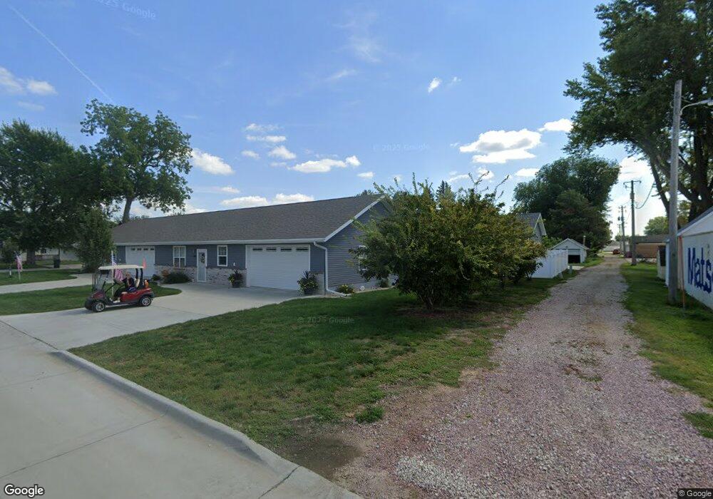
This home is located at 515 Barnard St, Sloan, IA 51055 and is currently estimated at $316,223, approximately $206 per square foot. 515 Barnard St is a home with nearby schools including Westwood Elementary School and Westwood High School.
Ownership History
Date
Name
Owned For
Owner Type
Purchase Details
Closed on
Apr 25, 2022
Sold by
Booth Dennis M and Booth Candace J
Bought by
Pike Rebecca
Current Estimated Value
Home Financials for this Owner
Home Financials are based on the most recent Mortgage that was taken out on this home.
Original Mortgage
$230,000
Outstanding Balance
$217,898
Interest Rate
5.11%
Mortgage Type
New Conventional
Estimated Equity
$98,325
Purchase Details
Closed on
May 16, 2020
Sold by
Mareau Steven M and Mareau Michele K
Bought by
Booth Dennis M and Booth Candace J
Home Financials for this Owner
Home Financials are based on the most recent Mortgage that was taken out on this home.
Original Mortgage
$235,000
Interest Rate
3.3%
Mortgage Type
New Conventional
Create a Home Valuation Report for This Property
The Home Valuation Report is an in-depth analysis detailing your home's value as well as a comparison with similar homes in the area
Home Values in the Area
Average Home Value in this Area
Purchase History
| Date | Buyer | Sale Price | Title Company |
|---|---|---|---|
| Pike Rebecca | $287,500 | Fischer & Bouslog Pc | |
| Booth Dennis M | $310,000 | None Available |
Source: Public Records
Mortgage History
| Date | Status | Borrower | Loan Amount |
|---|---|---|---|
| Open | Pike Rebecca | $230,000 | |
| Previous Owner | Booth Dennis M | $235,000 |
Source: Public Records
Tax History Compared to Growth
Tax History
| Year | Tax Paid | Tax Assessment Tax Assessment Total Assessment is a certain percentage of the fair market value that is determined by local assessors to be the total taxable value of land and additions on the property. | Land | Improvement |
|---|---|---|---|---|
| 2025 | $998 | $446,880 | $8,820 | $438,060 |
| 2024 | $998 | $396,880 | $8,750 | $388,130 |
| 2023 | -- | $87,280 | $8,750 | $78,530 |
| 2022 | $134 | $8,750 | $8,750 | $0 |
| 2021 | $134 | $8,750 | $8,750 | $0 |
| 2020 | $1,514 | $99,790 | $9,360 | $90,430 |
Source: Public Records
Map
Nearby Homes
- 511 5th St
- 521 Beall St
- 409 Elm St
- 301 Cedar St
- 2009 325th St
- 3003 Cass Ave
- 00 120th St
- 12724 Highway K42
- 401 Main St
- 0 Alder Ave Unit NOC6331681
- TBD 280th St Unit Lot 4
- 15260 Elder Ave
- 308 Whittier St
- 2718 Grundy Ave
- 417 Blair St
- 409 Plymouth St
- 325 Salem St
- 2216 Old Highway 141
- 320 Maple St
- TBD 230th St