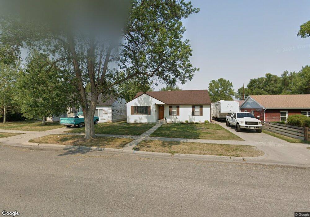
515 E 6th St Laurel, MT 59044
Estimated Value: $238,000 - $286,000
3
Beds
1
Bath
1,204
Sq Ft
$219/Sq Ft
Est. Value
About This Home
This home is located at 515 E 6th St, Laurel, MT 59044 and is currently estimated at $263,738, approximately $219 per square foot. 515 E 6th St is a home located in Yellowstone County with nearby schools including Fred W. Graff School, West School, and Laurel Middle School.
Ownership History
Date
Name
Owned For
Owner Type
Purchase Details
Closed on
Dec 10, 2021
Sold by
Quale Jon C and Quale Lisa A
Bought by
Barr Kyle J and Barr Emily N
Current Estimated Value
Home Financials for this Owner
Home Financials are based on the most recent Mortgage that was taken out on this home.
Original Mortgage
$181,818
Outstanding Balance
$166,606
Interest Rate
3.14%
Mortgage Type
New Conventional
Estimated Equity
$97,132
Purchase Details
Closed on
Nov 17, 2017
Sold by
Frickel Lonny R and Riesinger Karla R
Bought by
Quale Jon C and Quale Lisa A
Create a Home Valuation Report for This Property
The Home Valuation Report is an in-depth analysis detailing your home's value as well as a comparison with similar homes in the area
Home Values in the Area
Average Home Value in this Area
Purchase History
| Date | Buyer | Sale Price | Title Company |
|---|---|---|---|
| Barr Kyle J | -- | First Montana Title Company | |
| Quale Jon C | -- | American Title And Escrow |
Source: Public Records
Mortgage History
| Date | Status | Borrower | Loan Amount |
|---|---|---|---|
| Open | Barr Kyle J | $181,818 |
Source: Public Records
Tax History
| Year | Tax Paid | Tax Assessment Tax Assessment Total Assessment is a certain percentage of the fair market value that is determined by local assessors to be the total taxable value of land and additions on the property. | Land | Improvement |
|---|---|---|---|---|
| 2025 | $2,211 | $259,000 | $58,501 | $200,499 |
| 2024 | $2,211 | $220,400 | $38,046 | $182,354 |
| 2023 | $2,043 | $220,400 | $38,046 | $182,354 |
| 2022 | $1,751 | $177,100 | $0 | $0 |
| 2021 | $1,718 | $171,400 | $0 | $0 |
| 2020 | $1,650 | $164,000 | $0 | $0 |
| 2019 | $1,668 | $164,000 | $0 | $0 |
| 2018 | $1,557 | $145,900 | $0 | $0 |
| 2017 | $1,437 | $144,700 | $0 | $0 |
| 2016 | $430 | $143,500 | $0 | $0 |
| 2015 | $427 | $143,500 | $0 | $0 |
| 2014 | $372 | $59,201 | $0 | $0 |
Source: Public Records
Map
Nearby Homes
- 601 E 5th St
- 516 Pennsylvania Ave
- 414 Wyoming Ave
- 717 E 5th St
- 717 E 5th, 506 Alder Ave
- 801 E 4th St
- 110 E 5th St
- 605 Date Ave
- 1104 E 8th St
- 1108 E 8th St
- 603 5th Ave
- 116 4th Ave
- 1031 Fir Ave
- 319 6th Ave
- 211 Woodland Ave
- 310 (and 814 w 4) 8th Ave
- 409 Maple Ave
- 1319 Valley Dr
- 102 8th Ave Unit B
- 120 Forrest Ave
- 511 E 6th St
- 519 E 6th St
- 610 Washington Ave
- 507 E 6th St
- 520 Washington Ave
- 611 Wyoming Ave
- 501 E 6th St
- 605 Washington Ave
- 601 E 6th St
- 620 Washington Ave
- 516 Washington Ave
- 519 Wyoming Ave
- 517 Wyoming Ave
- 605 E 6th St
- 504 E 7th St
- 515 Wyoming Ave
- 611 Washington Ave
- 512 Washington Ave
- 619 Washington Ave
- 513 Wyoming Ave
Your Personal Tour Guide
Ask me questions while you tour the home.