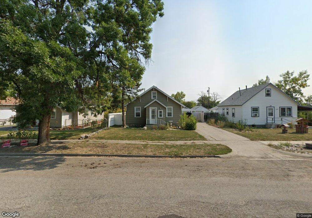
515 Fir Ave Laurel, MT 59044
Estimated Value: $271,000 - $297,000
4
Beds
2
Baths
1,456
Sq Ft
$197/Sq Ft
Est. Value
About This Home
This home is located at 515 Fir Ave, Laurel, MT 59044 and is currently estimated at $286,454, approximately $196 per square foot. 515 Fir Ave is a home located in Yellowstone County with nearby schools including Fred W. Graff School, West School, and Laurel Middle School.
Ownership History
Date
Name
Owned For
Owner Type
Purchase Details
Closed on
Jun 10, 2016
Sold by
Miskey Rebekah
Bought by
Thurman Mitchell R
Current Estimated Value
Home Financials for this Owner
Home Financials are based on the most recent Mortgage that was taken out on this home.
Original Mortgage
$163,483
Outstanding Balance
$129,817
Interest Rate
3.5%
Mortgage Type
FHA
Estimated Equity
$156,637
Purchase Details
Closed on
Apr 21, 2009
Sold by
Miskey John
Bought by
Miskey Rebekah
Purchase Details
Closed on
Jul 6, 2005
Sold by
Dove Richard E and Dove Arlys A
Bought by
Miskey John and Miskey Rebekah
Home Financials for this Owner
Home Financials are based on the most recent Mortgage that was taken out on this home.
Original Mortgage
$96,438
Interest Rate
5.58%
Mortgage Type
FHA
Create a Home Valuation Report for This Property
The Home Valuation Report is an in-depth analysis detailing your home's value as well as a comparison with similar homes in the area
Home Values in the Area
Average Home Value in this Area
Purchase History
| Date | Buyer | Sale Price | Title Company |
|---|---|---|---|
| Thurman Mitchell R | -- | First Montana Title | |
| Miskey Rebekah | -- | None Available | |
| Miskey John | -- | St |
Source: Public Records
Mortgage History
| Date | Status | Borrower | Loan Amount |
|---|---|---|---|
| Open | Thurman Mitchell R | $163,483 | |
| Previous Owner | Miskey John | $96,438 |
Source: Public Records
Tax History Compared to Growth
Tax History
| Year | Tax Paid | Tax Assessment Tax Assessment Total Assessment is a certain percentage of the fair market value that is determined by local assessors to be the total taxable value of land and additions on the property. | Land | Improvement |
|---|---|---|---|---|
| 2025 | $2,240 | $265,200 | $56,449 | $208,751 |
| 2024 | $2,240 | $227,000 | $36,672 | $190,328 |
| 2023 | $2,067 | $227,000 | $36,672 | $190,328 |
| 2022 | $1,753 | $180,800 | $28,179 | $152,621 |
| 2021 | $1,767 | $180,800 | $0 | $0 |
| 2020 | $1,669 | $169,200 | $0 | $0 |
| 2019 | $1,676 | $169,200 | $0 | $0 |
| 2018 | $1,541 | $146,400 | $0 | $0 |
| 2017 | $1,246 | $146,400 | $0 | $0 |
| 2016 | $1,305 | $133,600 | $0 | $0 |
| 2015 | $1,290 | $133,600 | $0 | $0 |
| 2014 | $1,105 | $58,882 | $0 | $0 |
Source: Public Records
Map
Nearby Homes
- 611 Elm Ave
- 1115 Sunhaven Dr
- 518 Date Ave
- 1108 E 8th St
- 1104 E 8th St
- 1008 Sunhaven Dr
- 1006 Sunhaven Dr
- 810 Piper Loop
- 1004 E 8th St
- 802-816 Date Ave
- 801 E 4th St
- 717 E 5th, 506 Alder Ave
- 1805 E Maryland Ln
- 516 Pennsylvania Ave
- 110 E 5th St
- 1003 Montana Ave
- 1718 Pinyon Dr
- 109 E 12th St
- 1336 Pennsylvania Ave
- 116 4th Ave