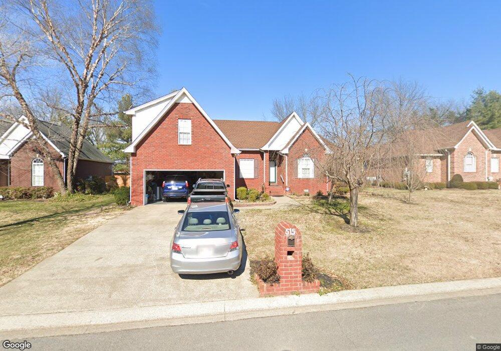
515 Forrest Pointe Dr Murfreesboro, TN 37130
Estimated Value: $402,346 - $478,000
--
Bed
2
Baths
2,220
Sq Ft
$198/Sq Ft
Est. Value
About This Home
This home is located at 515 Forrest Pointe Dr, Murfreesboro, TN 37130 and is currently estimated at $439,837, approximately $198 per square foot. 515 Forrest Pointe Dr is a home located in Rutherford County with nearby schools including Black Fox Elementary School, Christiana Middle School, and Riverdale High School.
Ownership History
Date
Name
Owned For
Owner Type
Purchase Details
Closed on
Feb 9, 1998
Sold by
Khammpouvong Heuangssack E
Bought by
Et Khamphouvong Heuangsack
Current Estimated Value
Purchase Details
Closed on
Aug 5, 1997
Sold by
Richton Homes Inc
Bought by
Khammpouvong Heuangssack E
Purchase Details
Closed on
Jul 17, 1996
Sold by
Forrest Partnership
Bought by
Richton Homes Inc
Create a Home Valuation Report for This Property
The Home Valuation Report is an in-depth analysis detailing your home's value as well as a comparison with similar homes in the area
Home Values in the Area
Average Home Value in this Area
Purchase History
| Date | Buyer | Sale Price | Title Company |
|---|---|---|---|
| Et Khamphouvong Heuangsack | -- | -- | |
| Khammpouvong Heuangssack E | $134,000 | -- | |
| Richton Homes Inc | $16,600 | -- |
Source: Public Records
Tax History Compared to Growth
Tax History
| Year | Tax Paid | Tax Assessment Tax Assessment Total Assessment is a certain percentage of the fair market value that is determined by local assessors to be the total taxable value of land and additions on the property. | Land | Improvement |
|---|---|---|---|---|
| 2025 | $2,624 | $92,750 | $13,750 | $79,000 |
| 2024 | $2,624 | $92,750 | $13,750 | $79,000 |
| 2023 | $1,740 | $92,750 | $13,750 | $79,000 |
| 2022 | $1,499 | $92,750 | $13,750 | $79,000 |
| 2021 | $1,458 | $65,700 | $10,625 | $55,075 |
| 2020 | $1,458 | $65,700 | $10,625 | $55,075 |
| 2019 | $1,458 | $65,700 | $10,625 | $55,075 |
| 2018 | $2,003 | $65,700 | $0 | $0 |
| 2017 | $1,798 | $46,250 | $0 | $0 |
| 2016 | $1,798 | $46,250 | $0 | $0 |
| 2015 | $1,798 | $46,250 | $0 | $0 |
| 2014 | $1,150 | $46,250 | $0 | $0 |
| 2013 | -- | $45,575 | $0 | $0 |
Source: Public Records
Map
Nearby Homes
- 610 Messick Ct
- 1341 Shearron Ct
- 710 Saratoga Dr
- 1118 Houston Dr
- 1280 Middle Tennessee Blvd Unit C2
- 1280 Middle Tennessee Blvd Unit D6
- 1103 Virginia Ave
- 1016 Silver Point Dr
- 923 SE Broad St Unit 4
- 411 Tremont Dr
- 1003 Tyler Ct
- 602 Johnson St
- 1315 Bradyville Pike Unit 2
- 1315 Bradyville Pike Unit 1
- 706 Mars St
- 1330 Eagle St
- 1103 S Baird Ln
- 1326 Atlas St
- 1302 Dr Martin Luther King Blvd Unit 26
- 431 E Castle St
- 521 Forrest Pointe Dr
- 509 Forrest Pointe Dr
- 527 Forrest Pointe Dr
- 503 Forrest Pointe Dr
- 508 Forrest Pointe Dr
- 502 Forrest Pointe Dr
- 514 Forrest Pointe Dr
- 433 Forrest Pointe Dr
- 533 Forrest Pointe Dr
- 1150 Middle Tennessee Blvd
- 1508 Boone Ct
- 520 Forrest Pointe Dr
- 1509 Nathan Ct
- 427 Forrest Pointe Dr
- 539 Forrest Pointe Dr
- 432 Forrest Pointe Dr
- 1509 Boone Ct
- 526 Forrest Pointe Dr
- 1514 Boone Ct
- 1515 Nathan Ct