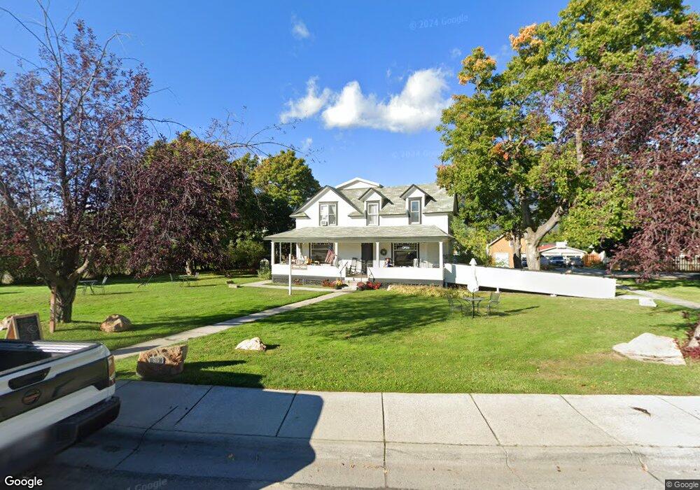
515 Main St Stevensville, MT 59870
Stevensville NeighborhoodEstimated Value: $292,000
3
Beds
3
Baths
2,100
Sq Ft
$139/Sq Ft
Est. Value
About This Home
This home is located at 515 Main St, Stevensville, MT 59870 and is currently priced at $292,000, approximately $139 per square foot. 515 Main St is a home located in Ravalli County with nearby schools including Stevensville Elementary School, Stevensville Junior High School, and Stevensville High School.
Ownership History
Date
Name
Owned For
Owner Type
Purchase Details
Closed on
Sep 25, 2023
Sold by
Chmeleva Svetlana and Parnell Stephen
Bought by
Stala Ventures Llc
Current Estimated Value
Purchase Details
Closed on
Oct 5, 2021
Sold by
Kenneth Bransby
Bought by
Chmeleva Svetlana and Parnell Stephen
Purchase Details
Closed on
Mar 26, 2013
Sold by
Farmers St Bk
Bought by
Bransby Kenneth
Purchase Details
Closed on
Jun 17, 2009
Bought by
Bransby Kenneth
Create a Home Valuation Report for This Property
The Home Valuation Report is an in-depth analysis detailing your home's value as well as a comparison with similar homes in the area
Home Values in the Area
Average Home Value in this Area
Purchase History
| Date | Buyer | Sale Price | Title Company |
|---|---|---|---|
| Stala Ventures Llc | -- | None Listed On Document | |
| Chmeleva Svetlana | -- | New Title Company Name | |
| Bransby Kenneth | $150,000 | Stewart Title | |
| Bransby Kenneth | -- | -- |
Source: Public Records
Mortgage History
| Date | Status | Borrower | Loan Amount |
|---|---|---|---|
| Closed | Bransby Kenneth | $120,000 |
Source: Public Records
Tax History Compared to Growth
Tax History
| Year | Tax Paid | Tax Assessment Tax Assessment Total Assessment is a certain percentage of the fair market value that is determined by local assessors to be the total taxable value of land and additions on the property. | Land | Improvement |
|---|---|---|---|---|
| 2025 | $2,288 | $463,000 | $0 | $0 |
| 2024 | $2,870 | $385,400 | $0 | $0 |
| 2023 | $2,880 | $385,400 | $0 | $0 |
| 2022 | $2,942 | $301,300 | $0 | $0 |
| 2021 | $1,560 | $161,200 | $0 | $0 |
| 2020 | $1,520 | $148,700 | $0 | $0 |
| 2019 | $1,497 | $148,700 | $0 | $0 |
| 2018 | $1,466 | $147,900 | $0 | $0 |
| 2017 | $1,455 | $147,900 | $0 | $0 |
| 2016 | $1,316 | $138,000 | $0 | $0 |
| 2015 | $1,322 | $138,000 | $0 | $0 |
| 2014 | $1,648 | $118,812 | $0 | $0 |
Source: Public Records
Map
Nearby Homes
- 408 Buck St
- 262 Barbara St
- 252 Barbara St
- Lot 5 Bessie Ln
- 308 8th St
- 404 Pine St
- 304 10th St
- 413 5th St
- 325 Valley View St
- 1100 College St
- 306 Valley View St
- 3808 Eastside Hwy
- NHN Mystic River Rd
- 3806 Eastside Hwy
- 623 Park St Unit 3
- 101 Binks Way Unit 19
- 819 E 2nd St
- 211 Middle Burnt Fork Rd
- 3707 Eastside Hwy
- 302 Syringa St
- 515 1/2 Main St
- 517 Main St
- 0 Eastside Hwy Unit 10029252
- 0 Eastside Hwy Unit 20031573
- Lot 18 Eastside Hwy
- Lot 19 Eastside Hwy
- Lot 17 Eastside Hwy
- 0 Eastside Hwy Unit 21813953
- 0 Eastside Hwy Unit 21813568
- - Eastside Hwy
- 4367 Eastside Hwy
- Tract 4a Eastside Hwy
- Tbd Eastside Hwy
- 511 Main St
- 519 Main St
- 505 Main St
- 517 Church St
- 504 Main St
- 513 Church St
- 516 Buck St