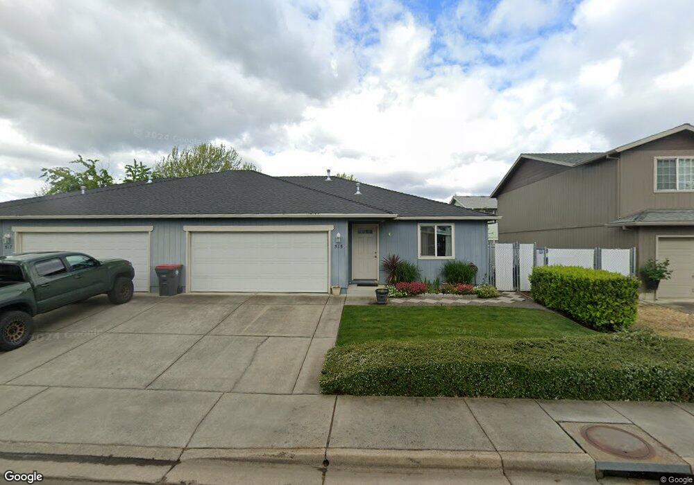
515 Village Dr Central Point, OR 97502
Estimated Value: $461,764 - $539,000
6
Beds
4
Baths
2,166
Sq Ft
$229/Sq Ft
Est. Value
About This Home
This home is located at 515 Village Dr, Central Point, OR 97502 and is currently estimated at $496,441, approximately $229 per square foot. 515 Village Dr is a home located in Jackson County with nearby schools including Central Point Elementary School, Scenic Middle School, and Crater High School.
Ownership History
Date
Name
Owned For
Owner Type
Purchase Details
Closed on
Jan 24, 2025
Sold by
Reichenbach Marsha I
Bought by
Marsha L Reichenbach Trust and Reichenbach
Current Estimated Value
Purchase Details
Closed on
Jan 9, 2002
Sold by
Reichenbach Marsha L
Bought by
Reichenbach Edward T and Reichenbach Marsha L
Home Financials for this Owner
Home Financials are based on the most recent Mortgage that was taken out on this home.
Original Mortgage
$136,000
Interest Rate
7.01%
Purchase Details
Closed on
Aug 1, 2000
Sold by
Redha Corporation
Bought by
Reichenbach Marsha L and Sutherland Family Trust
Home Financials for this Owner
Home Financials are based on the most recent Mortgage that was taken out on this home.
Original Mortgage
$130,000
Interest Rate
8.12%
Create a Home Valuation Report for This Property
The Home Valuation Report is an in-depth analysis detailing your home's value as well as a comparison with similar homes in the area
Home Values in the Area
Average Home Value in this Area
Purchase History
| Date | Buyer | Sale Price | Title Company |
|---|---|---|---|
| Marsha L Reichenbach Trust | -- | None Listed On Document | |
| Reichenbach Edward T | -- | First American Title Ins Co | |
| Reichenbach Marsha L | $185,000 | Amerititle |
Source: Public Records
Mortgage History
| Date | Status | Borrower | Loan Amount |
|---|---|---|---|
| Previous Owner | Reichenbach Edward T | $136,000 | |
| Previous Owner | Reichenbach Marsha L | $130,000 |
Source: Public Records
Tax History Compared to Growth
Tax History
| Year | Tax Paid | Tax Assessment Tax Assessment Total Assessment is a certain percentage of the fair market value that is determined by local assessors to be the total taxable value of land and additions on the property. | Land | Improvement |
|---|---|---|---|---|
| 2025 | $4,403 | $264,840 | $76,230 | $188,610 |
| 2024 | $4,403 | $257,130 | $74,010 | $183,120 |
| 2023 | $4,262 | $249,650 | $71,860 | $177,790 |
| 2022 | $4,162 | $249,650 | $71,860 | $177,790 |
| 2021 | $4,043 | $242,380 | $69,770 | $172,610 |
| 2020 | $3,925 | $235,330 | $67,740 | $167,590 |
| 2019 | $3,829 | $221,830 | $63,850 | $157,980 |
| 2018 | $3,712 | $215,370 | $61,990 | $153,380 |
| 2017 | $3,619 | $215,370 | $61,990 | $153,380 |
| 2016 | $3,513 | $203,010 | $58,420 | $144,590 |
| 2015 | $3,366 | $203,010 | $58,420 | $144,590 |
| 2014 | $3,280 | $191,360 | $55,070 | $136,290 |
Source: Public Records
Map
Nearby Homes
- 928 Brandi Way
- 851 Juanita Way
- 571 Briarwood Dr
- 921 Pittview Ave
- 1017 Fairfield Ave
- 1025 Fairfield Ave
- 301 Freeman Rd Unit 100
- 301 Freeman Rd Unit 23
- 230 Peninger Rd
- 555 Freeman Rd Unit 128
- 555 Freeman Rd Unit 254
- 555 Freeman Rd Unit 105
- 555 Freeman Rd Unit 204
- 555 Freeman Rd Unit 209
- 3364 Bursell Rd
- 460 Federal Way
- 1600 E Pine St
- 3358 Bursell Rd
- 959 Westrop Dr
- 340 Freeman Rd
- 514 Mountain View Dr
- 512 Mountain View Dr
- 527 Village Dr
- 527 Village Dr Unit 529
- 527 Village 529
- 507 Village Dr
- 522 Mountain View Dr
- 528 Village Dr Unit C12
- 526 Village Dr Unit C11
- 502 Mountain View Dr
- 538 Village Dr Unit 16
- 536 Village Dr Unit D15
- 500 Mountain View Dr
- 524 Village Dr Unit C10
- 516 Village Dr Unit B7
- 518 Village Dr Unit B8
- 534 Village Dr Unit D14
- 545 Village Dr
- 522 Village Dr Unit 9
- 52729 Village Dr