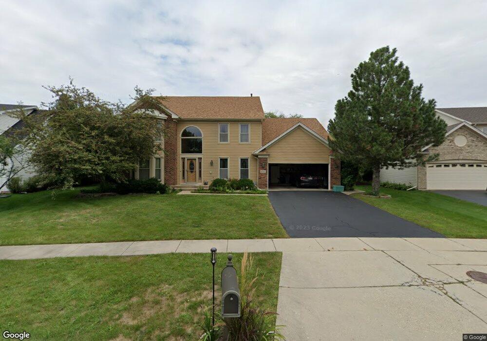
5150 Landers Dr Hoffman Estates, IL 60192
West Hoffman Estates NeighborhoodEstimated Value: $593,938 - $698,000
3
Beds
3
Baths
2,911
Sq Ft
$222/Sq Ft
Est. Value
About This Home
This home is located at 5150 Landers Dr, Hoffman Estates, IL 60192 and is currently estimated at $646,485, approximately $222 per square foot. 5150 Landers Dr is a home located in Cook County with nearby schools including Barbara B. Rose Elementary School, Barrington Mdle School- Prairie Cmps, and Barrington High School.
Ownership History
Date
Name
Owned For
Owner Type
Purchase Details
Closed on
Feb 20, 2006
Sold by
Gaynor Leslie A
Bought by
Gaynor Leslie A and Leslie A Gaynor Declaration Of Trust
Current Estimated Value
Purchase Details
Closed on
Aug 16, 2002
Sold by
Perham David M and Perham Charlene K
Bought by
Gaynor Leslie A
Purchase Details
Closed on
Oct 2, 1997
Sold by
Perham David M and Perham Charlene K
Bought by
Perham David M and Perham Livin K L
Create a Home Valuation Report for This Property
The Home Valuation Report is an in-depth analysis detailing your home's value as well as a comparison with similar homes in the area
Home Values in the Area
Average Home Value in this Area
Purchase History
We collect this data history from publicly available records. To have your information removed, we recommend requesting removal directly through your county’s website.
| Date | Buyer | Sale Price | Title Company |
|---|---|---|---|
| Gaynor Leslie A | -- | None Available | |
| Gaynor Leslie A | $415,000 | -- | |
| Perham David M | -- | -- |
Source: Public Records
Tax History
| Year | Tax Paid | Tax Assessment Tax Assessment Total Assessment is a certain percentage of the fair market value that is determined by local assessors to be the total taxable value of land and additions on the property. | Land | Improvement |
|---|---|---|---|---|
| 2025 | $10,123 | $58,001 | $10,490 | $47,511 |
| 2024 | $10,123 | $39,832 | $9,091 | $30,741 |
| 2023 | $10,905 | $47,000 | $9,091 | $37,909 |
| 2022 | $10,905 | $47,000 | $9,091 | $37,909 |
| 2021 | $8,705 | $31,809 | $8,391 | $23,418 |
| 2020 | $8,483 | $31,809 | $8,391 | $23,418 |
| 2019 | $8,311 | $35,344 | $8,391 | $26,953 |
| 2018 | $8,043 | $32,522 | $7,342 | $25,180 |
| 2017 | $7,876 | $32,522 | $7,342 | $25,180 |
| 2016 | $7,593 | $32,522 | $7,342 | $25,180 |
| 2015 | $8,774 | $35,102 | $6,643 | $28,459 |
| 2014 | $8,643 | $35,102 | $6,643 | $28,459 |
| 2013 | $8,289 | $35,102 | $6,643 | $28,459 |
Source: Public Records
Map
Nearby Homes
- 1820 Nicholson Dr
- 1940 Morningview Dr
- 5355 Galloway Dr
- 5285 Shotkoski Dr
- 5180 Shotkoski Dr
- 5423 Swan Cir
- 2050 Colchester Ave
- 2075 Ivy Ridge Dr Unit 2075
- 1249 Mallard Ln
- 1235 Mallard Ln
- 5670 Brentwood Dr Unit 5
- 5650 Brentwood Dr
- 1715 White Oak Ln
- 5791 Providence Dr
- 2221 Edgartown Ln
- 2124 Amelia Ln
- 1612 Bur Oak Dr
- 6044 Canterbury Ln Unit 93
- 1479 Mackenzie Ln
- 6051 Canterbury Ln
- 1810 Nicholson Dr
- 5155 Landers Dr
- 1800 Nicholson Dr
- 1840 Nicholson Dr
- 5201 Elliott Dr
- 1825 Nicholson Dr
- 5165 Landers Dr
- 1835 Nicholson Dr
- 1815 Nicholson Dr
- 5205 Elliott Dr Unit 2
- 5140 Landers Dr
- 1845 Nicholson Dr
- 1790 Nicholson Dr
- 1805 Nicholson Dr
- 1850 Nicholson Dr
- 1855 Nicholson Dr
- 5209 Elliott Dr
- 5160 Landers Dr
- 1795 Nicholson Dr
- 1780 Nicholson Dr Unit 3
Your Personal Tour Guide
Ask me questions while you tour the home.