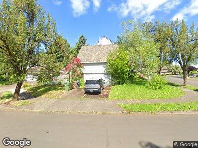
5153 SW Malsam Ct Tualatin, OR 97062
Tualatin East NeighborhoodEstimated Value: $739,000 - $875,000
4
Beds
3
Baths
2,982
Sq Ft
$272/Sq Ft
Est. Value
About This Home
This home is located at 5153 SW Malsam Ct, Tualatin, OR 97062 and is currently estimated at $812,027, approximately $272 per square foot. 5153 SW Malsam Ct is a home located in Clackamas County with nearby schools including Bridgeport Elementary School, Hazelbrook Middle School, and Tualatin High School.
Ownership History
Date
Name
Owned For
Owner Type
Purchase Details
Closed on
Oct 30, 2000
Sold by
Cleveland Michael L and Cleveland Mary B
Bought by
Lamb Mary K
Current Estimated Value
Home Financials for this Owner
Home Financials are based on the most recent Mortgage that was taken out on this home.
Original Mortgage
$240,000
Interest Rate
7.66%
Purchase Details
Closed on
Dec 22, 1999
Sold by
Carlson Robert William and Carlson Deborah A
Bought by
Cleveland Michael L and Cleveland Mary B
Home Financials for this Owner
Home Financials are based on the most recent Mortgage that was taken out on this home.
Original Mortgage
$230,000
Interest Rate
6.75%
Create a Home Valuation Report for This Property
The Home Valuation Report is an in-depth analysis detailing your home's value as well as a comparison with similar homes in the area
Home Values in the Area
Average Home Value in this Area
Purchase History
| Date | Buyer | Sale Price | Title Company |
|---|---|---|---|
| Lamb Mary K | $300,000 | Fidelity National Title Co | |
| Cleveland Michael L | $250,000 | Chicago Title |
Source: Public Records
Mortgage History
| Date | Status | Borrower | Loan Amount |
|---|---|---|---|
| Open | Lamb Mary K | $199,113 | |
| Closed | Lamb Mary K | $240,000 | |
| Previous Owner | Cleveland Michael L | $230,000 |
Source: Public Records
Tax History Compared to Growth
Tax History
| Year | Tax Paid | Tax Assessment Tax Assessment Total Assessment is a certain percentage of the fair market value that is determined by local assessors to be the total taxable value of land and additions on the property. | Land | Improvement |
|---|---|---|---|---|
| 2023 | $8,395 | $453,658 | $0 | $0 |
| 2022 | $7,827 | $440,445 | $0 | $0 |
| 2021 | $7,546 | $427,617 | $0 | $0 |
| 2020 | $7,275 | $415,163 | $0 | $0 |
| 2019 | $7,094 | $403,071 | $0 | $0 |
| 2018 | $6,808 | $391,331 | $0 | $0 |
| 2017 | $6,271 | $379,933 | $0 | $0 |
| 2016 | $5,960 | $368,867 | $0 | $0 |
| 2015 | $5,743 | $358,123 | $0 | $0 |
| 2014 | $5,416 | $347,692 | $0 | $0 |
Source: Public Records
Map
Nearby Homes
- 20053 SW 54th Terrace
- 5245 SW Greenwood Cir
- 5085 SW Greenwood Cir
- 19642 SW 56th Ct
- 5225 SW Joshua St
- 19580 SW 56th Ct
- 19580 SW 48th Ave
- 5795 SW Sequoia Dr
- 5393 SW Wichita St
- 20160 SW 58th Terrace
- 5785 SW Calusa Loop
- 20001 SW 61st Terrace
- 19368 Riverwood Ln
- 4679 Dogwood Dr
- 19455 SW Tualasaum Dr
- 20036 SW 64th Terrace
- 19331 SW Lorna Ln
- 5455 Childs Rd
- 5527 SW Childs Rd
- 5670 Childs Rd
- 5153 SW Malsam Ct
- 5153 SW Malsam Ct 3 15 Bac
- 5155 SW Malsam Ct
- 5145 SW Greenwood Cir
- 5130 SW Greenwood Cir
- 5157 SW Malsam Ct
- 5135 SW Greenwood Cir
- 5150 SW Greenwood Cir
- 5170 SW Malsam Ct
- 5110 SW Greenwood Cir
- 5160 SW Malsam Ct
- 5166 SW Malsam Ct
- 5162 SW Malsam Ct
- 5125 SW Greenwood Cir
- 5175 SW Greenwood Cir
- 5361 SW Borland Rd
- 5252 SW Greenwood Place
- 5100 SW Greenwood Cir
- 5180 SW Greenwood Cir
- 5115 SW Greenwood Cir