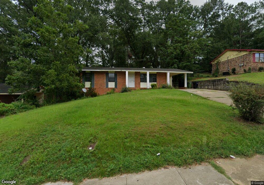
516 Farr Rd Columbus, GA 31907
Eastern Columbus NeighborhoodEstimated Value: $116,000 - $168,000
3
Beds
3
Baths
1,100
Sq Ft
$124/Sq Ft
Est. Value
About This Home
This home is located at 516 Farr Rd, Columbus, GA 31907 and is currently estimated at $136,535, approximately $124 per square foot. 516 Farr Rd is a home located in Muscogee County with nearby schools including St. Mary's Road Magnet Academy, Rothschild Leadership Academy, and Spencer High School.
Ownership History
Date
Name
Owned For
Owner Type
Purchase Details
Closed on
Jun 17, 2011
Sold by
Coast 2 Coast Lending Grp
Bought by
Gardner Brinson B
Current Estimated Value
Purchase Details
Closed on
Jan 27, 2011
Sold by
Fannie Mae
Bought by
Coast 2 Coast Lending Group Llc Series C
Purchase Details
Closed on
Oct 5, 2010
Sold by
Wells Fargo Bank Na
Bought by
Federal National Mortgage Association
Purchase Details
Closed on
Sep 17, 2008
Sold by
Peak Fred D
Bought by
Price Neolina L
Purchase Details
Closed on
Jun 13, 2006
Sold by
Broad Holdings Llc
Bought by
Peak Fred D
Create a Home Valuation Report for This Property
The Home Valuation Report is an in-depth analysis detailing your home's value as well as a comparison with similar homes in the area
Home Values in the Area
Average Home Value in this Area
Purchase History
| Date | Buyer | Sale Price | Title Company |
|---|---|---|---|
| Gardner Brinson B | $17,000 | -- | |
| Coast 2 Coast Lending Group Llc Series C | $9,500 | None Available | |
| Federal National Mortgage Association | -- | None Available | |
| Wells Fargo Bank Na | $53,479 | None Available | |
| Price Neolina L | -- | None Available | |
| Peak Fred D | -- | None Available |
Source: Public Records
Tax History Compared to Growth
Tax History
| Year | Tax Paid | Tax Assessment Tax Assessment Total Assessment is a certain percentage of the fair market value that is determined by local assessors to be the total taxable value of land and additions on the property. | Land | Improvement |
|---|---|---|---|---|
| 2025 | $5,184 | $38,788 | $9,592 | $29,196 |
| 2024 | $3,666 | $38,788 | $9,592 | $29,196 |
| 2023 | $1,528 | $38,788 | $9,592 | $29,196 |
| 2022 | $1,060 | $25,956 | $9,592 | $16,364 |
| 2021 | $1,048 | $25,604 | $9,592 | $16,012 |
| 2020 | $1,046 | $25,604 | $9,592 | $16,012 |
| 2019 | $1,049 | $25,604 | $9,592 | $16,012 |
| 2018 | $1,049 | $25,604 | $9,592 | $16,012 |
| 2017 | $1,196 | $25,604 | $9,592 | $16,012 |
| 2016 | $736 | $17,832 | $3,078 | $14,754 |
| 2015 | $295 | $17,832 | $3,078 | $14,754 |
| 2014 | $295 | $17,832 | $3,078 | $14,754 |
| 2013 | -- | $17,832 | $3,078 | $14,754 |
Source: Public Records
Map
Nearby Homes
- 4408 Ridgefield Dr
- 4422 Debolt Ct
- 4437 St Marys Rd
- 4422 Pate Dr
- 4516 Sims St
- 4534 Sentry St
- 4718 Velpoe Dr
- 4581 Dawn Ct
- 1234 Hanover Ave
- 811 Pheasant Loop
- 130 Sycamore Ct
- 229 N Oakley Dr
- 3510 Califon Ct
- 59 Apollo Dr
- 4917 Brightstar Ln
- 4930 Capricorn Ct
- 4510 Tracy St
- 4201 Valley Crest Dr
- 4145 Braddock Dr
- 1025 Belmar St