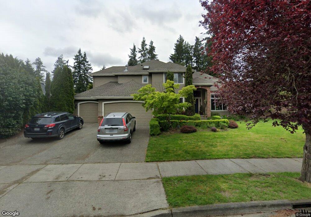
519 210th St SE Bothell, WA 98021
Queensborough-Brentwood NeighborhoodEstimated Value: $1,309,542 - $1,438,000
3
Beds
3
Baths
2,931
Sq Ft
$473/Sq Ft
Est. Value
About This Home
This home is located at 519 210th St SE, Bothell, WA 98021 and is currently estimated at $1,387,636, approximately $473 per square foot. 519 210th St SE is a home located in Snohomish County with nearby schools including Crystal Springs Elementary School, Canyon Park Junior High School, and Bothell High School.
Ownership History
Date
Name
Owned For
Owner Type
Purchase Details
Closed on
Oct 31, 2002
Sold by
Brooks Homes Inc
Bought by
Sim Thada and Ky Savadee
Current Estimated Value
Home Financials for this Owner
Home Financials are based on the most recent Mortgage that was taken out on this home.
Original Mortgage
$295,950
Outstanding Balance
$123,687
Interest Rate
5.99%
Mortgage Type
Stand Alone First
Estimated Equity
$1,263,949
Create a Home Valuation Report for This Property
The Home Valuation Report is an in-depth analysis detailing your home's value as well as a comparison with similar homes in the area
Home Values in the Area
Average Home Value in this Area
Purchase History
| Date | Buyer | Sale Price | Title Company |
|---|---|---|---|
| Sim Thada | $425,955 | Chicago Title Insurance Co |
Source: Public Records
Mortgage History
| Date | Status | Borrower | Loan Amount |
|---|---|---|---|
| Open | Sim Thada | $295,950 |
Source: Public Records
Tax History
| Year | Tax Paid | Tax Assessment Tax Assessment Total Assessment is a certain percentage of the fair market value that is determined by local assessors to be the total taxable value of land and additions on the property. | Land | Improvement |
|---|---|---|---|---|
| 2025 | $8,769 | $1,113,300 | $575,000 | $538,300 |
| 2024 | $8,769 | $1,049,800 | $555,000 | $494,800 |
| 2023 | $9,188 | $1,202,700 | $640,000 | $562,700 |
| 2022 | $8,086 | $853,300 | $375,000 | $478,300 |
| 2020 | $7,299 | $714,000 | $303,000 | $411,000 |
| 2019 | $6,720 | $681,800 | $250,000 | $431,800 |
| 2018 | $6,192 | $605,300 | $220,000 | $385,300 |
| 2017 | $5,517 | $546,100 | $180,000 | $366,100 |
| 2016 | $5,090 | $520,700 | $170,000 | $350,700 |
| 2015 | $4,790 | $463,600 | $157,000 | $306,600 |
| 2013 | $4,284 | $364,500 | $126,000 | $238,500 |
Source: Public Records
Map
Nearby Homes
- 738 211th Place SE
- 722 211th Place SE
- 721 211th Place SE
- 729 211th Place SE
- 809 211th Place SE
- 803 211th Place SE
- 300 208th St SE
- 309 207th Place SE
- 20911 W Richmond Rd
- 21414 2nd Ave SE
- 20511 Greening Rd
- 618 203rd St SE
- 429 203rd Place SE
- 21120 Meridian Place W
- 33 213th Place SW
- 21723 3rd Ave SE
- 820 Grimes Rd
- 20912 2nd Ave W
- 20902 2nd Ave W
- 20029 7th Ave SE
- 511 210th St SE
- 503 210th St SE
- 20925 Royal Anne Rd
- 427 210th St SE
- 21100 Royal Anne Rd
- 430 210th St SE
- 20923 4th Ave SE
- 415 210th St SE
- 20902 Royal Anne Rd
- 422 210th St SE
- 513 211th Place SE
- 406 210th St SE
- 20909 Royal Anne Rd
- 507 211th Place SE
- 20910 Royal Anne Rd
- 427 211th Place SE
- 21105 Royal Anne Rd
- 414 210th St SE
- 0 Lot C Royal Anne Rd
- 0 D Royal Anne Rd
Your Personal Tour Guide
Ask me questions while you tour the home.