T
Seller's Agent in 2026
The Riel Estate Team
Keller Williams Pinnacle Central
(508) 213-1285
2 in this area
525 Total Sales
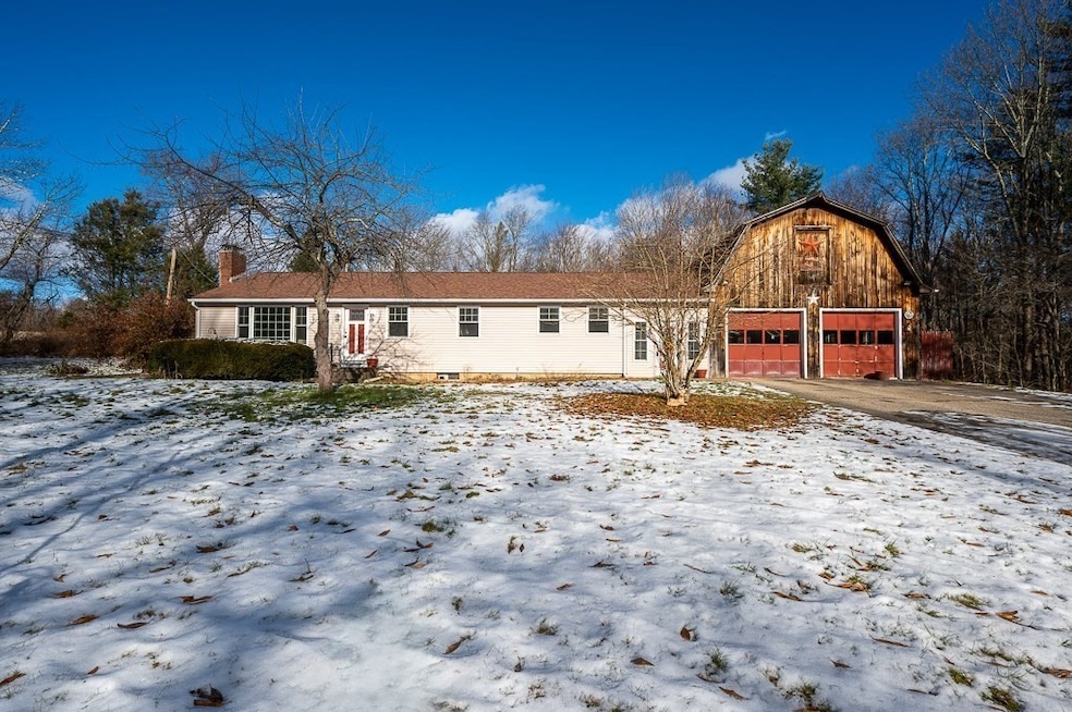


This charming 3-bed ranch offers comfortable one-level living. Enter in via a spacious tiled breezeway connecting the home to an oversized, heated 2-car garage. In the main living side you will find a gorgeous kitchen featuring cathedral ceilings, tile floors, ample cabinetry, and full appliances. The spacious living room offers beautiful wood floors, natural light via large picture window & features a cozy pellet stove. Open concept dining room off the kitchen makes for easy entertaining & features sliding doors to the back deck. The primary suite features a master bath with double vanity & walk in shower. Highlights include: first-floor laundry; central air; new solar panels; new electrical work; new smoke and CO detectors; new septic pump float control, and alarm control; new carpets installed in 2 of the bedrooms; cathedral kitchen ceilings and an unfinished bonus room above the garage. Enjoy your spacious, private backyard. Located on a rural road not far from Rt 9 and the Pike.
Last Agent to Sell the Property
Keller Williams Pinnacle Central Listed on: 12/12/2025

Last Buyer's Agent
Brenda Kelsey
Port Real Estate Services
| Date | Type | Sale Price | Title Company |
|---|---|---|---|
| Fiduciary Deed | $405,000 | -- | |
| Quit Claim Deed | $195,000 | -- |
| Date | Status | Loan Amount | Loan Type |
|---|---|---|---|
| Open | $411,657 | Purchase Money Mortgage | |
| Previous Owner | $156,000 | New Conventional |
| Date | Event | Price | List to Sale | Price per Sq Ft |
|---|---|---|---|---|
| 02/24/2026 02/24/26 | Sold | $405,000 | +1.3% | $312 / Sq Ft |
| 12/16/2025 12/16/25 | Pending | -- | -- | -- |
| 12/12/2025 12/12/25 | For Sale | $399,900 | -- | $308 / Sq Ft |
| Year | Tax Paid | Tax Assessment Tax Assessment Total Assessment is a certain percentage of the fair market value that is determined by local assessors to be the total taxable value of land and additions on the property. | Land | Improvement |
|---|---|---|---|---|
| 2025 | $4,077 | $275,300 | $58,200 | $217,100 |
| 2024 | $4,149 | $275,300 | $58,200 | $217,100 |
| 2023 | $4,065 | $257,300 | $58,200 | $199,100 |
| 2022 | $3,366 | $216,300 | $44,500 | $171,800 |
| 2021 | $5,382 | $206,700 | $42,100 | $164,600 |
| 2020 | $888 | $194,800 | $42,100 | $152,700 |
| 2019 | $3,356 | $184,900 | $42,100 | $142,800 |
| 2018 | $893 | $175,700 | $42,100 | $133,600 |
| 2017 | $3,062 | $165,000 | $43,700 | $121,300 |
| 2016 | $2,992 | $150,800 | $41,700 | $109,100 |
| 2015 | $2,786 | $148,600 | $41,700 | $106,900 |
| 2014 | $2,894 | $151,500 | $41,700 | $109,800 |
T
Seller's Agent in 2026
The Riel Estate Team
Keller Williams Pinnacle Central
(508) 213-1285
2 in this area
525 Total Sales
Seller Co-Listing Agent in 2026
Nathan Riel
Keller Williams Pinnacle Central
(508) 754-3020
1 in this area
184 Total Sales
B
Buyer's Agent in 2026
Brenda Kelsey
Port Real Estate Services
Source: MLS Property Information Network (MLS PIN)
MLS Number: 73461852
APN: WARR-000025-000000-000020
Disclaimer: Certain information contained herein is derived from information provided by parties other than Homes.com. All information provided is deemed reliable, but is not guaranteed to be accurate and should be independently verified.
![]() The property listing data and information, or the Images, set forth herein were provided to MLS Property Information Network, Inc. from third party sources, including sellers, lessors and public records, and were compiled by MLS Property Information Network, Inc. The property listing data and information, and the Images, are for the personal, non-commercial use of consumers having a good faith interest in purchasing or leasing listed properties of the type displayed to them and may not be used for any purpose other than to identify prospective properties which such consumers may have a good faith interest in purchasing or leasing. MLS Property Information Network, Inc. and its subscribers disclaim any and all representations and warranties as to the accuracy of the property listing data and information, or as to the accuracy of any of the Images, set forth herein.
The property listing data and information, or the Images, set forth herein were provided to MLS Property Information Network, Inc. from third party sources, including sellers, lessors and public records, and were compiled by MLS Property Information Network, Inc. The property listing data and information, and the Images, are for the personal, non-commercial use of consumers having a good faith interest in purchasing or leasing listed properties of the type displayed to them and may not be used for any purpose other than to identify prospective properties which such consumers may have a good faith interest in purchasing or leasing. MLS Property Information Network, Inc. and its subscribers disclaim any and all representations and warranties as to the accuracy of the property listing data and information, or as to the accuracy of any of the Images, set forth herein.
Ask me questions while you tour the home.