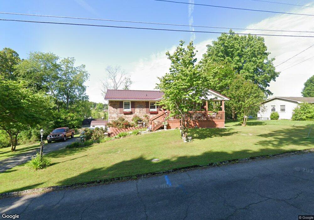
519 Springfield Dr Bristol, TN 37620
Estimated Value: $178,117 - $248,000
Studio
2
Baths
1,000
Sq Ft
$227/Sq Ft
Est. Value
About This Home
This home is located at 519 Springfield Dr, Bristol, TN 37620 and is currently estimated at $227,279, approximately $227 per square foot. 519 Springfield Dr is a home located in Sullivan County with nearby schools including Bluff City Elementary School, Sullivan East Middle School, and Sullivan East High School.
Ownership History
Date
Name
Owned For
Owner Type
Purchase Details
Closed on
Jan 10, 1990
Current Estimated Value
Create a Home Valuation Report for This Property
The Home Valuation Report is an in-depth analysis detailing your home's value as well as a comparison with similar homes in the area
Purchase History
| Date | Buyer | Sale Price | Title Company |
|---|---|---|---|
| -- | $49,500 | -- |
Source: Public Records
Tax History
| Year | Tax Paid | Tax Assessment Tax Assessment Total Assessment is a certain percentage of the fair market value that is determined by local assessors to be the total taxable value of land and additions on the property. | Land | Improvement |
|---|---|---|---|---|
| 2025 | $1,068 | $66,225 | $5,025 | $61,200 |
| 2024 | $700 | $28,025 | $3,525 | $24,500 |
| 2023 | $674 | $28,025 | $3,525 | $24,500 |
| 2022 | $674 | $28,025 | $3,525 | $24,500 |
| 2021 | $674 | $28,025 | $3,525 | $24,500 |
| 2020 | $677 | $28,025 | $3,525 | $24,500 |
| 2019 | $677 | $26,350 | $3,525 | $22,825 |
| 2018 | $643 | $25,225 | $3,525 | $21,700 |
| 2017 | $643 | $25,225 | $3,525 | $21,700 |
| 2016 | $617 | $23,950 | $3,525 | $20,425 |
| 2014 | $552 | $23,949 | $0 | $0 |
Source: Public Records
Map
Nearby Homes
- 436 Springfield Dr
- 361 Springfield Dr
- 257 Broyles Rd
- 2030 Vance Tank Rd Unit 1
- TBD Sweet Knobs Trail
- 228 Country Meadows Cir
- 229 Country Meadow Cir
- 229 Country Meadows Cir
- 549 Pleasant Grove Rd
- 413 Paddle Creek Rd
- Tbd Paddle Creek Rd
- 1026 Deer Harbour Rd
- Tbd Sportsway Dr
- 3257 Avoca Rd
- 3253 Avoca Rd
- 4118 Weaver Pike
- 4045 Weaver Pike
- 18 Ross St
- 220 Peters Rd
- 1320 Silver Grove Rd
- 525 Springfield Dr
- 509 Springfield Dr
- 338 Broyles Ln
- 512 Springfield Dr
- 302 Mayfield Dr
- 535 Springfield Dr
- 505 Springfield Dr
- 368 Broyles Ln
- 376 Broyles Ln
- 496 Springfield Dr
- 310 Mayfield Dr
- 499 Springfield Dr
- 543 Springfield Dr
- 372 Broyles Ln
- 301 Mayfield Dr
- 318 Mayfield Dr
- 488 Springfield Dr
- 493 Springfield Dr
- 315 Broyles Ln
- 309 Mayfield Dr
Your Personal Tour Guide
Ask me questions while you tour the home.