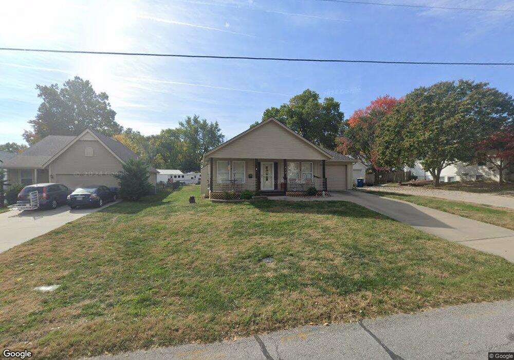
519 Thornton St Liberty, MO 64068
Estimated Value: $261,000 - $284,000
2
Beds
2
Baths
1,134
Sq Ft
$240/Sq Ft
Est. Value
About This Home
This home is located at 519 Thornton St, Liberty, MO 64068 and is currently estimated at $272,662, approximately $240 per square foot. 519 Thornton St is a home located in Clay County with nearby schools including Ridgeview Elementary School, Heritage Middle School, and Liberty North High School.
Ownership History
Date
Name
Owned For
Owner Type
Purchase Details
Closed on
Sep 24, 2013
Sold by
Abbiatti Dorothy M and Abbiatti David K
Bought by
Boydston Dale and Boydston Barbara
Current Estimated Value
Purchase Details
Closed on
Jul 19, 2010
Sold by
Abbiatti Dorothy M
Bought by
Abbiatti Dorothy M and Abbiatti David K
Purchase Details
Closed on
Oct 23, 2008
Sold by
Phoenix Construction Inc
Bought by
Abbiatti Robert G and Abbiatti Dorothy M
Create a Home Valuation Report for This Property
The Home Valuation Report is an in-depth analysis detailing your home's value as well as a comparison with similar homes in the area
Home Values in the Area
Average Home Value in this Area
Purchase History
| Date | Buyer | Sale Price | Title Company |
|---|---|---|---|
| Boydston Dale | -- | Thomson Affinity Title Llc | |
| Abbiatti Dorothy M | -- | None Available | |
| Abbiatti Robert G | -- | None Available |
Source: Public Records
Tax History Compared to Growth
Tax History
| Year | Tax Paid | Tax Assessment Tax Assessment Total Assessment is a certain percentage of the fair market value that is determined by local assessors to be the total taxable value of land and additions on the property. | Land | Improvement |
|---|---|---|---|---|
| 2025 | $2,730 | $39,440 | -- | -- |
| 2024 | $2,730 | $35,490 | -- | -- |
| 2023 | $2,776 | $35,490 | $0 | $0 |
| 2022 | $2,518 | $31,790 | $0 | $0 |
| 2021 | $2,499 | $31,787 | $5,320 | $26,467 |
| 2020 | $2,253 | $26,920 | $0 | $0 |
| 2019 | $2,253 | $26,920 | $0 | $0 |
| 2018 | $2,057 | $24,130 | $0 | $0 |
| 2017 | $2,038 | $24,120 | $2,560 | $21,560 |
| 2016 | $2,038 | $24,120 | $2,560 | $21,560 |
| 2015 | $2,038 | $24,120 | $2,560 | $21,560 |
| 2014 | $1,965 | $23,080 | $2,560 | $20,520 |
Source: Public Records
Map
Nearby Homes
- 605 Reed St
- 116 Dorsey St
- 15 Valley Rd
- 324 Harrison St
- 506 W Mississippi St
- 248 Range Line Rd
- 21 Cedar St
- 1025 Orchard Ave
- 412 N Fairview Ave
- 194 Camelot Dr
- 206 Groom St
- 17 Main Ct
- 307 N Gallatin St
- 819 S Main St
- 0 N Water St
- 134 S Lincoln St
- 125 N Leonard St
- 215 Grant St
- 317 Camelot Dr
- 815 Kings Ridge
- 517 Thornton St
- 204 Moss Ave
- 511 Thornton St
- 205 S Fairview Ave
- 201 S Fairview Ave
- 211 S Fairview Ave
- 208 Moss Ave
- 216 Moss Ave
- 520 Thorton St
- 303 S Fairview Ave
- 520 Thornton St
- 510 Thornton St
- 508 Thornton St
- 224 Moss Ave
- 600 Dixie St
- 506 Thornton St
- 601 Thornton St
- 307 S Fairview Ave
- 131 S Fairview Ave
- 527 W Liberty Dr