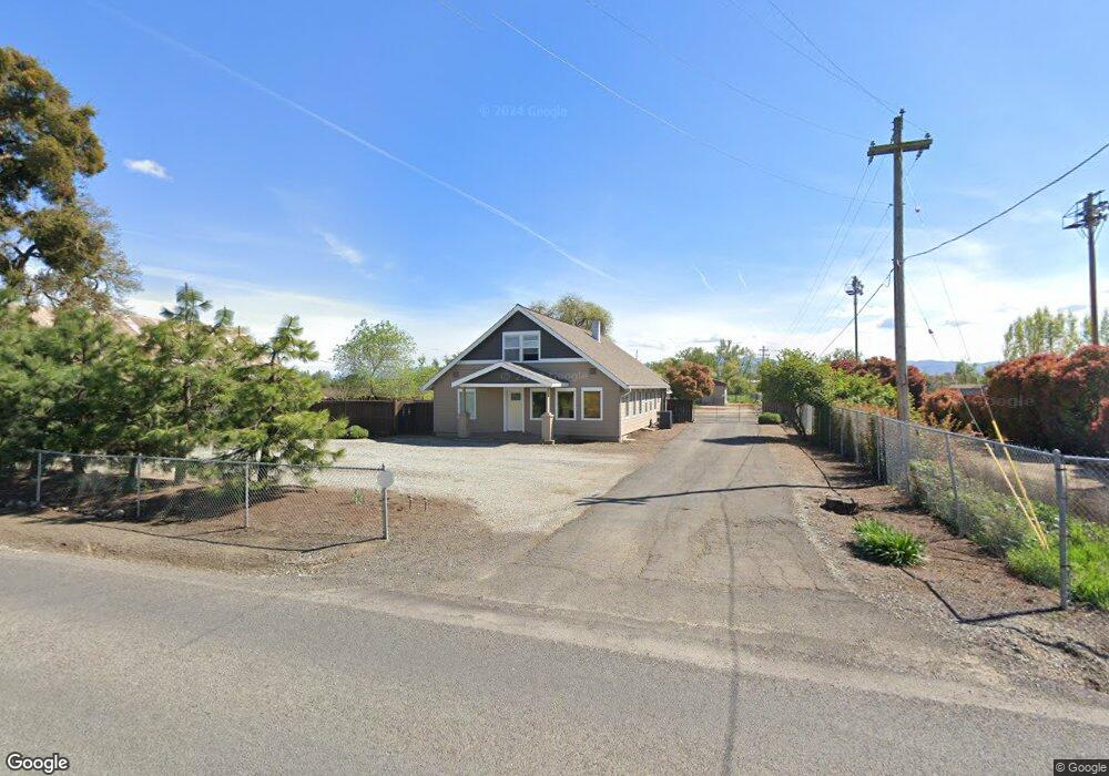
5196 Upton Rd Central Point, OR 97502
Estimated Value: $448,382 - $569,000
4
Beds
3
Baths
2,376
Sq Ft
$206/Sq Ft
Est. Value
About This Home
This home is located at 5196 Upton Rd, Central Point, OR 97502 and is currently estimated at $489,461, approximately $206 per square foot. 5196 Upton Rd is a home located in Jackson County with nearby schools including Jewett Elementary School, Scenic Middle School, and Crater High School.
Ownership History
Date
Name
Owned For
Owner Type
Purchase Details
Closed on
Nov 25, 2008
Sold by
Mortgage Electronic Registration Systems
Bought by
Keeble Linda
Current Estimated Value
Purchase Details
Closed on
May 22, 2008
Sold by
Brown Henrietta C
Bought by
Mortgage Electronic Registration Systems and Aurora Loan Services Llc
Purchase Details
Closed on
Nov 26, 2003
Sold by
Severson Clyde A and Severson Susan C
Bought by
Brown Henrietta C
Home Financials for this Owner
Home Financials are based on the most recent Mortgage that was taken out on this home.
Original Mortgage
$144,000
Interest Rate
8.5%
Mortgage Type
Purchase Money Mortgage
Purchase Details
Closed on
Feb 21, 2002
Sold by
Meuser George E and Meuser Judith G
Bought by
Severson Clyde A and Severson Susan C
Create a Home Valuation Report for This Property
The Home Valuation Report is an in-depth analysis detailing your home's value as well as a comparison with similar homes in the area
Purchase History
| Date | Buyer | Sale Price | Title Company |
|---|---|---|---|
| Keeble Linda | $250,000 | None Available | |
| Mortgage Electronic Registration Systems | $266,340 | Ticor Title | |
| Brown Henrietta C | $175,000 | First American Title Ins Co | |
| Severson Clyde A | $105,000 | -- |
Source: Public Records
Mortgage History
| Date | Status | Borrower | Loan Amount |
|---|---|---|---|
| Previous Owner | Brown Henrietta C | $144,000 |
Source: Public Records
Tax History
| Year | Tax Paid | Tax Assessment Tax Assessment Total Assessment is a certain percentage of the fair market value that is determined by local assessors to be the total taxable value of land and additions on the property. | Land | Improvement |
|---|---|---|---|---|
| 2026 | $2,778 | $228,550 | $136,630 | $91,920 |
| 2025 | $2,715 | $226,440 | $158,480 | $67,960 |
| 2024 | $2,715 | $219,850 | $153,860 | $65,990 |
| 2023 | $2,564 | $196,640 | $139,430 | $57,210 |
| 2022 | $2,642 | $219,510 | $92,720 | $126,790 |
| 2021 | $2,567 | $213,120 | $90,020 | $123,100 |
| 2020 | $2,492 | $206,920 | $87,390 | $119,530 |
| 2019 | $2,435 | $195,050 | $82,360 | $112,690 |
| 2018 | $2,359 | $188,290 | $82,900 | $105,390 |
| 2017 | $2,284 | $188,290 | $82,900 | $105,390 |
| 2016 | $2,228 | $178,510 | $75,370 | $103,140 |
| 2015 | $2,106 | $169,750 | $73,170 | $96,580 |
| 2014 | $1,960 | $160,480 | $67,090 | $93,390 |
Source: Public Records
Map
Nearby Homes
- 0 Peninger Rd
- 1653 Kentucky Ct
- 1153 Annalise St
- 1617 Tennessee Ln
- 4722 Gebhard Rd
- 1121 Annalise St
- 1113 Annalise St
- 833 Hazel St
- 4065 Crestwood Cir
- 1109 Annalise St
- 106 Victoria Way
- 549 Wilson Rd
- 2335 New Haven Dr
- 331 N 8th St
- 2311 Lara Ln
- 731 Maple St
- 1855 Nancy Ave
- 2460 Jeremy St
- 55 Crater Ln
- 140 N 8th St
- 5220 Upton Rd
- 5113 Upton Rd
- 5230 Upton Rd
- 5294 Upton Rd
- 5294 Upton Rd Rd
- 5368 Upton Rd
- 5402 Upton Rd
- 5418 Upton Rd
- 5418 Upton Rd
- 0 Upton Rd Unit 220181265
- 0 Upton Rd Unit 220143792
- 0 Upton Rd Unit 103010652
- 0 Upton Rd Unit 3010652
- 5053 Upton Rd
- 5432 Upton Rd
- 5461 Upton Rd
- 5454 Upton Rd
- 5041 Upton Rd
- 5476 Upton Rd
- 5485 Upton Rd
Your Personal Tour Guide
Ask me questions while you tour the home.