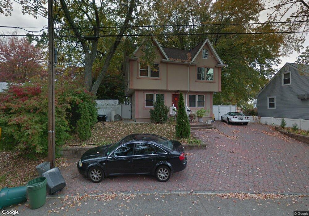
52 Lakeside Ave Haskell, NJ 07420
Estimated Value: $456,000 - $500,000
Studio
--
Bath
1,568
Sq Ft
$307/Sq Ft
Est. Value
About This Home
This home is located at 52 Lakeside Ave, Haskell, NJ 07420 and is currently estimated at $480,970, approximately $306 per square foot. 52 Lakeside Ave is a home located in Passaic County with nearby schools including Lakeland Reg High School and St Marys School.
Ownership History
Date
Name
Owned For
Owner Type
Purchase Details
Closed on
Nov 20, 2016
Sold by
Dobrzycki Robert and Dobrzycki Izabela
Bought by
Petreski Jennifer and Mocaroski Orce
Current Estimated Value
Purchase Details
Closed on
May 9, 2006
Sold by
Est Of Nana H Kelleher
Bought by
Dobrzycki Robert
Home Financials for this Owner
Home Financials are based on the most recent Mortgage that was taken out on this home.
Original Mortgage
$215,650
Interest Rate
7.37%
Mortgage Type
Adjustable Rate Mortgage/ARM
Create a Home Valuation Report for This Property
The Home Valuation Report is an in-depth analysis detailing your home's value as well as a comparison with similar homes in the area
Home Values in the Area
Average Home Value in this Area
Purchase History
| Date | Buyer | Sale Price | Title Company |
|---|---|---|---|
| Petreski Jennifer | $197,000 | -- | |
| Dobrzycki Robert | $227,000 | -- |
Source: Public Records
Mortgage History
| Date | Status | Borrower | Loan Amount |
|---|---|---|---|
| Previous Owner | Dobrzycki Robert | $215,650 |
Source: Public Records
Tax History
| Year | Tax Paid | Tax Assessment Tax Assessment Total Assessment is a certain percentage of the fair market value that is determined by local assessors to be the total taxable value of land and additions on the property. | Land | Improvement |
|---|---|---|---|---|
| 2025 | $9,023 | $209,200 | $85,200 | $124,000 |
| 2024 | $8,843 | $209,200 | $85,200 | $124,000 |
| 2022 | $8,657 | $209,200 | $85,200 | $124,000 |
| 2021 | $8,468 | $209,200 | $85,200 | $124,000 |
| 2020 | $8,374 | $209,200 | $85,200 | $124,000 |
| 2019 | $8,173 | $209,200 | $85,200 | $124,000 |
| 2018 | $8,012 | $209,200 | $85,200 | $124,000 |
| 2017 | $7,824 | $209,200 | $85,200 | $124,000 |
| 2016 | $7,632 | $209,200 | $85,200 | $124,000 |
| 2015 | $7,523 | $209,200 | $85,200 | $124,000 |
| 2014 | $7,374 | $209,200 | $85,200 | $124,000 |
Source: Public Records
Map
Nearby Homes
- 24 Roseland Ave
- 19 Skyland Ave
- 0 Shady Ave
- 2 Roger Ave
- 1025 Ringwood Ave
- 13 Roger Ave
- 5 Storms Place
- 22 Wanaque Ave
- 17 Locust St
- 36 Elston Ct
- 43 Elston Ct Unit 301
- 1216 Ringwood Ave
- 23 Dogwood Ln
- 19 Dogwood Ln Unit 19
- 19 Dogwood Ln Unit U9F
- 126 Jefferson St
- 72 Burnside Place
- 59 Carter Rd Unit A2
- 42 Haskell Ave
- 344 Union Ave
- 54 Lakeside Ave
- 48 Lakeside Ave
- 7 Roseland Ave
- 49 Lakeside Ave
- 56 Lakeside Ave
- 47 Lakeside Ave
- 51 Lakeside Ave
- 9 Roseland Ave
- 6 Roseland Ave
- 6 Bartholdi Ave
- 8 Roseland Ave
- 45 Lakeside Ave Unit 1
- 45 Lakeside Ave
- 10 Roseland Ave
- 60 Lakeside Ave
- 8 Bartholdi Ave
- 43 Lakeside Ave
- 13 Roseland Ave
- 10 Bartholdi Ave
- 59 Lakeside Ave
Your Personal Tour Guide
Ask me questions while you tour the home.