
Seller's Agent in 2025
Kennedy Lynch Gold Team
Hammond Residential Real Estate
(617) 699-3564
18 in this area
183 Total Sales
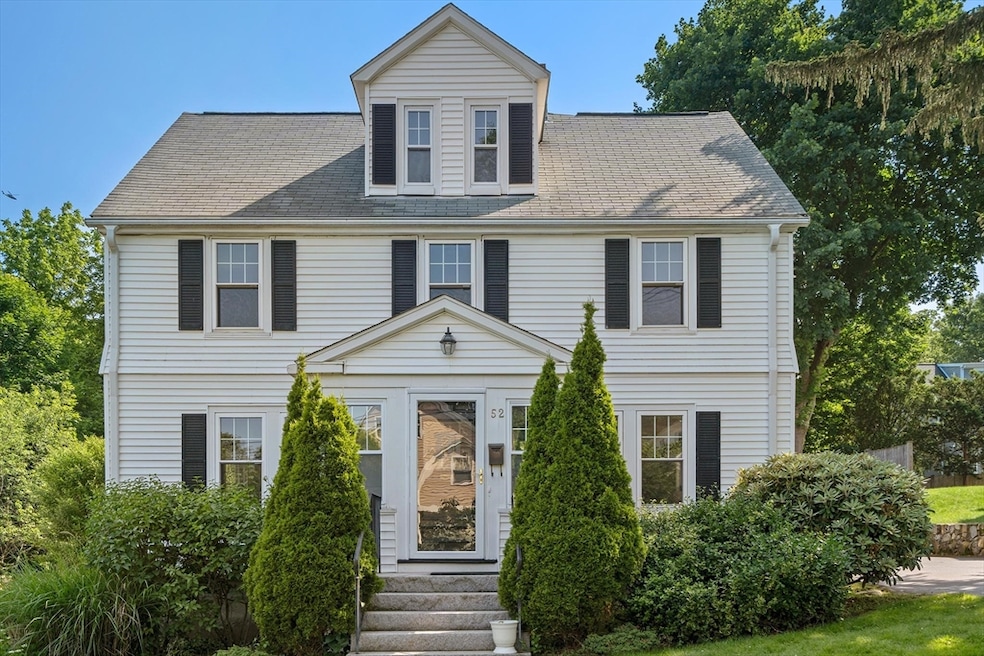
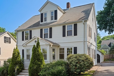
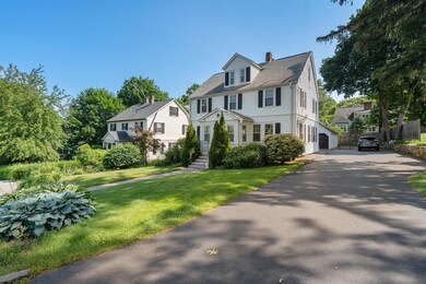
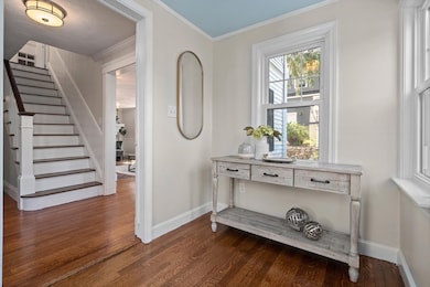
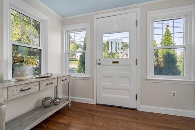
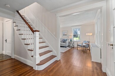
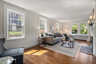
Step into timeless elegance with this charming colonial, ideally located in the Pierce School district. Brimming with natural light and classic details, the home welcomes you with a French-door entry leading to a front-to-back living room with a stately fireplace. The formal dining room features refined moldings and a built-in china cabinet, while the eat-in kitchen offers a bay window and pantry. Enjoy scenic views from the spacious glass-enclosed three-season porch. A large half bath completes the first floor. Upstairs offers four generous bedrooms and a full bath with a skylit walk-in shower. A walk-up attic provides abundant storage, and recent updates include newer windows and a 2008 heating system. There is also a generator connected to the house. This home beautifully blends warmth, character, and convenience. There is a large two car garage with a unfinished loft space above. Located acroos the street from Warren field. Near shopping and highway access.
Last Agent to Sell the Property
Hammond Residential Real Estate Listed on: 06/12/2025
| Date | Type | Sale Price | Title Company |
|---|---|---|---|
| Quit Claim Deed | $1,425,000 | -- | |
| Quit Claim Deed | $1,425,000 | -- | |
| Quit Claim Deed | -- | None Available | |
| Quit Claim Deed | -- | None Available | |
| Quit Claim Deed | -- | None Available | |
| Quit Claim Deed | -- | None Available | |
| Quit Claim Deed | -- | None Available | |
| Quit Claim Deed | -- | None Available |
| Date | Event | Price | List to Sale | Price per Sq Ft |
|---|---|---|---|---|
| 07/11/2025 07/11/25 | Sold | $1,425,000 | -4.9% | $796 / Sq Ft |
| 06/23/2025 06/23/25 | Pending | -- | -- | -- |
| 06/12/2025 06/12/25 | For Sale | $1,499,000 | -- | $837 / Sq Ft |
| Year | Tax Paid | Tax Assessment Tax Assessment Total Assessment is a certain percentage of the fair market value that is determined by local assessors to be the total taxable value of land and additions on the property. | Land | Improvement |
|---|---|---|---|---|
| 2025 | $10,686 | $1,090,400 | $961,500 | $128,900 |
| 2024 | $10,332 | $1,058,600 | $933,500 | $125,100 |
| 2023 | $9,825 | $965,100 | $716,400 | $248,700 |
| 2022 | $9,401 | $893,600 | $663,300 | $230,300 |
| 2021 | $9,071 | $843,000 | $625,800 | $217,200 |
| 2020 | $8,801 | $843,000 | $625,800 | $217,200 |
| 2019 | $8,552 | $818,400 | $607,600 | $210,800 |
| 2018 | $8,220 | $759,700 | $551,600 | $208,100 |
| 2017 | $7,970 | $716,700 | $520,400 | $196,300 |
| 2016 | $7,728 | $679,100 | $486,400 | $192,700 |
| 2015 | $7,369 | $634,700 | $454,600 | $180,100 |
Seller's Agent in 2025
Kennedy Lynch Gold Team
Hammond Residential Real Estate
(617) 699-3564
18 in this area
183 Total Sales
S
Seller Co-Listing Agent in 2025
Sandra Lynch
Hammond Residential Real Estate
(617) 784-2829
2 in this area
16 Total Sales
K
Seller Co-Listing Agent in 2025
Karen Kennedy
Hammond Residential Real Estate
(617) 699-3564
2 in this area
16 Total Sales
M
Seller Co-Listing Agent in 2025
Marjorie Gold
Hammond Residential Real Estate
(617) 549-0181
2 in this area
15 Total Sales
K
Buyer's Agent in 2025
Kiki Williams
Coldwell Banker Realty - Newton
(617) 717-9118
1 in this area
5 Total Sales
Source: MLS Property Information Network (MLS PIN)
MLS Number: 73390313
APN: NEWT-000032-000018-000016
Disclaimer: Certain information contained herein is derived from information provided by parties other than Homes.com. All information provided is deemed reliable, but is not guaranteed to be accurate and should be independently verified.
![]() The property listing data and information, or the Images, set forth herein were provided to MLS Property Information Network, Inc. from third party sources, including sellers, lessors and public records, and were compiled by MLS Property Information Network, Inc. The property listing data and information, and the Images, are for the personal, non-commercial use of consumers having a good faith interest in purchasing or leasing listed properties of the type displayed to them and may not be used for any purpose other than to identify prospective properties which such consumers may have a good faith interest in purchasing or leasing. MLS Property Information Network, Inc. and its subscribers disclaim any and all representations and warranties as to the accuracy of the property listing data and information, or as to the accuracy of any of the Images, set forth herein.
The property listing data and information, or the Images, set forth herein were provided to MLS Property Information Network, Inc. from third party sources, including sellers, lessors and public records, and were compiled by MLS Property Information Network, Inc. The property listing data and information, and the Images, are for the personal, non-commercial use of consumers having a good faith interest in purchasing or leasing listed properties of the type displayed to them and may not be used for any purpose other than to identify prospective properties which such consumers may have a good faith interest in purchasing or leasing. MLS Property Information Network, Inc. and its subscribers disclaim any and all representations and warranties as to the accuracy of the property listing data and information, or as to the accuracy of any of the Images, set forth herein.