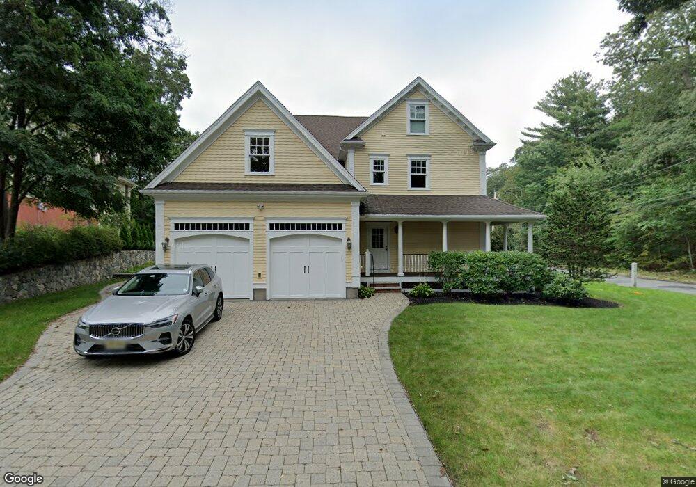
52 N Border Rd Unit 1 Winchester, MA 01890
Winchester Highlands NeighborhoodEstimated Value: $1,363,000 - $3,197,000
6
Beds
5
Baths
5,000
Sq Ft
$492/Sq Ft
Est. Value
About This Home
This home is located at 52 N Border Rd Unit 1, Winchester, MA 01890 and is currently estimated at $2,461,112, approximately $492 per square foot. 52 N Border Rd Unit 1 is a home located in Middlesex County with nearby schools including Muraco Elementary School, McCall Middle School, and Winchester High School.
Ownership History
Date
Name
Owned For
Owner Type
Purchase Details
Closed on
Oct 3, 2008
Sold by
Northeast Dev & Mgmt Llc
Bought by
Marino Matthew F and Marino Palmina
Current Estimated Value
Home Financials for this Owner
Home Financials are based on the most recent Mortgage that was taken out on this home.
Original Mortgage
$825,000
Outstanding Balance
$551,495
Interest Rate
6.54%
Mortgage Type
Purchase Money Mortgage
Estimated Equity
$1,909,617
Purchase Details
Closed on
Apr 25, 2008
Sold by
Northeast Dev & Mgmt Llc
Bought by
Marino Ft
Purchase Details
Closed on
Feb 1, 2007
Sold by
Marita Harry E Chefalo
Bought by
Northeast Dev & Mgmt Llc
Home Financials for this Owner
Home Financials are based on the most recent Mortgage that was taken out on this home.
Original Mortgage
$1,085,000
Interest Rate
6.16%
Mortgage Type
Purchase Money Mortgage
Create a Home Valuation Report for This Property
The Home Valuation Report is an in-depth analysis detailing your home's value as well as a comparison with similar homes in the area
Home Values in the Area
Average Home Value in this Area
Purchase History
| Date | Buyer | Sale Price | Title Company |
|---|---|---|---|
| Marino Matthew F | -- | -- | |
| Marino Ft | -- | -- | |
| Northeast Dev & Mgmt Llc | $619,000 | -- |
Source: Public Records
Mortgage History
| Date | Status | Borrower | Loan Amount |
|---|---|---|---|
| Open | Marino Matthew F | $825,000 | |
| Previous Owner | Northeast Dev & Mgmt Llc | $1,085,000 |
Source: Public Records
Tax History Compared to Growth
Tax History
| Year | Tax Paid | Tax Assessment Tax Assessment Total Assessment is a certain percentage of the fair market value that is determined by local assessors to be the total taxable value of land and additions on the property. | Land | Improvement |
|---|---|---|---|---|
| 2025 | $277 | $2,500,100 | $924,600 | $1,575,500 |
| 2024 | $24,929 | $2,200,300 | $858,500 | $1,341,800 |
| 2023 | $24,474 | $2,074,100 | $759,500 | $1,314,600 |
| 2022 | $24,623 | $1,968,300 | $693,400 | $1,274,900 |
| 2021 | $23,771 | $1,852,800 | $577,900 | $1,274,900 |
| 2020 | $22,546 | $1,819,700 | $544,800 | $1,274,900 |
| 2019 | $21,237 | $1,753,700 | $478,800 | $1,274,900 |
| 2018 | $20,624 | $1,691,900 | $451,600 | $1,240,300 |
| 2017 | $19,798 | $1,612,200 | $425,100 | $1,187,100 |
| 2016 | $18,421 | $1,577,100 | $425,100 | $1,152,000 |
| 2015 | $18,165 | $1,496,300 | $386,300 | $1,110,000 |
| 2014 | $17,914 | $1,415,000 | $322,000 | $1,093,000 |
Source: Public Records
Map
Nearby Homes
- 166 Forest St
- 14 Grant Rd
- 10 Mason Way Unit 61
- 19 Mason Way Unit 75
- 15 Mason Way Unit 73
- 2 Mason Way Unit 6524
- 6 Mason Way Unit 6324
- Southbrook Plan at Highland at Vale - Northfield Collection
- Wheaton Plan at Highland at Vale - Northfield Collection
- Jackson Plan at Highland at Vale - Northfield Collection
- 571 Washington St
- 2 Archer Dr Unit 1
- 9 Washington Ave
- 146 Marble St Unit 213
- 2 Stratton Dr Unit 108
- Lincoln Plan at Highland at Vale - Richfield Collection
- 2 Stratton Dr Unit 1109
- Ivywood Plan at Highland at Vale - Richfield Collection
- Hayden Plan at Highland at Vale - Richfield Collection
- Claremont Plan at Highland at Vale - Richfield Collection