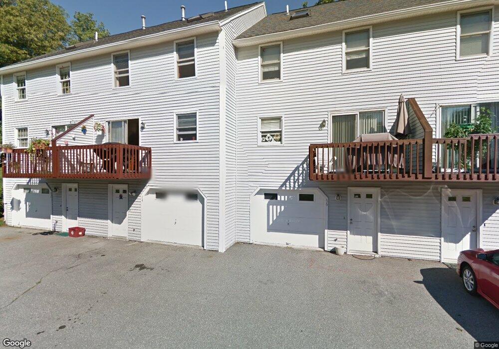
52 Ramsgate Ridge Unit U253 Nashua, NH 03063
Northwest Nashua NeighborhoodEstimated Value: $416,000 - $440,000
3
Beds
2
Baths
1,686
Sq Ft
$257/Sq Ft
Est. Value
About This Home
This home is located at 52 Ramsgate Ridge Unit U253, Nashua, NH 03063 and is currently estimated at $432,903, approximately $256 per square foot. 52 Ramsgate Ridge Unit U253 is a home located in Hillsborough County with nearby schools including Broad Street Elementary School, Pennichuck Middle School, and Nashua High School North.
Ownership History
Date
Name
Owned For
Owner Type
Purchase Details
Closed on
Jun 4, 2018
Sold by
Goulet Gregory J
Bought by
Gregory J Goulet Ret
Current Estimated Value
Purchase Details
Closed on
Jul 1, 2005
Sold by
Hudzin Mark G
Bought by
Goulet Gregory J
Home Financials for this Owner
Home Financials are based on the most recent Mortgage that was taken out on this home.
Original Mortgage
$180,000
Interest Rate
5.73%
Create a Home Valuation Report for This Property
The Home Valuation Report is an in-depth analysis detailing your home's value as well as a comparison with similar homes in the area
Home Values in the Area
Average Home Value in this Area
Purchase History
| Date | Buyer | Sale Price | Title Company |
|---|---|---|---|
| Gregory J Goulet Ret | -- | -- | |
| Goulet Gregory J | $225,000 | -- |
Source: Public Records
Mortgage History
| Date | Status | Borrower | Loan Amount |
|---|---|---|---|
| Previous Owner | Goulet Gregory J | $180,000 |
Source: Public Records
Tax History
| Year | Tax Paid | Tax Assessment Tax Assessment Total Assessment is a certain percentage of the fair market value that is determined by local assessors to be the total taxable value of land and additions on the property. | Land | Improvement |
|---|---|---|---|---|
| 2025 | $6,833 | $406,000 | $0 | $406,000 |
| 2024 | $6,455 | $406,000 | $0 | $406,000 |
| 2023 | $6,175 | $338,700 | $0 | $338,700 |
| 2022 | $6,120 | $338,700 | $0 | $338,700 |
| 2021 | $5,464 | $235,300 | $0 | $235,300 |
| 2020 | $5,320 | $235,300 | $0 | $235,300 |
| 2019 | $5,120 | $235,300 | $0 | $235,300 |
| 2018 | $4,991 | $235,300 | $0 | $235,300 |
| 2017 | $4,134 | $160,300 | $0 | $160,300 |
| 2016 | $4,019 | $160,300 | $0 | $160,300 |
| 2015 | $3,932 | $160,300 | $0 | $160,300 |
| 2014 | $3,855 | $160,300 | $0 | $160,300 |
Source: Public Records
Map
Nearby Homes
- 65 Glastonbury Dr Unit U118
- 35 Albury Stone Cir Unit U201
- 43 Hawkstead Hollow Unit U34
- 33 Cranleigh Mews Unit U311
- 46 Andover Down Unit U286
- 7 Bradford St
- 33 Cannongate Rd Unit 33
- 18 Century Rd
- 5 Dumaine Ave Unit N
- 7 Dumaine Ave Unit H
- 11 Blackstone Dr Unit U1136
- 262 Stonebridge Dr
- 8 Crown Point Cir
- 201 Millwright Dr
- 3 Knights Bridge Dr Unit UL302
- 2 Roedean Dr Unit UA307
- 2 Roedean Dr Unit UA303
- 4 Knights Bridge Dr Unit UI206
- 7 Mount Vernon St
- 14 Terry St
- 54 Ramsgate Ridge Unit U254
- 56 Ramsgate Ridge Unit U255
- 50 Ramsgate Ridge Unit U252
- 48 Ramsgate Ridge Unit U251
- 60 Ramsgate Ridge Unit U257
- 60 Ramsgate Ridge Dr Unit 60
- 72 Ramsgate Ridge Unit U263
- 62 Ramsgate Ridge Unit U258
- 74 Ramsgate Ridge Unit U264
- 70 Ramsgate Ridge Unit U262
- 46 Ramsgate Ridge Unit U250
- 68 Ramsgate Ridge Unit U261
- 64 Ramsgate Ridge Unit U259
- 66 Ramsgate Ridge Unit U260
- 44 Ramsgate Ridge Unit U249
- 44 Ramsgate Ridge Unit 44
- 68 Ramsgate Ridge Dr Unit 261
- 28 Ramsgate Ridge Unit U241
- 30 Ramsgate Ridge Unit U242
- 42 Ramsgate Ridge Unit U248
Your Personal Tour Guide
Ask me questions while you tour the home.