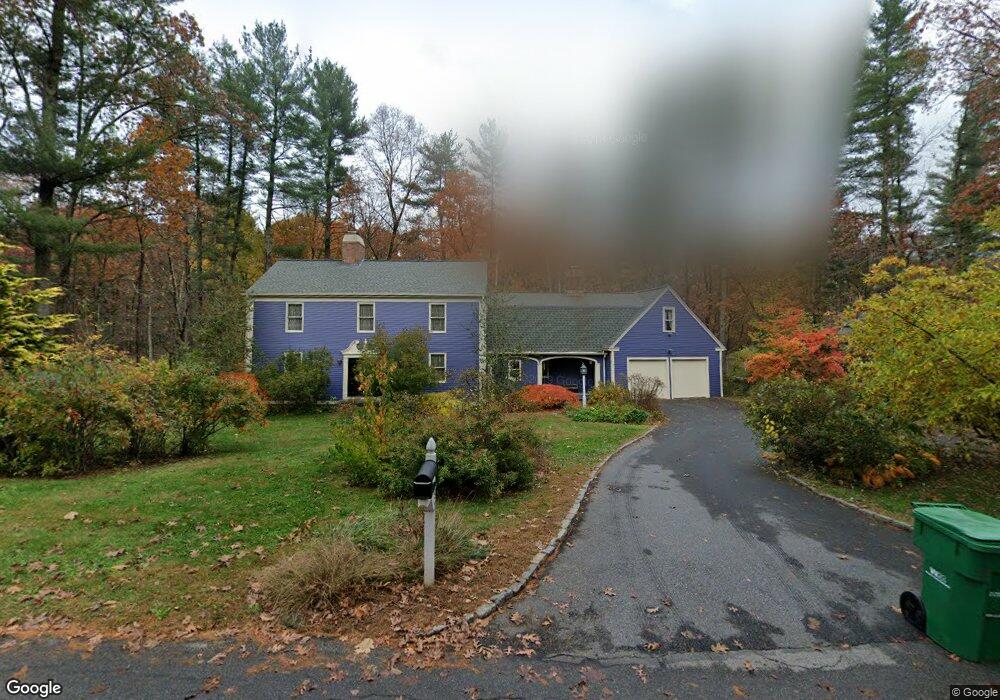
52 Ruddock Rd Sudbury, MA 01776
Estimated Value: $1,091,000 - $2,096,000
4
Beds
3
Baths
2,770
Sq Ft
$536/Sq Ft
Est. Value
About This Home
This home is located at 52 Ruddock Rd, Sudbury, MA 01776 and is currently estimated at $1,484,043, approximately $535 per square foot. 52 Ruddock Rd is a home located in Middlesex County with nearby schools including Josiah Haynes Elementary School, Ephraim Curtis Middle School, and Lincoln-Sudbury Regional High School.
Ownership History
Date
Name
Owned For
Owner Type
Purchase Details
Closed on
Sep 26, 1997
Sold by
Flynn Gerard J and Flynn Carol A
Bought by
Meuse Kevin M and Wong Susan Y
Current Estimated Value
Home Financials for this Owner
Home Financials are based on the most recent Mortgage that was taken out on this home.
Original Mortgage
$371,200
Outstanding Balance
$55,296
Interest Rate
7.47%
Mortgage Type
Purchase Money Mortgage
Estimated Equity
$1,428,747
Purchase Details
Closed on
Jul 1, 1994
Sold by
Ford Willard L and Ford Nancy R
Bought by
Flynn Gerard J and Flynn Carol A
Create a Home Valuation Report for This Property
The Home Valuation Report is an in-depth analysis detailing your home's value as well as a comparison with similar homes in the area
Home Values in the Area
Average Home Value in this Area
Purchase History
| Date | Buyer | Sale Price | Title Company |
|---|---|---|---|
| Meuse Kevin M | $464,000 | -- | |
| Meuse Kevin M | $464,000 | -- | |
| Flynn Gerard J | $445,000 | -- | |
| Flynn Gerard J | $445,000 | -- |
Source: Public Records
Mortgage History
| Date | Status | Borrower | Loan Amount |
|---|---|---|---|
| Open | Flynn Gerard J | $197,000 | |
| Open | Flynn Gerard J | $371,200 | |
| Closed | Flynn Gerard J | $371,200 |
Source: Public Records
Tax History
| Year | Tax Paid | Tax Assessment Tax Assessment Total Assessment is a certain percentage of the fair market value that is determined by local assessors to be the total taxable value of land and additions on the property. | Land | Improvement |
|---|---|---|---|---|
| 2025 | $17,911 | $1,223,400 | $501,200 | $722,200 |
| 2024 | $17,247 | $1,180,500 | $486,800 | $693,700 |
| 2023 | $16,013 | $1,015,400 | $434,800 | $580,600 |
| 2022 | $15,565 | $862,300 | $398,800 | $463,500 |
| 2021 | $14,838 | $788,000 | $398,800 | $389,200 |
| 2020 | $14,539 | $788,000 | $398,800 | $389,200 |
| 2019 | $14,113 | $788,000 | $398,800 | $389,200 |
| 2018 | $13,982 | $779,800 | $424,400 | $355,400 |
| 2017 | $13,709 | $772,800 | $420,800 | $352,000 |
| 2016 | $13,291 | $746,700 | $404,800 | $341,900 |
| 2015 | $12,818 | $728,300 | $393,200 | $335,100 |
| 2014 | $12,799 | $709,900 | $381,600 | $328,300 |
Source: Public Records
Map
Nearby Homes
- 96 Mossman Rd
- 40 Widow Rites Ln
- 41 Old Coach Rd
- 55 Widow Rites Ln
- 377 Willis Rd
- 48 Chanticleer Rd
- 355 Maynard Rd
- 228 Mossman Rd
- 6 Canterbury Dr
- 68 Longfellow Rd
- 20 Cobblestone Place
- 45 Webster Cir
- 8 Snowberry Ln
- 22 Hilltop Rd
- 11 October Rd
- 42 Dakin Rd
- 19 Skyview Ln
- 30 Harness Ln
- 62 Churchill St
- 8 Twillingate Rd
Your Personal Tour Guide
Ask me questions while you tour the home.