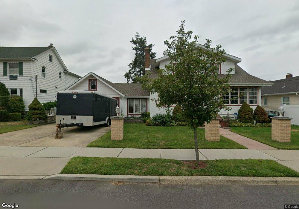
52 W Grove Ave Maywood, NJ 07607
Estimated Value: $751,241 - $842,000
--
Bed
--
Bath
2,048
Sq Ft
$383/Sq Ft
Est. Value
About This Home
This home is located at 52 W Grove Ave, Maywood, NJ 07607 and is currently estimated at $784,060, approximately $382 per square foot. 52 W Grove Ave is a home located in Bergen County with nearby schools including Memorial Elementary School, Maywood Avenue Elementary School, and Ben Porat Yosef.
Ownership History
Date
Name
Owned For
Owner Type
Purchase Details
Closed on
Oct 2, 2006
Sold by
Carrasco Enrique
Bought by
Carrasco Margarita
Current Estimated Value
Home Financials for this Owner
Home Financials are based on the most recent Mortgage that was taken out on this home.
Original Mortgage
$171,000
Outstanding Balance
$102,490
Interest Rate
6.54%
Estimated Equity
$681,570
Create a Home Valuation Report for This Property
The Home Valuation Report is an in-depth analysis detailing your home's value as well as a comparison with similar homes in the area
Home Values in the Area
Average Home Value in this Area
Purchase History
| Date | Buyer | Sale Price | Title Company |
|---|---|---|---|
| Carrasco Margarita | $220,000 | -- | |
| -- | -- | -- |
Source: Public Records
Mortgage History
| Date | Status | Borrower | Loan Amount |
|---|---|---|---|
| Open | -- | $171,000 |
Source: Public Records
Tax History Compared to Growth
Tax History
| Year | Tax Paid | Tax Assessment Tax Assessment Total Assessment is a certain percentage of the fair market value that is determined by local assessors to be the total taxable value of land and additions on the property. | Land | Improvement |
|---|---|---|---|---|
| 2025 | $13,297 | $660,400 | $322,500 | $337,900 |
| 2024 | $12,763 | $617,900 | $300,600 | $317,300 |
| 2023 | $12,332 | $592,800 | $287,500 | $305,300 |
| 2022 | $12,332 | $540,400 | $262,500 | $277,900 |
| 2021 | $11,471 | $502,600 | $235,000 | $267,600 |
| 2020 | $12,296 | $389,100 | $192,100 | $197,000 |
| 2019 | $12,109 | $389,100 | $192,100 | $197,000 |
| 2018 | $11,840 | $389,100 | $192,100 | $197,000 |
| 2017 | $11,650 | $389,100 | $192,100 | $197,000 |
| 2016 | $11,292 | $389,100 | $192,100 | $197,000 |
| 2015 | $10,980 | $389,100 | $192,100 | $197,000 |
| 2014 | $10,825 | $389,100 | $192,100 | $197,000 |
Source: Public Records
Map
Nearby Homes
- 37 Terrace Ave
- 115 Parkway
- 46 Woodland Ave
- 49 E Pleasant Ave
- 644 Wyoming Ave
- 642 Spring Valley Rd
- 493 W Anderson St
- 137 Hartwich St
- 350 Maywood Ave
- 446 Passaic St Unit 1A
- 420 Passaic St Unit 2G
- 483 Colonial Terrace Unit 10
- 269 Poplar Ave
- 467 Summit Ave
- 486 Blanchard Terrace Unit 70
- 25 Marinus St
- 47 Colling Ave
- 293 Euclid Ave
- 29 Colling Ave
- 290 Clinton Place