Estimated Value: $260,063 - $280,000
3
Beds
3
Baths
1,764
Sq Ft
$153/Sq Ft
Est. Value
About This Home
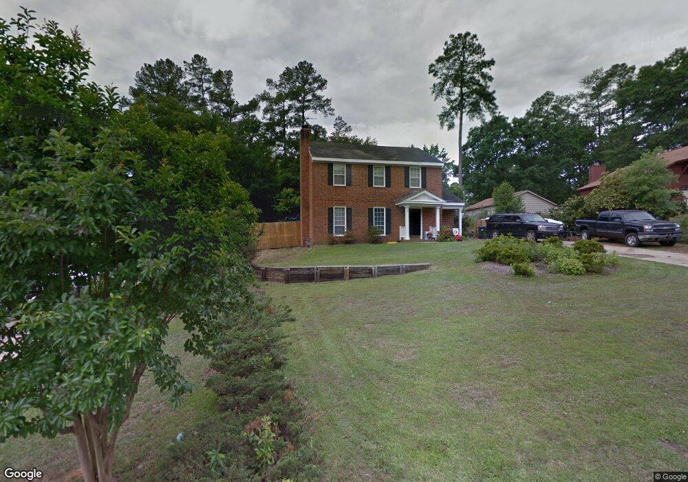
This home is located at 520 Fairfield Way, Evans, GA 30809 and is currently estimated at $270,016, approximately $153 per square foot. 520 Fairfield Way is a home with nearby schools including Northmore Elementary School, Lincoln Elementary School, and Blue Ridge Elementary School.
Ownership History
Date
Name
Owned For
Owner Type
Purchase Details
Closed on
Jun 16, 2020
Sold by
Odum Mollie
Bought by
Odum Robert Leslie
Current Estimated Value
Purchase Details
Closed on
Jul 28, 2008
Sold by
Etterlee Walter C
Bought by
Odum Robert L
Home Financials for this Owner
Home Financials are based on the most recent Mortgage that was taken out on this home.
Original Mortgage
$145,221
Interest Rate
6.43%
Mortgage Type
FHA
Purchase Details
Closed on
Aug 26, 2002
Sold by
Etterlee Walter C
Bought by
Etterlee Ingrid T
Home Financials for this Owner
Home Financials are based on the most recent Mortgage that was taken out on this home.
Original Mortgage
$88,600
Interest Rate
6.4%
Create a Home Valuation Report for This Property
The Home Valuation Report is an in-depth analysis detailing your home's value as well as a comparison with similar homes in the area
Home Values in the Area
Average Home Value in this Area
Purchase History
| Date | Buyer | Sale Price | Title Company |
|---|---|---|---|
| Odum Robert Leslie | -- | -- | |
| Odum Robert L | $147,500 | -- | |
| Etterlee Ingrid T | -- | -- |
Source: Public Records
Mortgage History
| Date | Status | Borrower | Loan Amount |
|---|---|---|---|
| Previous Owner | Odum Robert L | $145,221 | |
| Previous Owner | Etterlee Ingrid T | $88,600 |
Source: Public Records
Tax History Compared to Growth
Tax History
| Year | Tax Paid | Tax Assessment Tax Assessment Total Assessment is a certain percentage of the fair market value that is determined by local assessors to be the total taxable value of land and additions on the property. | Land | Improvement |
|---|---|---|---|---|
| 2025 | $2,244 | $91,611 | $20,304 | $71,307 |
| 2024 | $2,267 | $88,366 | $19,004 | $69,362 |
| 2023 | $2,267 | $82,736 | $17,604 | $65,132 |
| 2022 | $1,956 | $72,994 | $14,804 | $58,190 |
| 2021 | $1,819 | $64,732 | $13,804 | $50,928 |
| 2020 | $1,758 | $61,184 | $13,004 | $48,180 |
| 2019 | $1,745 | $60,738 | $12,404 | $48,334 |
| 2018 | $1,543 | $53,288 | $12,104 | $41,184 |
| 2017 | $1,599 | $55,077 | $11,204 | $43,873 |
| 2016 | $1,466 | $52,184 | $10,480 | $41,704 |
| 2015 | $1,422 | $50,466 | $9,980 | $40,486 |
| 2014 | $1,357 | $47,450 | $9,780 | $37,670 |
Source: Public Records
Map
Nearby Homes
- 4157 Arlington Rd
- 368 Sumac Trail
- 358 Sumac Trail
- 333 Sumac Trail
- 155 Canton Park Ave
- 4209 Fairfield Cir
- 418 Santa Anna Trail
- 598 Bradford Ln
- 0 Commons Dr
- 4190 Litchfield Ln
- 323 Connor Cir
- 317 Connor Cir
- 4063 Danielle Dr
- 4069 Riverwatch Pkwy
- 579 Litchfield Ct
- 4070 Riverwatch Pkwy
- 386 Connor Cir
- 593 Blue Ridge Crossing
- 367 Connor Cir
- 4116 Dunes Dr
- 518 Fairfield Way
- 522 Fairfield Way
- 532 Adams Mill Ln
- 516 Fairfield Way
- 524 Fairfield Way
- 521 Fairfield Way
- 519 Fairfield Way
- 4151 Arlington Rd
- 523 Fairfield Way
- 528 Adams Mill Ln
- 517 Fairfield Way
- 4153 Arlington Rd
- 4235 Fairfield Cir
- 525 Fairfield Way
- 525 Adams Mill Ln
- 515 Fairfield Way
- 526 Adams Mill Ln
- 4155 Arlington Rd
- 4233 Fairfield Cir
- 4146 Arlington Rd