520 Niagara Cir Alpharetta, GA 30022
Rivermont NeighborhoodEstimated payment $3,806/month
Highlights
- Airport or Runway
- On Golf Course
- Clubhouse
- Barnwell Elementary School Rated A
- Home fronts a pond
- Deck
About This Home
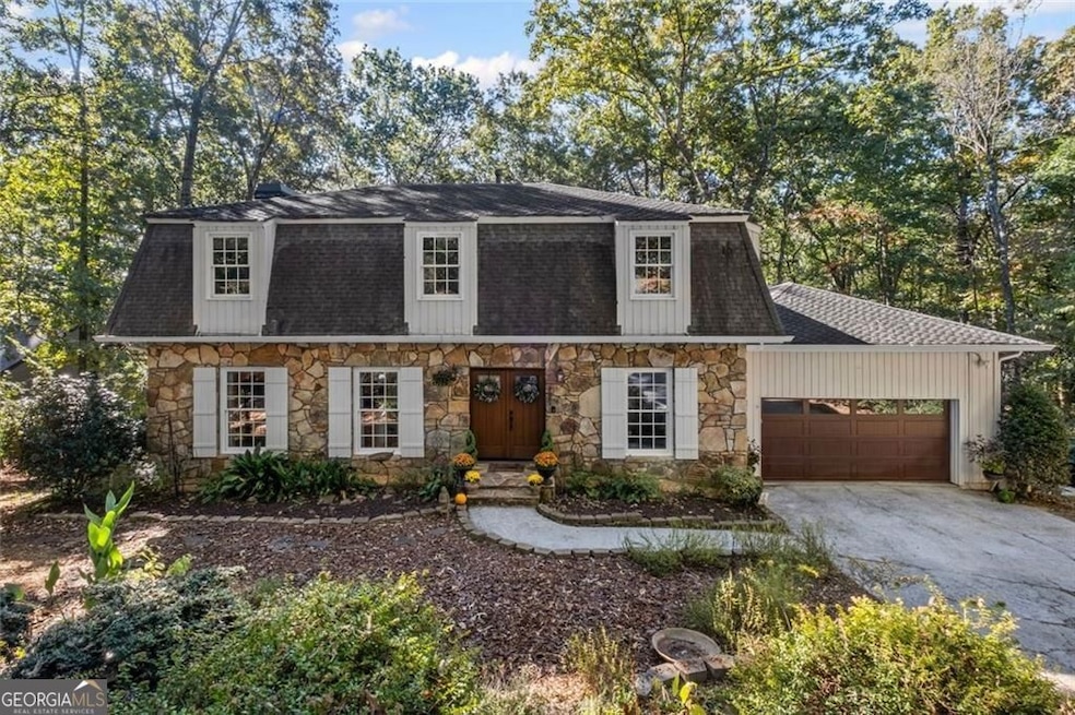
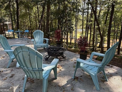
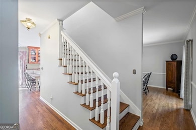
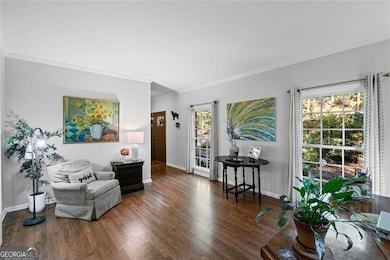
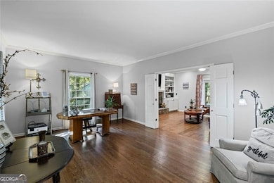
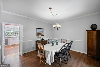
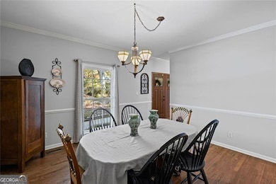
Welcome to this elegant golf course retreat in the highly desirable Rivermont community of Johns Creek, recently ranked the #1 Best Place to Live in America by U.S. News & World Report. Perfectly situated on a wooded three-quarter acre cul-de-sac lot, this home offers an inviting open-concept design with a renovated kitchen, hardwood floors on the main level, and energy-efficient double-pane windows throughout. A full-length deck runs along the rear of the home, providing sweeping views of the golf course and an ideal space for entertaining or relaxing. Upstairs you will find the owner's suite, with its beautifully updated bath including a separate tankless water heater and heated flooring, three additional spacious bedrooms, and updated guest bath with generous closet space in every room. The finished terrace level offers an additional bedroom, a playfully updated full bath, a large recreation area with warm wood paneling and access to an expansive patio leading down to a private sports court-perfect for bocce ball, cornhole, or simply enjoying the outdoors around a firepit. And let's don't forget the cozy little treehouse! Rivermont residents enjoy outstanding amenities including a clubhouse, pool, tennis courts, plus a residents-only 27-acre park along the banks of the Chattahoochee River. With wide, tree-lined streets, a serene wooded setting, and a prime location close to top-rated schools, shopping, and dining, this home offers the perfect balance of luxury, lifestyle, and convenience. Optional membership at the Rivermont Golf Club provides access to golf, another pool, pickleball, pilates studio, practice ranges and on-site dining.
Listing Agent
BHHS Georgia Properties Brokerage Phone: License #102892 Listed on: 10/14/2025

Home Details
Home Type
- Single Family
Est. Annual Taxes
- $3,920
Year Built
- Built in 1975
Lot Details
- 0.73 Acre Lot
- Home fronts a pond
- On Golf Course
- Cul-De-Sac
- Wooded Lot
Parking
- 2 Car Garage
Home Design
- Traditional Architecture
- Slab Foundation
- Composition Roof
Interior Spaces
- 2-Story Property
- Bookcases
- 1 Fireplace
- Family Room
- Laundry Room
Kitchen
- Breakfast Bar
- Dishwasher
Flooring
- Wood
- Carpet
Bedrooms and Bathrooms
- Walk-In Closet
- Double Vanity
Finished Basement
- Exterior Basement Entry
- Natural lighting in basement
Outdoor Features
- Deck
- Patio
- Outbuilding
Schools
- Barnwell Elementary School
- Haynes Bridge Middle School
- Centennial High School
Utilities
- Forced Air Heating and Cooling System
- Heating System Uses Natural Gas
- Underground Utilities
- High-Efficiency Water Heater
- Gas Water Heater
- Phone Available
- Cable TV Available
Listing and Financial Details
- Legal Lot and Block 54 / C
Community Details
Overview
- Property has a Home Owners Association
- Association fees include tennis
- Rivermont Subdivision
Amenities
- Airport or Runway
- Clubhouse
- No Laundry Facilities
Recreation
- Golf Course Community
- Tennis Courts
- Community Pool
Map
Home Values in the Area
Average Home Value in this Area
Tax History
| Year | Tax Paid | Tax Assessment Tax Assessment Total Assessment is a certain percentage of the fair market value that is determined by local assessors to be the total taxable value of land and additions on the property. | Land | Improvement |
|---|---|---|---|---|
| 2025 | $3,920 | $211,080 | $68,560 | $142,520 |
| 2023 | $6,824 | $241,760 | $94,920 | $146,840 |
| 2022 | $3,744 | $181,640 | $51,600 | $130,040 |
| 2021 | $3,716 | $169,240 | $47,720 | $121,520 |
| 2020 | $3,741 | $158,400 | $30,440 | $127,960 |
| 2019 | $433 | $155,640 | $29,920 | $125,720 |
| 2018 | $4,372 | $151,960 | $29,200 | $122,760 |
| 2017 | $3,502 | $115,040 | $21,280 | $93,760 |
| 2016 | $3,443 | $115,040 | $21,280 | $93,760 |
| 2015 | $3,480 | $115,040 | $21,280 | $93,760 |
| 2014 | $2,841 | $93,600 | $19,440 | $74,160 |
Property History
| Date | Event | Price | List to Sale | Price per Sq Ft |
|---|---|---|---|---|
| 11/05/2025 11/05/25 | Price Changed | $660,000 | -2.8% | $169 / Sq Ft |
| 10/14/2025 10/14/25 | For Sale | $679,000 | 0.0% | $174 / Sq Ft |
| 10/14/2025 10/14/25 | Price Changed | $679,000 | -- | $174 / Sq Ft |
Purchase History
| Date | Type | Sale Price | Title Company |
|---|---|---|---|
| Deed | $255,000 | -- | |
| Deed | $173,000 | -- |
Mortgage History
| Date | Status | Loan Amount | Loan Type |
|---|---|---|---|
| Previous Owner | $250,381 | FHA | |
| Closed | -- | No Value Available |
Source: Georgia MLS
MLS Number: 10618462
APN: 12-3072-0888-029-8
Disclaimer: Certain information contained herein is derived from information provided by parties other than Homes.com. All information provided is deemed reliable, but is not guaranteed to be accurate and should be independently verified.
![]() The data relating to real estate for sale on this web site comes in part from the Broker Reciprocity Program of Georgia MLS. Real estate listings held by brokerage firms other than Redfin are marked with the Broker Reciprocity logo and detailed information about them includes the name of the listing brokers. Information deemed reliable but not guaranteed. Copyright 2025 Georgia MLS. All rights reserved.
The data relating to real estate for sale on this web site comes in part from the Broker Reciprocity Program of Georgia MLS. Real estate listings held by brokerage firms other than Redfin are marked with the Broker Reciprocity logo and detailed information about them includes the name of the listing brokers. Information deemed reliable but not guaranteed. Copyright 2025 Georgia MLS. All rights reserved.
- 3055 Rivermont Pkwy
- 930 Tiber Cir
- 180 Colony Ridge Dr
- 240 Fairway Ridge Dr
- 9025 Niblic Dr
- 712 Cypress Pointe St
- 703 Cypress Pointe St Unit 123
- 530 Matterhorn Way
- 2930 Sawtooth Cir
- 1106 Sandy Lane Dr Unit 206
- 606 Cypress Pointe St
- 765 Olde Clubs Dr
- 1003 Sandy Lane Dr
- 2895 Shurburne Dr
- 0 Niblick Dr Unit 7655286
- 9155 Nesbit Ferry Rd Unit 96
- 1213 Waterville Ct Unit 233
- 1213 Waterville Ct
- 1112 Sandy Ln Dr
- 515 Cypress Pointe St
- 509 Cypress Pointe St
- 9155 Nesbit Ferry Rd Unit 57
- 9155 Nesbit Ferry Rd Unit 127
- 219 Saint Andrews Ct
- 2845 Holcomb Bridge Rd
- 2745 Holcomb Bridge Rd
- 279 Devonshire Dr
- 8520 S Holcomb Bridge Way
- 2745 Holcomb Bridge Rd Unit 1333.1410846
- 2745 Holcomb Bridge Rd Unit 1332.1410843
- 2745 Holcomb Bridge Rd Unit 914.1410842
- 2745 Holcomb Bridge Rd Unit 1623.1410844
- 9026 Riverbend Manor
- 100 Saratoga Dr
- 642 Granby Hill Place
- 2600 Holcomb Bridge Rd