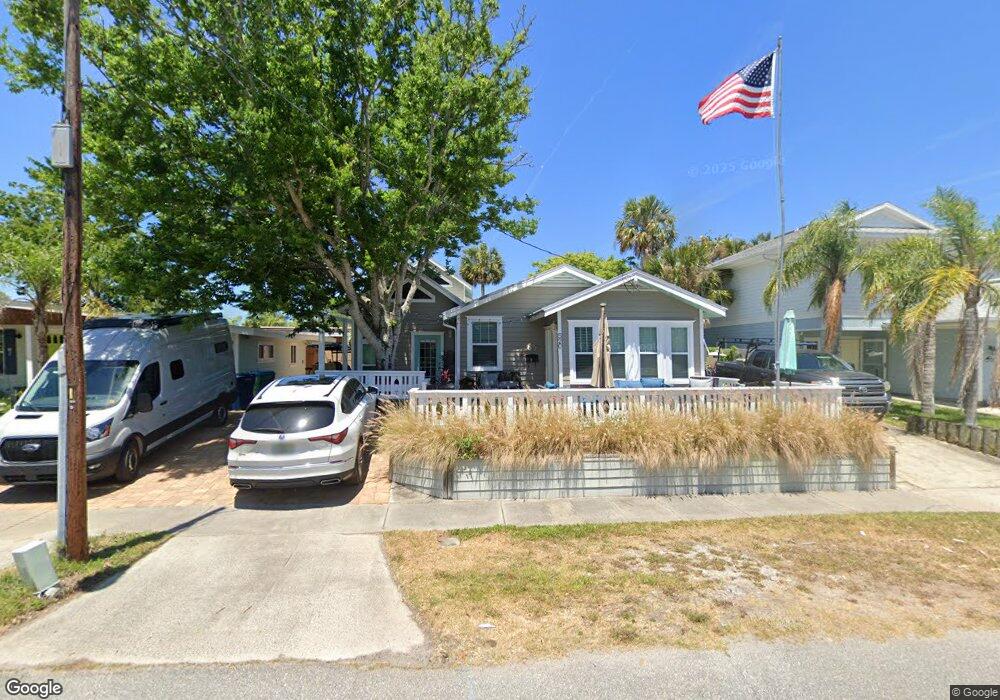
520 Oleander St Neptune Beach, FL 32266
Estimated Value: $637,000 - $801,000
3
Beds
2
Baths
1,931
Sq Ft
$378/Sq Ft
Est. Value
About This Home
This home is located at 520 Oleander St, Neptune Beach, FL 32266 and is currently estimated at $729,033, approximately $377 per square foot. 520 Oleander St is a home located in Duval County with nearby schools including Neptune Beach Elementary School, Duncan U. Fletcher Middle School, and Duncan U. Fletcher High School.
Ownership History
Date
Name
Owned For
Owner Type
Purchase Details
Closed on
Jun 8, 2006
Sold by
Tuttle Douglas Paul and Tuttle Nancy H
Bought by
Tuttle Douglas Paul and Tuttle Nancy H
Current Estimated Value
Home Financials for this Owner
Home Financials are based on the most recent Mortgage that was taken out on this home.
Original Mortgage
$256,500
Interest Rate
6.62%
Mortgage Type
Purchase Money Mortgage
Create a Home Valuation Report for This Property
The Home Valuation Report is an in-depth analysis detailing your home's value as well as a comparison with similar homes in the area
Home Values in the Area
Average Home Value in this Area
Purchase History
| Date | Buyer | Sale Price | Title Company |
|---|---|---|---|
| Tuttle Douglas Paul | $125,000 | North Florida Title Svcs Inc |
Source: Public Records
Mortgage History
| Date | Status | Borrower | Loan Amount |
|---|---|---|---|
| Closed | Tuttle Douglas Paul | $256,500 |
Source: Public Records
Tax History
| Year | Tax Paid | Tax Assessment Tax Assessment Total Assessment is a certain percentage of the fair market value that is determined by local assessors to be the total taxable value of land and additions on the property. | Land | Improvement |
|---|---|---|---|---|
| 2026 | $1,820 | $143,742 | -- | -- |
| 2025 | $1,768 | $143,742 | -- | -- |
| 2024 | $1,705 | $139,691 | -- | -- |
| 2023 | $1,705 | $135,623 | $0 | $0 |
| 2022 | $1,534 | $131,673 | $0 | $0 |
| 2021 | $1,513 | $127,838 | $0 | $0 |
| 2020 | $1,493 | $126,073 | $0 | $0 |
| 2019 | $1,468 | $123,239 | $0 | $0 |
| 2018 | $1,441 | $120,942 | $0 | $0 |
| 2017 | $1,415 | $118,455 | $0 | $0 |
| 2016 | $1,401 | $116,019 | $0 | $0 |
| 2015 | $1,415 | $115,213 | $0 | $0 |
| 2014 | $1,415 | $114,299 | $0 | $0 |
Source: Public Records
Map
Nearby Homes
- 404 Margaret St
- 552 Seagate Ave
- 527 Florida Blvd
- 230 Davis St
- 229 Margaret St
- 240 Hopkins St
- 206 Hopkins St
- 1914 1st St
- 215 19th Ave N Unit B
- 1408 Strand St
- 1403 Ocean Front
- 1024 Neptune Ln
- 26 20th Ave N
- 123 18th Ave N
- 11 19th Ave N
- 300 Bay St
- 1102 Ocean Front
- 1901 1st St N Unit 1002
- 1901 1st St N Unit 203
- 1901 1st St N Unit 902
Your Personal Tour Guide
Ask me questions while you tour the home.