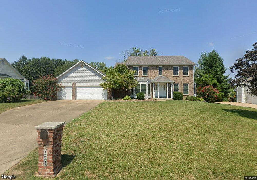
5204 Roanoke Dr Weldon Spring, MO 63304
Estimated Value: $557,904 - $615,000
4
Beds
5
Baths
2,788
Sq Ft
$211/Sq Ft
Est. Value
About This Home
This home is located at 5204 Roanoke Dr, Weldon Spring, MO 63304 and is currently estimated at $588,726, approximately $211 per square foot. 5204 Roanoke Dr is a home located in St. Charles County with nearby schools including Independence Elementary School, Bryan Middle School, and Francis Howell Union High School.
Ownership History
Date
Name
Owned For
Owner Type
Purchase Details
Closed on
Oct 16, 2012
Sold by
Raines Clyde R and Raines Verna M
Bought by
Brown Michael A and Brown Rachel Y
Current Estimated Value
Home Financials for this Owner
Home Financials are based on the most recent Mortgage that was taken out on this home.
Original Mortgage
$195,000
Outstanding Balance
$33,778
Interest Rate
3.61%
Mortgage Type
New Conventional
Estimated Equity
$554,948
Create a Home Valuation Report for This Property
The Home Valuation Report is an in-depth analysis detailing your home's value as well as a comparison with similar homes in the area
Home Values in the Area
Average Home Value in this Area
Purchase History
| Date | Buyer | Sale Price | Title Company |
|---|---|---|---|
| Brown Michael A | $260,000 | Assured Title Company |
Source: Public Records
Mortgage History
| Date | Status | Borrower | Loan Amount |
|---|---|---|---|
| Open | Brown Michael A | $195,000 |
Source: Public Records
Tax History
| Year | Tax Paid | Tax Assessment Tax Assessment Total Assessment is a certain percentage of the fair market value that is determined by local assessors to be the total taxable value of land and additions on the property. | Land | Improvement |
|---|---|---|---|---|
| 2025 | $5,470 | $99,589 | -- | -- |
| 2023 | $5,468 | $91,797 | $0 | $0 |
| 2022 | $5,077 | $79,164 | $0 | $0 |
| 2021 | $5,081 | $79,164 | $0 | $0 |
| 2020 | $4,474 | $67,430 | $0 | $0 |
| 2019 | $4,454 | $67,430 | $0 | $0 |
| 2018 | $4,524 | $65,496 | $0 | $0 |
| 2017 | $4,487 | $65,496 | $0 | $0 |
| 2016 | $4,145 | $58,253 | $0 | $0 |
| 2015 | $4,109 | $58,253 | $0 | $0 |
| 2014 | $3,578 | $49,207 | $0 | $0 |
Source: Public Records
Map
Nearby Homes
- 102 Enclave Terrace Ct
- 828 Nancy Ln
- 3624 Capri Way
- 3424 Capri Way
- 74 W Meath Ring
- 59 W Meath Ring
- 16 Knollwood Ct
- 323 San Marco Way
- 5013 Royal Burgess Dr
- 21 Knollwood Ct
- 149 Shaelah Ct
- 4923 Dresden Way
- 265 Camelot Dr
- 1317 Renaissance Place
- 862 Whitmoor Dr
- 5527 Hennsley Cir
- 1248 Shirley Ridge Dr Unit 7C
- 1094 Whitmoor Dr
- 6 Whitmoor Ct
- 5534 Wavecrest Cir
- 5200 Roanoke Dr
- 5208 Roanoke Dr
- 5212 Roanoke Dr
- 5201 Roanoke Dr
- 5213 Roanoke Dr
- 5212 Shetland Dr
- 5216 Roanoke Dr
- 11 Wolfrum Rd 5 2 Rd Unit 5.2ac
- 11 Wolfrum Rd 5 2 Rd
- 12 New Haven Ct
- 4 Balmore Ct
- 5210 Shetland Dr
- 11 New Haven Ct
- 5217 Roanoke Dr
- 5398 Wolfrum Way
- 5220 Roanoke Dr
- 14 New Haven Ct
- 5394 Wolfrum Way
- 3 Balmore Ct
- 22 Leesburg Ct
Your Personal Tour Guide
Ask me questions while you tour the home.