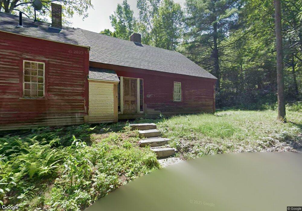
521 Jones Cemetery Rd Orange, MA 01364
Estimated Value: $290,000 - $391,000
3
Beds
1
Bath
1,722
Sq Ft
$198/Sq Ft
Est. Value
About This Home
This home is located at 521 Jones Cemetery Rd, Orange, MA 01364 and is currently estimated at $340,714, approximately $197 per square foot. 521 Jones Cemetery Rd is a home located in Franklin County with nearby schools including Fisher Hill and Ralph C Mahar Regional School.
Ownership History
Date
Name
Owned For
Owner Type
Purchase Details
Closed on
May 15, 2024
Sold by
Fraser Clara F Est and Bishop
Bought by
Fraser Alexandra
Current Estimated Value
Purchase Details
Closed on
Jan 28, 1999
Sold by
Lacombe Brian M and Lacombe Renee H
Bought by
Fraser Clara F
Purchase Details
Closed on
Sep 3, 1993
Sold by
Herbert Jeffrey P
Bought by
Lacombe Brian M and Lacombe Renee H
Home Financials for this Owner
Home Financials are based on the most recent Mortgage that was taken out on this home.
Original Mortgage
$43,000
Interest Rate
7.11%
Mortgage Type
Purchase Money Mortgage
Create a Home Valuation Report for This Property
The Home Valuation Report is an in-depth analysis detailing your home's value as well as a comparison with similar homes in the area
Home Values in the Area
Average Home Value in this Area
Purchase History
| Date | Buyer | Sale Price | Title Company |
|---|---|---|---|
| Fraser Alexandra | -- | None Available | |
| Fraser Alexandra | -- | None Available | |
| Fraser Clara F | $79,000 | -- | |
| Lacombe Brian M | $62,500 | -- | |
| Fraser Clara F | $79,000 | -- | |
| Lacombe Brian M | $62,500 | -- |
Source: Public Records
Mortgage History
| Date | Status | Borrower | Loan Amount |
|---|---|---|---|
| Previous Owner | Lacombe Brian M | $43,000 |
Source: Public Records
Tax History Compared to Growth
Tax History
| Year | Tax Paid | Tax Assessment Tax Assessment Total Assessment is a certain percentage of the fair market value that is determined by local assessors to be the total taxable value of land and additions on the property. | Land | Improvement |
|---|---|---|---|---|
| 2025 | $37 | $226,300 | $37,000 | $189,300 |
| 2024 | $4,109 | $235,600 | $37,000 | $198,600 |
| 2023 | $3,727 | $207,500 | $37,000 | $170,500 |
| 2022 | $3,853 | $201,500 | $37,000 | $164,500 |
| 2021 | $3,906 | $194,800 | $53,600 | $141,200 |
| 2020 | $3,832 | $188,500 | $53,200 | $135,300 |
| 2019 | $191 | $168,600 | $46,300 | $122,300 |
| 2018 | $3,686 | $168,000 | $43,300 | $124,700 |
| 2017 | $3,567 | $168,000 | $43,300 | $124,700 |
| 2016 | $3,426 | $157,900 | $43,300 | $114,600 |
| 2015 | $3,280 | $157,900 | $43,300 | $114,600 |
| 2014 | $2,894 | $146,600 | $43,300 | $103,300 |
Source: Public Records
Map
Nearby Homes
- 260 East Rd
- 900 N Main St
- 52 Creamery Hill Rd
- LOT Walnut Hill
- 15 Tully Rd
- 15 A-B Tully Rd
- 0 Oxbow Unit 73446570
- 31 Pinedale Rd
- 660 Pinedale Ave
- 153 Dana Rd
- 38 Twichell St
- 330 N Orange Rd
- 140 Mechanic St
- 102 Mechanic St
- 23 Mount Pleasant St
- 0 Adams Dr
- 340 Brickyard Rd
- 52 Mechanic St
- 520 Lenox St
- 31 Locke Ave