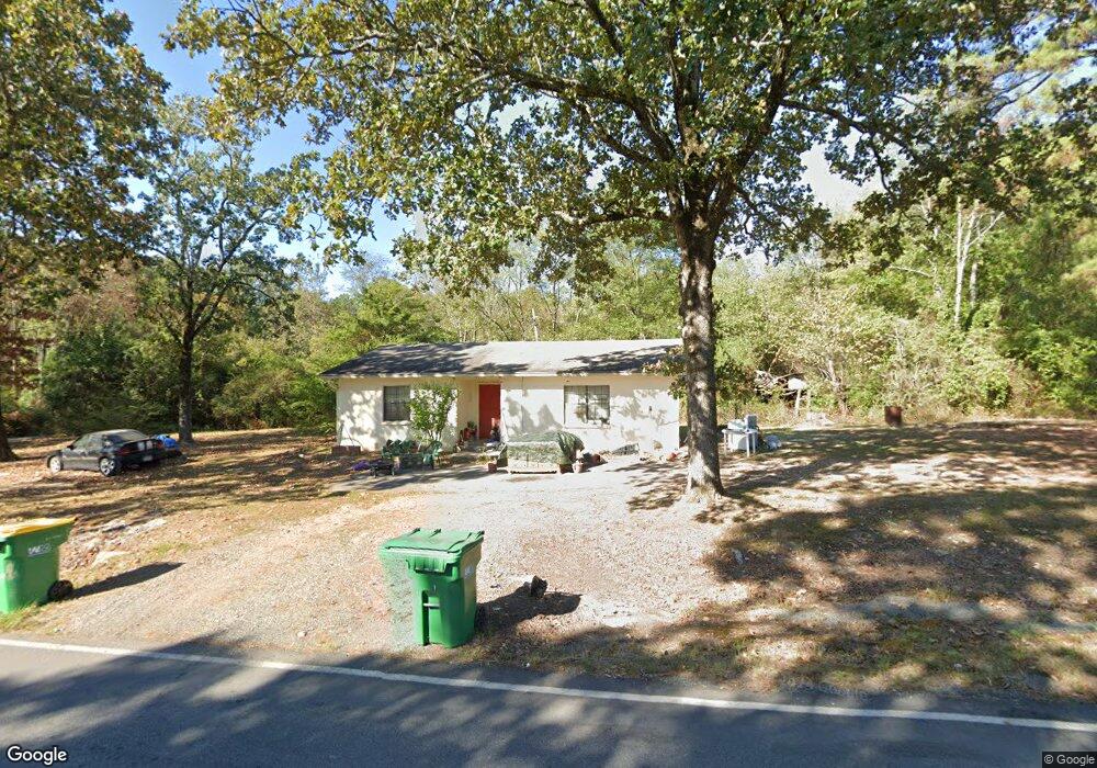
5214 Sullivan Rd Little Rock, AR 72210
Western Little Rock NeighborhoodEstimated Value: $75,000 - $197,000
--
Bed
1
Bath
1,100
Sq Ft
$126/Sq Ft
Est. Value
About This Home
This home is located at 5214 Sullivan Rd, Little Rock, AR 72210 and is currently estimated at $138,305, approximately $125 per square foot. 5214 Sullivan Rd is a home located in Pulaski County with nearby schools including Lawson Elementary School, Joe T. Robinson Middle School, and Joe T. Robinson High School.
Ownership History
Date
Name
Owned For
Owner Type
Purchase Details
Closed on
Oct 1, 2018
Sold by
Johnson Darrell and Johnson Barbara
Bought by
Bar Dar Llc
Current Estimated Value
Purchase Details
Closed on
Oct 6, 2017
Sold by
Johnson Roger A and Johnson Judy
Bought by
Johnson Darrell W and Johnson Barbara
Purchase Details
Closed on
Aug 18, 2015
Sold by
Johnson Darrell and Johnson Roger Allen
Bought by
Johnson Darrell
Purchase Details
Closed on
Oct 1, 2008
Sold by
Duncan Margie Irene
Bought by
Duncan Margie Irene and The Margie Irene Duncan Revocable Trust
Create a Home Valuation Report for This Property
The Home Valuation Report is an in-depth analysis detailing your home's value as well as a comparison with similar homes in the area
Home Values in the Area
Average Home Value in this Area
Purchase History
| Date | Buyer | Sale Price | Title Company |
|---|---|---|---|
| Bar Dar Llc | -- | None Available | |
| Johnson Darrell W | $75,000 | Pulaski County Title | |
| Johnson Darrell | -- | Attorney | |
| Duncan Margie Irene | -- | None Available |
Source: Public Records
Tax History Compared to Growth
Tax History
| Year | Tax Paid | Tax Assessment Tax Assessment Total Assessment is a certain percentage of the fair market value that is determined by local assessors to be the total taxable value of land and additions on the property. | Land | Improvement |
|---|---|---|---|---|
| 2025 | $1,069 | $22,000 | $1,440 | $20,560 |
| 2024 | $917 | $22,000 | $1,440 | $20,560 |
| 2023 | $917 | $22,000 | $1,440 | $20,560 |
| 2022 | $915 | $22,000 | $1,440 | $20,560 |
| 2021 | $815 | $15,050 | $2,880 | $12,170 |
| 2020 | $815 | $15,050 | $2,880 | $12,170 |
| 2019 | $626 | $15,050 | $2,880 | $12,170 |
| 2018 | $582 | $15,050 | $2,880 | $12,170 |
| 2017 | $538 | $15,050 | $2,880 | $12,170 |
| 2016 | $443 | $8,730 | $3,150 | $5,580 |
| 2015 | $443 | $8,730 | $3,150 | $5,580 |
| 2014 | $443 | $8,730 | $3,150 | $5,580 |
Source: Public Records
Map
Nearby Homes
- 4718 McHenry Creek Cir
- 17419 Elvin Rd
- 18510 Crystal Valley Rd
- 15108 Angus Ct
- 18712 Lochridge Dr
- 15109 Angus Ct
- 18821 Lochridge Dr
- 6600 Shaner Cir
- 16011 Burleigh Ct
- 16025 Burleigh Ct
- 7015 Lucea Rd
- 3601 Jack Mann Rd
- 3209 Jack Mann Rd
- 18100 - 003 Raines Rd
- 18100 Raines Rd
- 0 Douglas Ln
- 14524 Lawson Rd
- 5 Secluded Point
- 20201 Running Creek Dr
- 105 Secluded Cir
- 17201 Lawson Rd
- 17124 Lawson Rd
- 5225 Sullivan Rd
- 17204 Lawson Rd
- 17210 Lawson Rd
- 5405 Sullivan Rd
- 17300 Lawson Rd
- 17200 Lawson Rd
- 17024 Lawson Rd
- 0 Sullivan Rd Unit 17009519
- 0 Sullivan Rd Unit 16012912
- 0 Sullivan Rd Unit 19017373
- 17016 Lawson Rd
- 17316 Lawson Rd
- 17100 Lawson Rd
- 5415 Sullivan Rd
- 15600 Minton Rd
- 17020 Lawson Rd
- 17412 Lawson Rd
- 17511 Lawson Rd