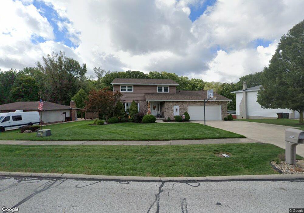
5217 Sassafras Dr Cleveland, OH 44129
Estimated Value: $324,000 - $357,000
4
Beds
3
Baths
2,197
Sq Ft
$152/Sq Ft
Est. Value
About This Home
This home is located at 5217 Sassafras Dr, Cleveland, OH 44129 and is currently estimated at $333,204, approximately $151 per square foot. 5217 Sassafras Dr is a home located in Cuyahoga County with nearby schools including Dentzler Elementary School, Normandy High School, and Hillside Middle School.
Ownership History
Date
Name
Owned For
Owner Type
Purchase Details
Closed on
Oct 2, 1996
Sold by
Hover Scott C
Bought by
Coon Thomas G and Coon Judith A
Current Estimated Value
Purchase Details
Closed on
Apr 23, 1986
Sold by
Santosuosso John E
Bought by
Hover Scott C
Purchase Details
Closed on
Apr 12, 1978
Bought by
Santosuosso John E
Purchase Details
Closed on
Jan 1, 1977
Bought by
Tiffany Homes Inc
Create a Home Valuation Report for This Property
The Home Valuation Report is an in-depth analysis detailing your home's value as well as a comparison with similar homes in the area
Home Values in the Area
Average Home Value in this Area
Purchase History
| Date | Buyer | Sale Price | Title Company |
|---|---|---|---|
| Coon Thomas G | $162,000 | -- | |
| Hover Scott C | $103,000 | -- | |
| Santosuosso John E | $78,500 | -- | |
| Tiffany Homes Inc | -- | -- |
Source: Public Records
Tax History Compared to Growth
Tax History
| Year | Tax Paid | Tax Assessment Tax Assessment Total Assessment is a certain percentage of the fair market value that is determined by local assessors to be the total taxable value of land and additions on the property. | Land | Improvement |
|---|---|---|---|---|
| 2024 | $5,769 | $95,620 | $18,830 | $76,790 |
| 2023 | $5,101 | $72,910 | $16,000 | $56,910 |
| 2022 | $5,057 | $72,910 | $16,000 | $56,910 |
| 2021 | $5,207 | $72,910 | $16,000 | $56,910 |
| 2020 | $4,935 | $61,250 | $13,440 | $47,810 |
| 2019 | $4,755 | $175,000 | $38,400 | $136,600 |
| 2018 | $4,575 | $61,250 | $13,440 | $47,810 |
| 2017 | $4,544 | $54,220 | $11,730 | $42,490 |
| 2016 | $4,515 | $54,220 | $11,730 | $42,490 |
| 2015 | $4,478 | $54,220 | $11,730 | $42,490 |
| 2014 | $4,478 | $55,900 | $12,080 | $43,820 |
Source: Public Records
Map
Nearby Homes
- 4803 Sassafras Dr
- 7531 Vista Dr
- 6417 Thoreau Dr
- 7272 Normandy Dr
- 5602 Ely Vista Dr
- 5810 Ely Vista Dr
- 4110 Pine Forest Dr
- 7580 S Pointe Ln
- 7596 S Pointe Ln
- 7351 S Pointe Ln
- Rosecliff Plan at South Pointe - Townhomes
- Caroline Plan at South Pointe - Townhomes
- 4477 Hialeah Dr
- 3610 Jeanne Dr
- 6001 Williston Dr
- 3807 Klusner Ave
- 7030 Lyle Ave
- 3711 Klusner Ave
- 3200 Dentzler Rd
- 6882 Day Dr
- 5303 Sassafras Dr
- 5207 Sassafras Dr
- 5309 Sassafras Dr
- 5201 Sassafras Dr
- 5216 Sassafras Dr
- 5300 Sassafras Dr
- 5306 Sassafras Dr
- 5210 Sassafras Dr
- 5401 Sassafras Dr
- 5204 Sassafras Dr
- 5312 Sassafras Dr
- 5117 Sassafras Dr
- 5405 Sassafras Dr
- 5114 Sassafras Dr
- 7293 Langerford Dr
- 5113 Sassafras Dr
- 5110 Sassafras Dr
- 7289 Langerford Dr
- 5409 Sassafras Dr
- 7285 Sassafras Dr