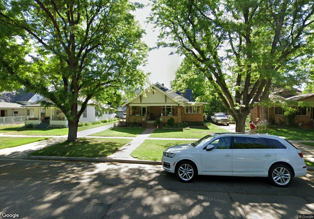
522 Pratt St Longmont, CO 80501
Sunset NeighborhoodEstimated Value: $838,000 - $1,030,012
4
Beds
3
Baths
2,320
Sq Ft
$409/Sq Ft
Est. Value
About This Home
This home is located at 522 Pratt St, Longmont, CO 80501 and is currently estimated at $949,503, approximately $409 per square foot. 522 Pratt St is a home located in Boulder County with nearby schools including Central Elementary School, Westview Middle School, and Longmont High School.
Ownership History
Date
Name
Owned For
Owner Type
Purchase Details
Closed on
Dec 15, 2005
Sold by
Brandt Matthew P
Bought by
Brandt Matthew P
Current Estimated Value
Purchase Details
Closed on
Apr 30, 2002
Sold by
Hillesland Lisa L and Stirling Glenn G
Bought by
Brandt Matthew P
Home Financials for this Owner
Home Financials are based on the most recent Mortgage that was taken out on this home.
Original Mortgage
$255,000
Outstanding Balance
$109,039
Interest Rate
7.11%
Estimated Equity
$840,464
Purchase Details
Closed on
Aug 16, 1999
Sold by
Topus David J
Bought by
Hillesland Lisa L
Home Financials for this Owner
Home Financials are based on the most recent Mortgage that was taken out on this home.
Original Mortgage
$225,000
Interest Rate
7.37%
Purchase Details
Closed on
Sep 13, 1995
Sold by
Meier Emily M
Bought by
Topus David J
Home Financials for this Owner
Home Financials are based on the most recent Mortgage that was taken out on this home.
Original Mortgage
$222,750
Interest Rate
7.45%
Purchase Details
Closed on
Jan 5, 1989
Bought by
Brandt Matthew P and Brandt Heather E
Purchase Details
Closed on
Oct 26, 1970
Bought by
Brandt Matthew P and Brandt Heather E
Create a Home Valuation Report for This Property
The Home Valuation Report is an in-depth analysis detailing your home's value as well as a comparison with similar homes in the area
Home Values in the Area
Average Home Value in this Area
Purchase History
| Date | Buyer | Sale Price | Title Company |
|---|---|---|---|
| Brandt Matthew P | -- | Security Title | |
| Brandt Matthew P | $350,000 | -- | |
| Hillesland Lisa L | $250,000 | First American Heritage Titl | |
| Topus David J | $247,500 | Commonwealth Land Title | |
| Brandt Matthew P | -- | -- | |
| Brandt Matthew P | $28,900 | -- |
Source: Public Records
Mortgage History
| Date | Status | Borrower | Loan Amount |
|---|---|---|---|
| Open | Brandt Matthew P | $255,000 | |
| Previous Owner | Hillesland Lisa L | $225,000 | |
| Previous Owner | Topus David J | $222,750 |
Source: Public Records
Tax History
| Year | Tax Paid | Tax Assessment Tax Assessment Total Assessment is a certain percentage of the fair market value that is determined by local assessors to be the total taxable value of land and additions on the property. | Land | Improvement |
|---|---|---|---|---|
| 2025 | $6,375 | $61,925 | $13,206 | $48,719 |
| 2024 | $8,400 | $66,645 | $11,095 | $55,550 |
| 2023 | $8,400 | $66,645 | $14,780 | $55,550 |
| 2022 | $7,599 | $54,141 | $10,877 | $43,264 |
| 2021 | $7,668 | $55,699 | $11,190 | $44,509 |
| 2020 | $6,829 | $47,226 | $9,009 | $38,217 |
| 2019 | $6,756 | $47,226 | $9,009 | $38,217 |
| 2018 | $6,404 | $43,826 | $10,368 | $33,458 |
| 2017 | $6,348 | $48,452 | $11,462 | $36,990 |
| 2016 | $6,042 | $39,761 | $13,214 | $26,547 |
Source: Public Records
Map
Nearby Homes
- 409 Terry St Unit B
- 831 4th Ave
- 331 Main St
- 400 Emery St Unit 202
- 832 Gay St
- 1129 2nd Ave
- 1301 Spruce Ave
- 402 Sherman St
- 1260 Longs Peak Ave
- 824 Kimbark St
- 348 Collyer St Unit 105
- 531 Atwood St
- 106 Lincoln St
- 306 Collyer St
- 422 Atwood St
- 344 Judson St
- 1401 3rd Ave
- 150 Francis St
- 140 Judson St
- 1006 Collyer St
Your Personal Tour Guide
Ask me questions while you tour the home.