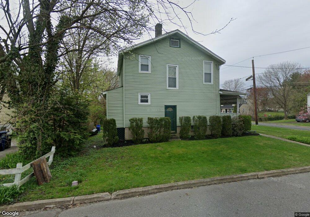
524 Bridge Ave Moorestown, NJ 08057
Estimated Value: $369,856 - $743,000
--
Bed
--
Bath
1,248
Sq Ft
$396/Sq Ft
Est. Value
About This Home
This home is located at 524 Bridge Ave, Moorestown, NJ 08057 and is currently estimated at $493,964, approximately $395 per square foot. 524 Bridge Ave is a home located in Burlington County with nearby schools including George C. Baker Elementary School, Moorestown Upper Elementary School, and William Allen Middle School.
Ownership History
Date
Name
Owned For
Owner Type
Purchase Details
Closed on
Jan 10, 1997
Sold by
Pollock Donald L
Bought by
Hemmings Marjorie O
Current Estimated Value
Home Financials for this Owner
Home Financials are based on the most recent Mortgage that was taken out on this home.
Original Mortgage
$20,400
Interest Rate
7.62%
Purchase Details
Closed on
Nov 11, 1996
Sold by
Daniels Gary L
Bought by
Pollock Donald L
Home Financials for this Owner
Home Financials are based on the most recent Mortgage that was taken out on this home.
Original Mortgage
$20,400
Interest Rate
7.62%
Create a Home Valuation Report for This Property
The Home Valuation Report is an in-depth analysis detailing your home's value as well as a comparison with similar homes in the area
Home Values in the Area
Average Home Value in this Area
Purchase History
| Date | Buyer | Sale Price | Title Company |
|---|---|---|---|
| Hemmings Marjorie O | $87,500 | Congress Title Corp | |
| Pollock Donald L | $22,700 | -- |
Source: Public Records
Mortgage History
| Date | Status | Borrower | Loan Amount |
|---|---|---|---|
| Previous Owner | Pollock Donald L | $20,400 |
Source: Public Records
Tax History Compared to Growth
Tax History
| Year | Tax Paid | Tax Assessment Tax Assessment Total Assessment is a certain percentage of the fair market value that is determined by local assessors to be the total taxable value of land and additions on the property. | Land | Improvement |
|---|---|---|---|---|
| 2025 | $5,980 | $210,800 | $121,700 | $89,100 |
| 2024 | $5,799 | $210,800 | $121,700 | $89,100 |
| 2023 | $5,799 | $210,800 | $121,700 | $89,100 |
| 2022 | $5,740 | $210,800 | $121,700 | $89,100 |
| 2021 | $5,664 | $210,800 | $121,700 | $89,100 |
| 2020 | $5,628 | $210,800 | $121,700 | $89,100 |
| 2019 | $5,529 | $210,800 | $121,700 | $89,100 |
| 2018 | $5,380 | $210,800 | $121,700 | $89,100 |
| 2017 | $5,426 | $210,800 | $121,700 | $89,100 |
| 2016 | $5,407 | $210,800 | $121,700 | $89,100 |
| 2015 | $5,342 | $210,800 | $121,700 | $89,100 |
| 2014 | $5,072 | $210,800 | $121,700 | $89,100 |
Source: Public Records
Map
Nearby Homes
- 543 Bethel Ave
- 493 N Church St
- 308 Farmdale Rd
- 316 Farmdale Rd
- 423 Park Blvd
- 313 Fairview Ave
- 316 W 3rd St
- 531 Covington Terrace
- 15 E 2nd St
- 4 W Close
- 129 S Church St
- 50 E 3rd St
- 66 E 3rd St
- 82 E 3rd St
- 80 E 3rd St
- 600 Stratford Dr
- 601 Stratford Dr
- 133 Plum St Unit 6
- 310 S Washington Ave
- 709 Manor Terrace
- 520 Bethel Ave
- 528 Bethel Ave
- 623 Bethel Ave
- 191 Bridge Ave
- 527 Bethel Ave
- 512 Bethel Ave
- 532 Bethel Ave
- 195 Bridge Ave
- 531 Bethel Ave
- 148 Coleman Terrace
- 535 Bethel Ave
- 525 N Church St
- 527 N Church St
- 144 Coleman Terrace
- 540 Bethel Ave
- 145 Coleman Terrace
- 521 N Church St
- 508 Bethel Ave
- 535 N Church St
- 539 Bethel Ave