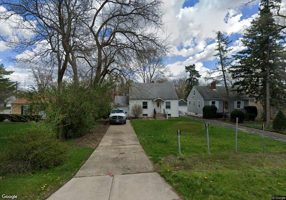
524 S Randall Rd Aurora, IL 60506
University Neighbors NeighborhoodEstimated Value: $219,000 - $270,000
3
Beds
1
Bath
1,044
Sq Ft
$237/Sq Ft
Est. Value
About This Home
This home is located at 524 S Randall Rd, Aurora, IL 60506 and is currently estimated at $247,865, approximately $237 per square foot. 524 S Randall Rd is a home located in Kane County with nearby schools including Freeman Elementary School, Washington Middle School, and West Aurora High School.
Ownership History
Date
Name
Owned For
Owner Type
Purchase Details
Closed on
Feb 28, 2023
Sold by
Skaggs Edwin
Bought by
H Edwin Skaggs Living Trust and Skaggs
Current Estimated Value
Purchase Details
Closed on
Sep 3, 2004
Sold by
Cook Marie G and Gomez Michael
Bought by
Skaggs Edwin
Home Financials for this Owner
Home Financials are based on the most recent Mortgage that was taken out on this home.
Original Mortgage
$128,700
Interest Rate
6.08%
Mortgage Type
Purchase Money Mortgage
Purchase Details
Closed on
Jan 25, 2002
Sold by
Weigerding Jeffrey A
Bought by
Gomez Michael and Cook Marie G
Home Financials for this Owner
Home Financials are based on the most recent Mortgage that was taken out on this home.
Original Mortgage
$123,500
Interest Rate
7.23%
Create a Home Valuation Report for This Property
The Home Valuation Report is an in-depth analysis detailing your home's value as well as a comparison with similar homes in the area
Home Values in the Area
Average Home Value in this Area
Purchase History
| Date | Buyer | Sale Price | Title Company |
|---|---|---|---|
| H Edwin Skaggs Living Trust | -- | None Listed On Document | |
| Skaggs Edwin | $135,500 | First American Title | |
| Gomez Michael | $130,000 | -- |
Source: Public Records
Mortgage History
| Date | Status | Borrower | Loan Amount |
|---|---|---|---|
| Previous Owner | Skaggs Edwin | $128,700 | |
| Previous Owner | Gomez Michael | $123,500 |
Source: Public Records
Tax History
| Year | Tax Paid | Tax Assessment Tax Assessment Total Assessment is a certain percentage of the fair market value that is determined by local assessors to be the total taxable value of land and additions on the property. | Land | Improvement |
|---|---|---|---|---|
| 2024 | $3,139 | $63,514 | $7,496 | $56,018 |
| 2023 | $2,913 | $56,750 | $6,698 | $50,052 |
| 2022 | $3,009 | $51,779 | $6,111 | $45,668 |
| 2021 | $2,828 | $48,206 | $5,689 | $42,517 |
| 2020 | $2,634 | $44,776 | $5,284 | $39,492 |
| 2019 | $2,497 | $41,486 | $4,896 | $36,590 |
| 2018 | $2,336 | $38,697 | $4,529 | $34,168 |
| 2017 | $2,122 | $35,392 | $4,173 | $31,219 |
| 2016 | $1,843 | $31,434 | $3,974 | $27,460 |
| 2015 | -- | $27,397 | $3,417 | $23,980 |
| 2014 | -- | $23,732 | $3,140 | $20,592 |
| 2013 | -- | $24,206 | $3,095 | $21,111 |
Source: Public Records
Map
Nearby Homes
- 527 S Calumet Ave
- 537 Hartford Ave
- 210 S Gladstone Ave
- 149 S Gladstone Ave
- 160 Ingleside Ave
- 175 S Harrison Ave
- 170 Alschuler Dr
- 231 W Downer Place
- 625 S Lake St
- Napa Plan at Prairie Meadows
- Siena Plan at Prairie Meadows
- Sonoma Plan at Prairie Meadows
- Rutherford Plan at Prairie Meadows
- 417 S Constitution Dr
- 433 Cottrell Ln
- 310-312 Prairie St
- 2021 Radcliffe Dr
- 425 Cottrell Ln
- 393 S Constitution Dr
- 381 S Constitution Dr
- 528 S Randall Rd
- 520 S Randall Rd
- 532 S Randall Rd
- 509 S Calumet Ave
- 507 S Calumet Ave
- 514 S Randall Rd
- 513 S Calumet Ave
- 517 S Calumet Ave
- 503 S Calumet Ave
- 548 S Randall Rd
- 521 S Calumet Ave
- 501 S Calumet Ave
- 525 S Calumet Ave
- 1342 Prairie St
- 1341 Ridgeway Ave
- 510 S Calumet Ave
- 512 S Calumet Ave
- 508 S Calumet Ave
- 1334 Prairie St
- 504 S Calumet Ave