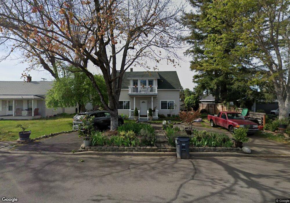
525 Ash St Central Point, OR 97502
Estimated Value: $345,000 - $434,000
3
Beds
2
Baths
2,166
Sq Ft
$183/Sq Ft
Est. Value
About This Home
This home is located at 525 Ash St, Central Point, OR 97502 and is currently estimated at $395,908, approximately $182 per square foot. 525 Ash St is a home located in Jackson County with nearby schools including Central Point Elementary School, Scenic Middle School, and Crater High School.
Ownership History
Date
Name
Owned For
Owner Type
Purchase Details
Closed on
Sep 7, 2018
Sold by
Richardson Dennis and Richardson Catherine
Bought by
Richardson Dennis Michael and Richardson Catherine Jean
Current Estimated Value
Purchase Details
Closed on
Jun 1, 2018
Sold by
Richardson Dennis M
Bought by
Richardson Family Trust
Purchase Details
Closed on
May 31, 2000
Sold by
Richardson Dennis Trste Fbo
Bought by
Winsor Rulon S and Rulon S Winsor Trust
Purchase Details
Closed on
Jul 29, 1999
Sold by
Fair L Wayne
Bought by
Richardson Dennis and The Richardson & Associates P
Create a Home Valuation Report for This Property
The Home Valuation Report is an in-depth analysis detailing your home's value as well as a comparison with similar homes in the area
Home Values in the Area
Average Home Value in this Area
Purchase History
| Date | Buyer | Sale Price | Title Company |
|---|---|---|---|
| Richardson Dennis Michael | -- | None Available | |
| Richardson Family Trust | -- | None Available | |
| Winsor Rulon S | $93,000 | Key Title Company | |
| Richardson Dennis | $81,000 | Key Title Company |
Source: Public Records
Tax History Compared to Growth
Tax History
| Year | Tax Paid | Tax Assessment Tax Assessment Total Assessment is a certain percentage of the fair market value that is determined by local assessors to be the total taxable value of land and additions on the property. | Land | Improvement |
|---|---|---|---|---|
| 2025 | $3,107 | $186,860 | $58,700 | $128,160 |
| 2024 | $3,107 | $181,420 | $56,990 | $124,430 |
| 2023 | $3,007 | $176,140 | $55,330 | $120,810 |
| 2022 | $2,937 | $176,140 | $55,330 | $120,810 |
| 2021 | $2,853 | $171,010 | $53,720 | $117,290 |
| 2020 | $2,770 | $166,030 | $52,150 | $113,880 |
| 2019 | $2,701 | $156,510 | $49,160 | $107,350 |
| 2018 | $2,619 | $151,960 | $47,730 | $104,230 |
| 2017 | $2,553 | $151,960 | $47,730 | $104,230 |
| 2016 | $2,479 | $143,250 | $44,990 | $98,260 |
| 2015 | $2,296 | $143,250 | $44,990 | $98,260 |
| 2014 | $2,208 | $135,030 | $42,410 | $92,620 |
Source: Public Records
Map
Nearby Homes
- 715 Ash St
- 350 Alder St
- 340 Freeman Rd
- 840 Ash St
- 531 Bush St
- 114 Cedar St
- 555 Freeman Rd Unit 128
- 555 Freeman Rd Unit 146
- 555 Freeman Rd Unit 204
- 555 Freeman Rd Unit 209
- 144 N 5th St
- 546 Laurel St
- 845 Manzanita St
- 301 Freeman Rd Unit 100
- 301 Freeman Rd Unit 23
- 301 Freeman Rd Unit 85
- 755 S 4th St
- 448 Cheney Loop
- 571 Briarwood Dr
- 431 N 5th St