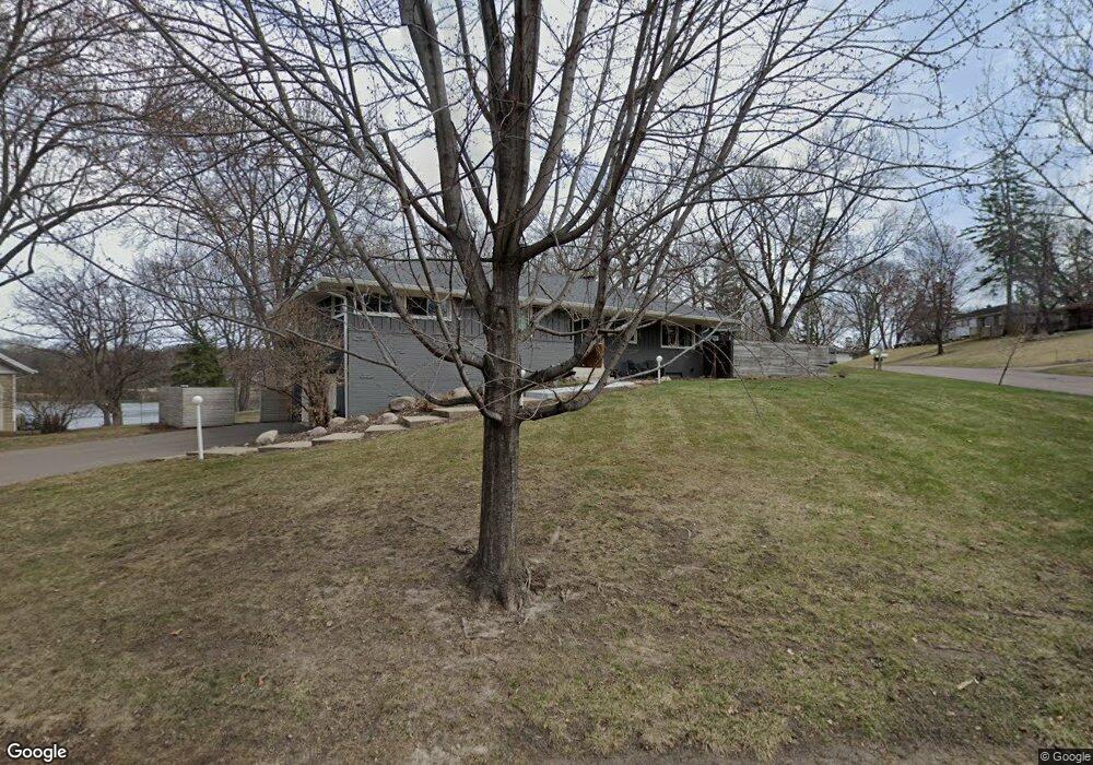
5251 Kimberly Rd Minnetonka, MN 55345
Spring Hill Park NeighborhoodEstimated Value: $483,364 - $601,000
3
Beds
2
Baths
1,620
Sq Ft
$335/Sq Ft
Est. Value
About This Home
This home is located at 5251 Kimberly Rd, Minnetonka, MN 55345 and is currently estimated at $542,591, approximately $334 per square foot. 5251 Kimberly Rd is a home located in Hennepin County with nearby schools including Scenic Heights Elementary School, Minnetonka East Middle School, and Minnetonka Senior High School.
Ownership History
Date
Name
Owned For
Owner Type
Purchase Details
Closed on
Mar 3, 2017
Sold by
Dille Stevne and Dille Karen
Bought by
Dille Jennifer L
Current Estimated Value
Purchase Details
Closed on
Apr 5, 2013
Sold by
Cornell Adam and Cornell Aubrey J
Bought by
Dille Steven and Dille Karen
Purchase Details
Closed on
Jun 27, 2008
Sold by
Rypka Timothy C and Harris Cara D
Bought by
Cornell Adam and Cornell Aubrey J
Purchase Details
Closed on
Aug 28, 2000
Sold by
Burglund Kenneth and Burglund Audrey
Bought by
Rypka Timothy and Rypka Cara
Create a Home Valuation Report for This Property
The Home Valuation Report is an in-depth analysis detailing your home's value as well as a comparison with similar homes in the area
Home Values in the Area
Average Home Value in this Area
Purchase History
| Date | Buyer | Sale Price | Title Company |
|---|---|---|---|
| Dille Jennifer L | -- | None Available | |
| Dille Steven | -- | None Available | |
| Cornell Adam | $280,000 | -- | |
| Rypka Timothy | $222,500 | -- |
Source: Public Records
Tax History
| Year | Tax Paid | Tax Assessment Tax Assessment Total Assessment is a certain percentage of the fair market value that is determined by local assessors to be the total taxable value of land and additions on the property. | Land | Improvement |
|---|---|---|---|---|
| 2024 | $5,615 | $433,600 | $202,400 | $231,200 |
| 2023 | $5,381 | $432,700 | $202,400 | $230,300 |
| 2022 | $4,791 | $399,900 | $202,400 | $197,500 |
| 2021 | $4,693 | $354,200 | $184,000 | $170,200 |
| 2020 | $4,843 | $348,200 | $184,000 | $164,200 |
| 2019 | $4,722 | $344,500 | $184,000 | $160,500 |
| 2018 | $4,439 | $329,800 | $184,000 | $145,800 |
| 2017 | $4,372 | $300,500 | $166,700 | $133,800 |
| 2016 | $4,351 | $297,600 | $149,500 | $148,100 |
| 2015 | $4,180 | $284,100 | $150,000 | $134,100 |
| 2014 | -- | $245,200 | $150,000 | $95,200 |
Source: Public Records
Map
Nearby Homes
- 15904 Dawn Dr
- 16515 Hilltop Terrace
- 15840 Woodgate Rd N
- 16826 Excelsior Blvd
- 4902 Woodhurst Ln
- 15501 Excelsior Blvd
- 4757 Spring Cir
- 4801 Spring Cir
- 16633 Temple Dr N
- 5733 Scenic Heights Dr
- 17155 Sandy Ln
- 4944 W West End Ln
- 4939 Bayswater Rd
- 5800 Scenic Heights Dr
- 4811 Highland Rd
- 5912 Stoneybrook Dr
- 15395 Highland Bluff
- 14819 Cherry Ln
- 5942 Fairwood Ln
- 5311 Tracy Lynn Terrace
- 5243 Kimberly Rd
- 16040 Dawn Dr
- 5302 Kimberly Rd
- 16049 Dawn Dr
- 5248 Kimberly Rd
- 16032 Dawn Dr
- 16041 Dawn Dr
- 5326 Kimberly Rd
- 5240 Kimberly Rd
- 16033 Dawn Dr
- 5334 Kimberly Rd
- 16020 Dawn Dr
- 5227 Kimberly Rd
- 5343 Kimberly Rd
- 5301 Holiday Rd
- 5247 Holiday Rd
- 5228 Kimberly Rd
- 5340 Miracle Ln
- 5325 Holiday Rd
- 5342 Kimberly Rd
Your Personal Tour Guide
Ask me questions while you tour the home.