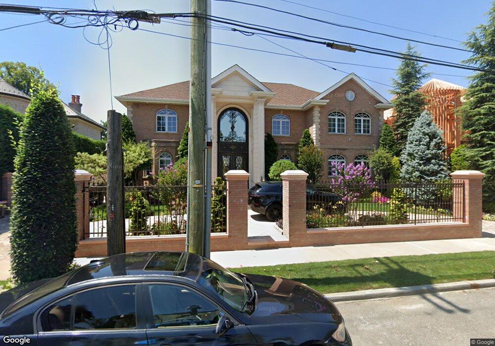
526 Parsons Blvd Whitestone, NY 11357
Whitestone NeighborhoodEstimated Value: $2,659,674 - $3,566,000
--
Bed
--
Bath
4,500
Sq Ft
$688/Sq Ft
Est. Value
About This Home
This home is located at 526 Parsons Blvd, Whitestone, NY 11357 and is currently estimated at $3,094,225, approximately $687 per square foot. 526 Parsons Blvd is a home located in Queens County with nearby schools including J.H.S. 194 William Carr, Flushing High School, and Holy Cross School Greek Orthodox Day School.
Ownership History
Date
Name
Owned For
Owner Type
Purchase Details
Closed on
Jun 12, 2001
Sold by
Reiter Ann
Bought by
Taranto Rosa and Taranto Joseph
Current Estimated Value
Home Financials for this Owner
Home Financials are based on the most recent Mortgage that was taken out on this home.
Original Mortgage
$200,000
Outstanding Balance
$75,619
Interest Rate
7.2%
Estimated Equity
$3,018,606
Create a Home Valuation Report for This Property
The Home Valuation Report is an in-depth analysis detailing your home's value as well as a comparison with similar homes in the area
Home Values in the Area
Average Home Value in this Area
Purchase History
| Date | Buyer | Sale Price | Title Company |
|---|---|---|---|
| Taranto Rosa | -- | -- |
Source: Public Records
Mortgage History
| Date | Status | Borrower | Loan Amount |
|---|---|---|---|
| Open | Taranto Rosa | $200,000 | |
| Open | Taranto Rosa | $399,000 |
Source: Public Records
Tax History Compared to Growth
Tax History
| Year | Tax Paid | Tax Assessment Tax Assessment Total Assessment is a certain percentage of the fair market value that is determined by local assessors to be the total taxable value of land and additions on the property. | Land | Improvement |
|---|---|---|---|---|
| 2025 | $22,022 | $116,220 | $12,148 | $104,072 |
| 2024 | $22,022 | $109,642 | $13,730 | $95,912 |
| 2023 | $22,022 | $109,642 | $11,861 | $97,781 |
| 2022 | $21,724 | $175,680 | $20,640 | $155,040 |
| 2021 | $21,605 | $145,620 | $20,640 | $124,980 |
| 2020 | $20,500 | $135,660 | $20,640 | $115,020 |
| 2019 | $19,113 | $149,460 | $20,640 | $128,820 |
| 2018 | $18,625 | $91,368 | $10,790 | $80,578 |
| 2017 | $18,486 | $90,683 | $14,687 | $75,996 |
| 2016 | $17,102 | $90,683 | $14,687 | $75,996 |
| 2015 | $11,584 | $80,708 | $20,243 | $60,465 |
| 2014 | $11,584 | $76,140 | $22,920 | $53,220 |
Source: Public Records
Map
Nearby Homes
- 6 Summit Place
- 144-58 Boulevard
- 2-07 Parsons Blvd
- 95 Malba Dr Unit 1
- 104 Malba Dr
- 145-45 4th Ave
- 145-67 5th Ave
- 915 Malba Dr
- 707 147th St
- 147-07 8th Ave
- 118 Malba Dr
- 145-52 10th Ave
- 4 Point Crescent
- 14703 10th Ave
- 141-37 11th Ave
- 147-47 8th Ave
- 141-16 11th Ave
- 2-44 149th St
- 14910 7th Ave
- 149-27 6th Ave
- 518 Parsons Blvd
- 175 25nden Blvd 1
- 603 Parsons Blvd
- 512 Parsons Blvd
- 512 Parsons Blvd Unit House
- 512 Parsons Blvd
- 603 Parsons Blvd
- 605 Parsons Blvd
- 611 Parsons Blvd
- 86 Parsons Blvd
- 2 Summit Place
- 88 Parsons Blvd
- 90 Parsons Blvd
- 6-11 Parsons Blvd
- 5 Avenue
- 4 Summit Place
- 4 Summit Place
- 2 Summit Place
- 144-52 Boulevard
- 2 Summit Place